System and method for mobile station position determination along border areas

a technology for mobile stations and border areas, applied in direction finders using radio waves, instruments, wireless communication, etc., can solve the problems of low accuracy of mobile station position determination, existing systems may potentially measure time delays from locations, and inability to accurately determine the position of mobile stations in such scenarios. , to achieve the effect of very accurate determination of mobile station position

Inactive Publication Date: 2001-02-20
ERICSSON INC
View PDF1 Cites 24 Cited by
  • Summary
  • Abstract
  • Description
  • Claims
  • Application Information

AI Technical Summary

Benefits of technology

Upon completion of the TOA measurements, each LMU returns the measurement information to the VMSC. The timing measurements taken by the LMU(s) associated with the neighboring MSC are transmitted as a DTAP message to the neighboring MSC, after which the neighboring MSC encapsulates the DTAP message and forwards the encapsulated message to the VMSC. The VMSC unpacks the encapsulated DTAP message and sends the received DTAP messages to the MLC. Based upon the timing measurements, the MLC calculates the position of the mobile station. By employing one or more LMUs of a neighboring MSC in the TOA analysis so as to suitably surround the mobile station to be located, the position of the mobile station is very accurately determined.

Problems solved by technology

Although the above-described system illustrates considerable progress in the cellular position determination field, there are still a number of deficiencies to be improved upon.
There are circumstances in existing systems having TOA-based mobile station positioning capabilities in which the determination of a mobile station position may not be highly accurate.
Existing systems may potentially measure time delays from locations which fail to surround the mobile station to be located, especially when the mobile station is located near the border between two areas served by separate mobile switching centers (MSCs) or other entities within the network.
Consequently, location determinations in such a scenario will not be highly accurate.

Method used


Image

  • System and method for mobile station position determination along border areas
  • System and method for mobile station position determination along border areas
  • System and method for mobile station position determination along border areas

Examples


Embodiment Construction

The present invention will now be described more fully hereinafter with reference to the accompanying drawings in which a preferred embodiment of the invention is shown. This invention may, however, be embodied in many different forms and should not be construed as being limited to the embodiment set forth herein. Rather, the embodiment is provided so that this disclosure will be thorough and complete, and will fully convey the scope of the invention to those skilled in the art.

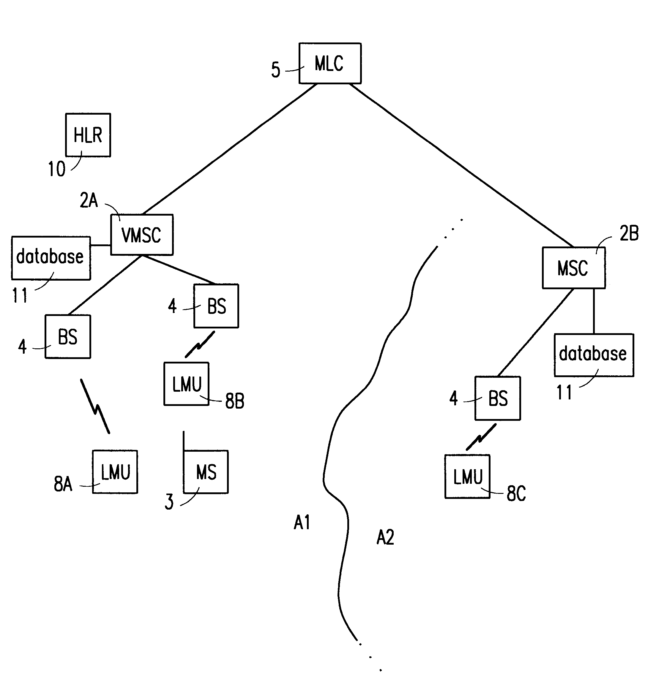
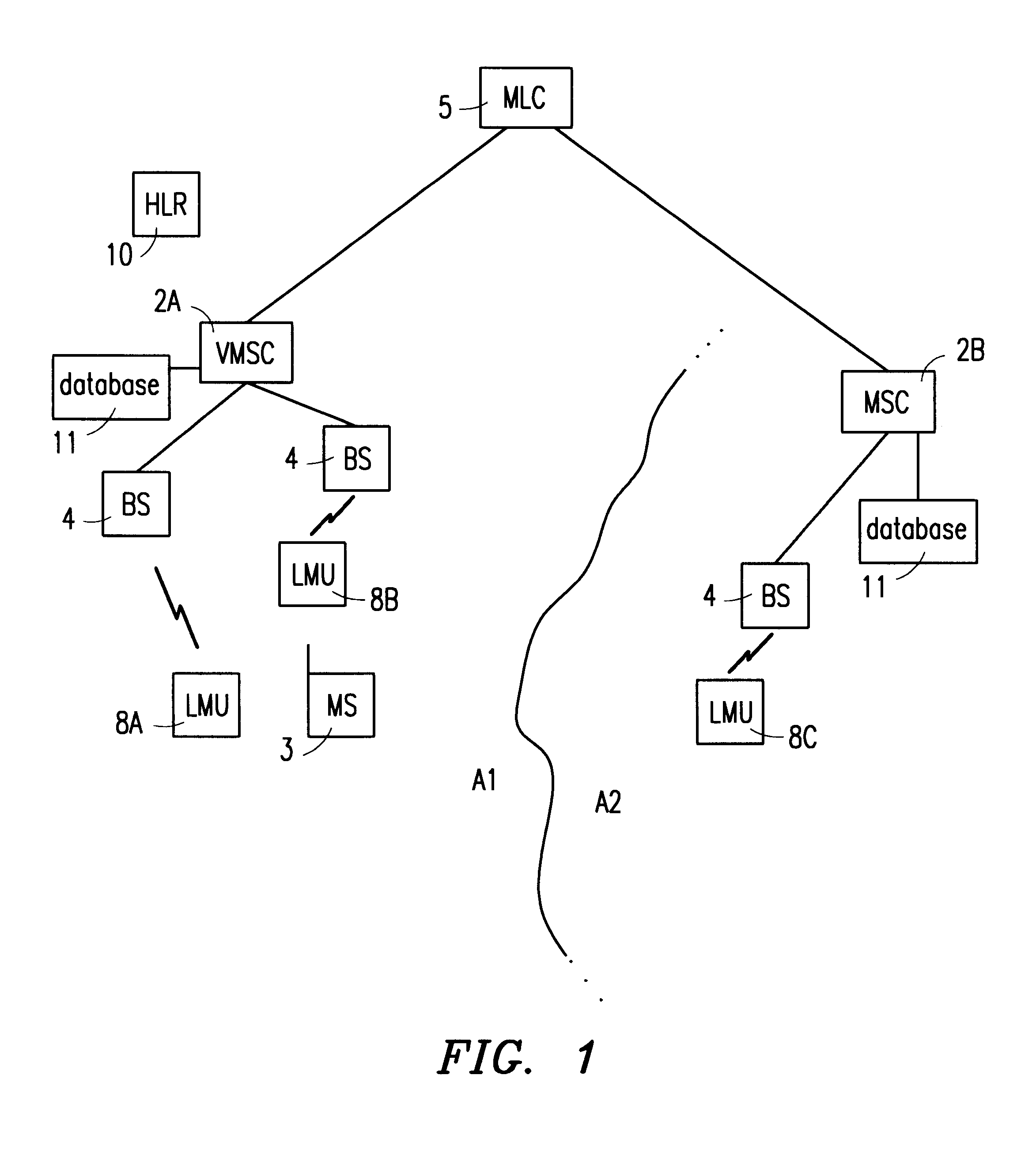
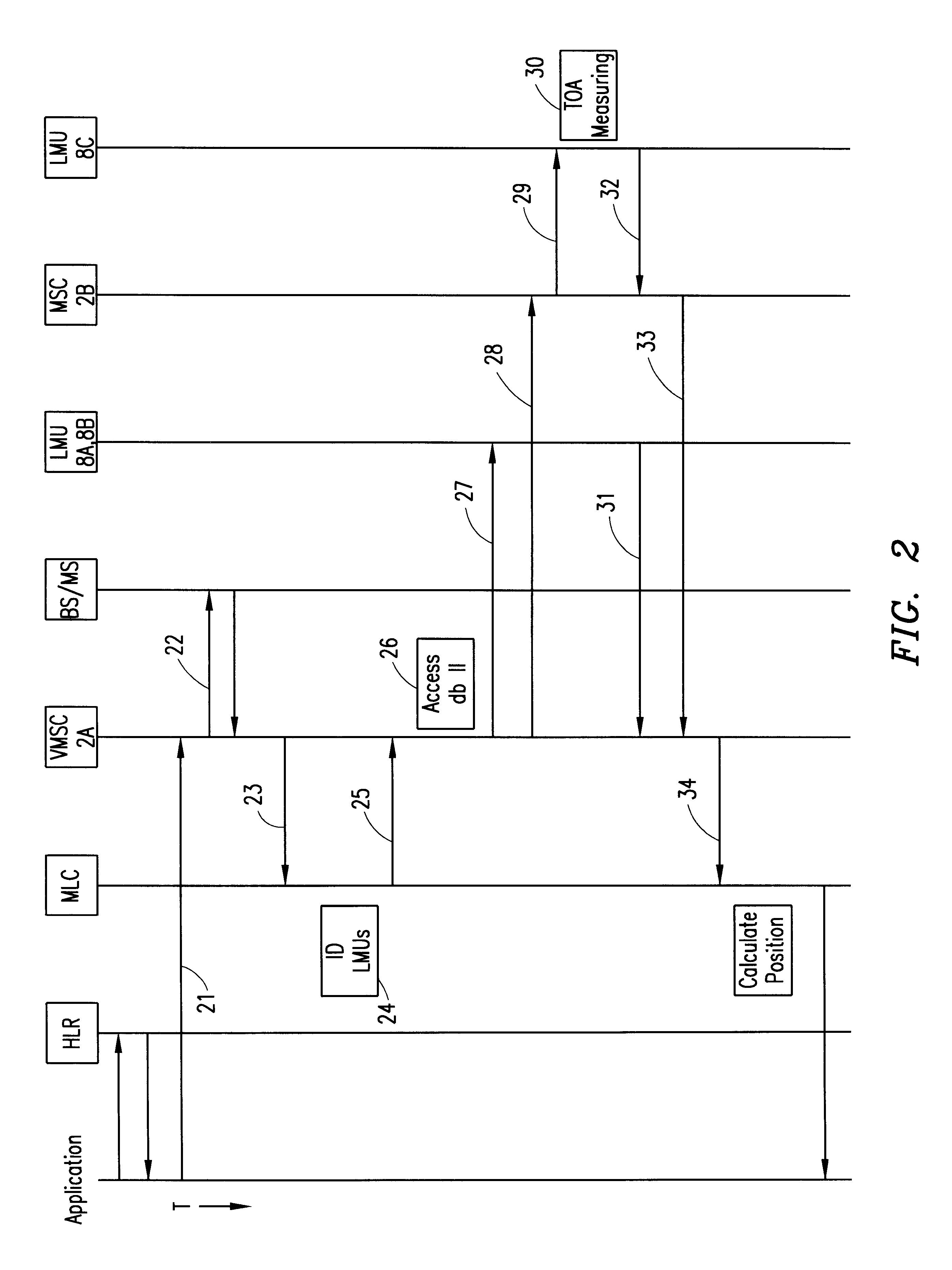
Referring to FIG. 1, there is shown a mobile cellular telecommunications system 1 according to the present invention. Telecommunications network 1 preferably includes a plurality of mobile switching centers (MSCs) 2 which provide call set-up, routing, control and termination operations to one or more mobile stations 3. Each MSC 2 is preferably associated with one or more base stations 4 so as to serve a specific geographical area within the telecommunications network. The communicative relationship between a ...


PUM


Abstract

An improved system and method for determining a position of a mobile station in a mobile telecommunications system is disclosed. The system includes identifying a number of location measuring units (LMUs) for measuring the time of arrival of signals generated by the mobile station. In the event one or more of the LMUs is associated with a mobile switching center (MSC) other than the MSC serving the mobile station, then information pertaining to the identified LMUs and the other MSC is sent to the serving MSC. The serving MSC sends a position request message to those identified LMUs associated therewith, encapsulates the position request message and sends the encapsulated message to the other MSC. The other MSC thereafter unpacks the position request message and forwards the unpacked position request message to the identified LMU associated with the other MSC. Following the measuring of timing information, the LMU associated with the other MSC sends its timing measurement results to the other MSC, which thereupon encapsulates the results and forwards the encapsulated results to the serving MSC.

Description

1. Technical Field of the InventionThe present invention relates, in general, to determining the position of a mobile station within a mobile cellular telecommunications network, and specifically to a system and method for more accurately determining mobile station position along border regions within the mobile cellular telecommunications network.2. Background and Objects of the InventionMobile radio position determination is an emerging field that has gained a great deal of interest lately, and it is now desirable to include a position determination capability in future cellular mobile radio systems. The Time Difference of Arrival (TDOA) position determination method, which is known from military applications, has been used successfully for determining the position of mobile radio terminals. A typical TDOA position determination system can be either terminal based, whereby Time Of Arrival (TOA) measurements are made on the "downlink" in the mobile station (MS), or network based, w...

Claims


Application Information

Patent Timeline
Patent Type & Authority Patents(United States)
IPC IPC(8): G01S5/00G01S5/02H04Q7/38G01S5/06G01S19/09G01S19/46H04W64/00
CPCG01S5/0081G01S5/02H04W64/00G01S5/06G01S2205/008
Inventor HAVINIS, THEODOREPAPADIMITRIOU, DIMITRIS
Owner ERICSSON INC
Why Eureka
Try Eureka