Bird's-eye view forming method, map display apparatus and navigation system

Inactive Publication Date: 2002-02-12
CLARION CO LTD
View PDF14 Cites 44 Cited by
  • Summary
  • Abstract
  • Description
  • Claims
  • Application Information

AI Technical Summary

Benefits of technology

Therefore, the drawing judgment means of the present invention preferably eliminates, from targets to be drawn (displayed), those character strings which are obtained through the perspective projection of the map and which are located at positions higher than a predetermined display height from the bottom side of the display frame. Or the drawing judgement means may eliminate those character strings which are defined at position where is further than a fixed distance from the view point. As described above, the character strings are not disp

Problems solved by technology

Therefore, in order to simultaneously display two spots which are far away from each other, a reduction-scal

Method used


Image

  • Bird's-eye view forming method, map display apparatus and navigation system
  • Bird's-eye view forming method, map display apparatus and navigation system
  • Bird's-eye view forming method, map display apparatus and navigation system

Examples


Embodiment Construction

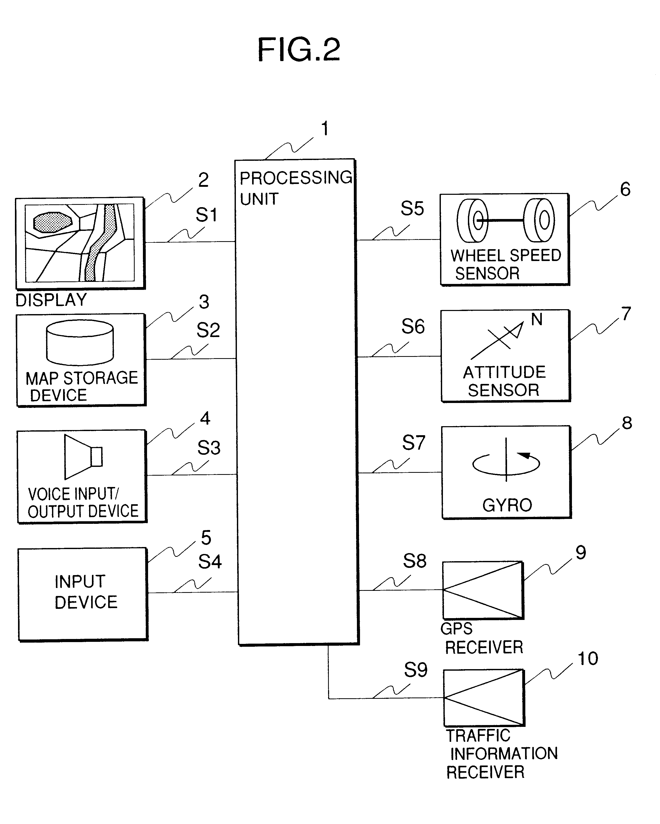
A preferred embodiment according to the present invention will be described with the accompanying drawings. In the following embodiment, the navigation system is mounted on a vehicle such as a car or the like, but, the same effect can be obtained when the navigation system is mounted on other moving bodies such as a ship, a train, etc.

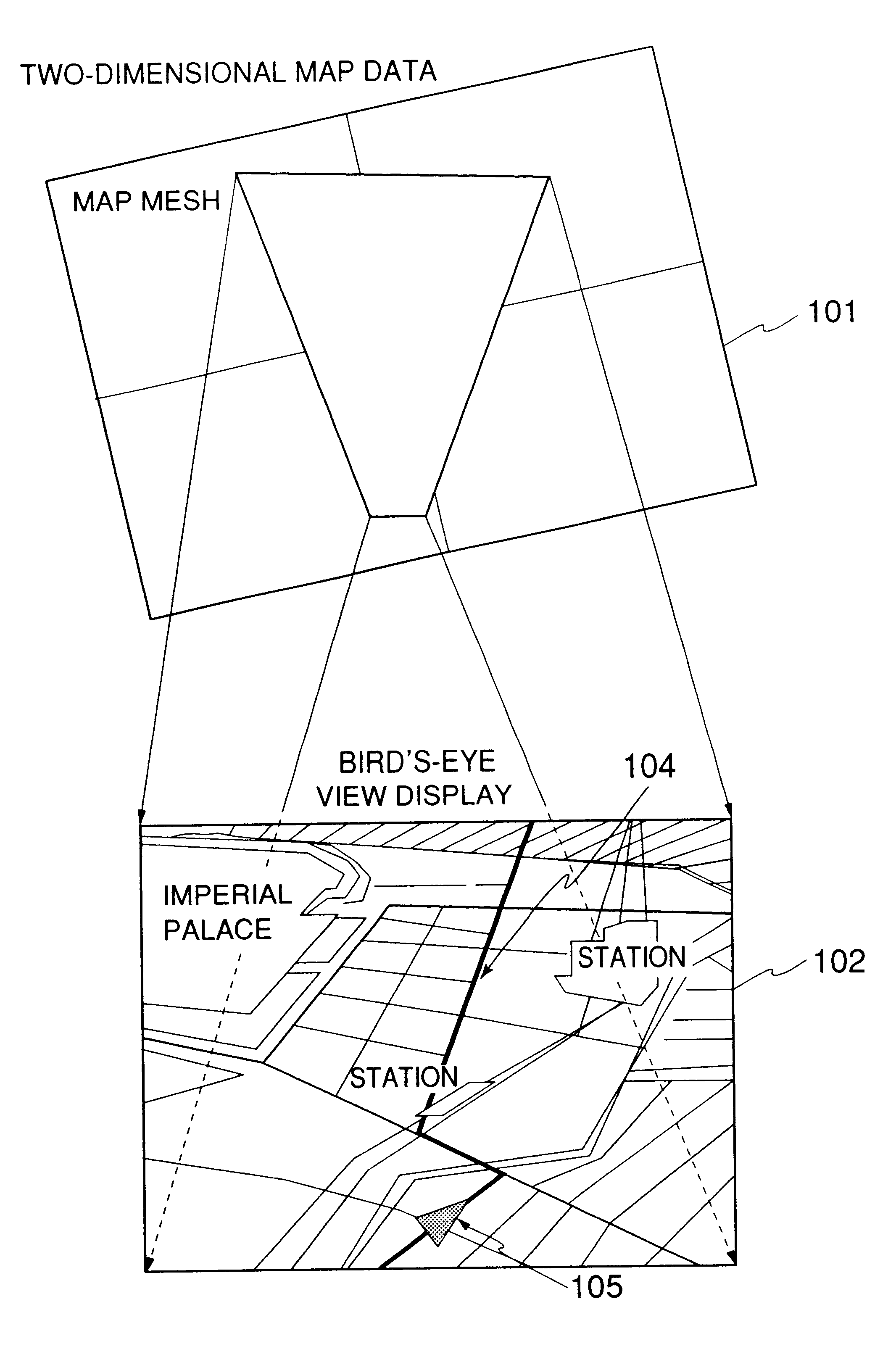
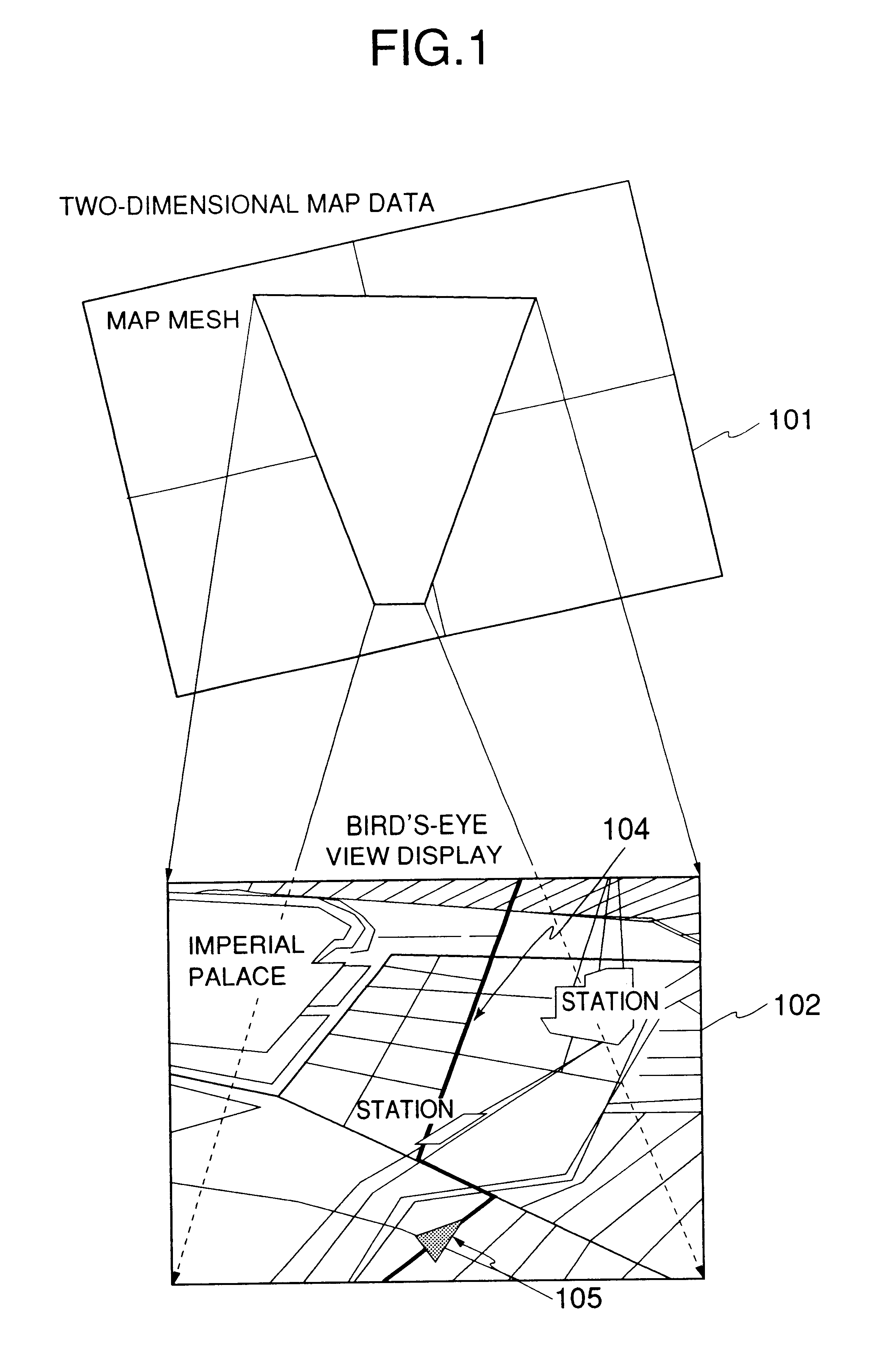
FIG. 1 shows a bird's-eye view which is displayed by a bird's-eye view map display apparatus installed in a navigation system of an embodiment according to the present invention. The bird's-eye view map display apparatus of this embodiment forms a bird's-eye view showing a landscape obtained through a bird's eye as a projection drawing of two-dimensional map data (represented by reference numeral 101 in FIG. 1), and displays it on a display screen of a display. Here, the bird's-eye view is defined as a view of a landscape which is obtained as if it is viewed through the eyes of a bird flying at a specific position which is high above the ground.

In FIG....


PUM


Abstract

In a navigation system using a bird's-eye view display mode, map data on a plan view map are subjected to a perspective projection conversion to obtain drawing data on a bird's-eye view map. In this case, an input of the position of a view point is accepted, and a projection plane for a bird's-eye view is determined on the basis of the coordinates of a current position and a destination and the position of the view point so that the display positions of the two points which have been subjected to perspective-projection conversion are coincident with predetermined positions. Alternatively, an input of a scale is accepted, and the position of the view point and the projection plane are determined on the basis of the coordinates of the two points and the scale so that the display positions of the two points after the perspective projection conversion are coincident with predetermined positions and the drawing scale is coincident with the input scale. Or, as a further alternative, an input of the projection angle is accepted, and the projection plane is determined on the basis of the projection angle and the position of the view point.

Description

BACKGROUND OF THE INVENTION1. Field of the InventionThe present invention relates to a navigation system for detecting the position of a moving body to inform a user of the current position of the moving body, and a map display apparatus using the navigation system.2. Description of Related ArtVarious types of navigation systems have been recently known, and these navigation systems are used while mounted on moving bodies such as vehicles, ships, etc. When such a navigation system is mounted on a moving body, it performs arithmetic and logic processing on information provided from various sensors to detect the current position of the moving body and display the current position on a screen of the navigation system.This type of navigation system includes a position detector for detecting the absolute position of the moving body, a storage device for storing map data which include two-dimensional vector data obtained by projecting roads and points on the ground, such as structures, et...

Claims


Application Information

Patent Timeline
IPC IPC(8): G01C21/36G01C21/34G09B29/10G01C21/00G06F17/30G08G1/0969
CPCG01C21/3635G09B29/106G01C21/3673G01C21/367
Inventor ENDO, YOSHINORIFUJIWARA, TOSHIOSATAKE, HIROYUKISHOJIMA, HIROSHIKISHI, NORIMASAWATANABE, MASAKIHIRANO, MOTOKI
Owner CLARION CO LTD
Why Eureka
Try Eureka