Method and apparatus for determining time in a satellite positioning system

Inactive Publication Date: 2002-08-13
SNAPTRACK
View PDF41 Cites 87 Cited by
  • Summary
  • Abstract
  • Description
  • Claims
  • Application Information

AI Technical Summary

Problems solved by technology

However, SPS receivers typically do not have such an accurate clock.
However, since signals from satellites travel at or approximately the speed of light, even a 1 millisecond ambiguity in time may result in an error of up to 300 kilometers in the pseudorange measurement.
Unfortunately, in many situations, determining the system time

Method used


Image

  • Method and apparatus for determining time in a satellite positioning system
  • Method and apparatus for determining time in a satellite positioning system
  • Method and apparatus for determining time in a satellite positioning system

Examples


Embodiment Construction

UTILIZING SATELLITE VELOCITY FOR TIME DETERMINATION

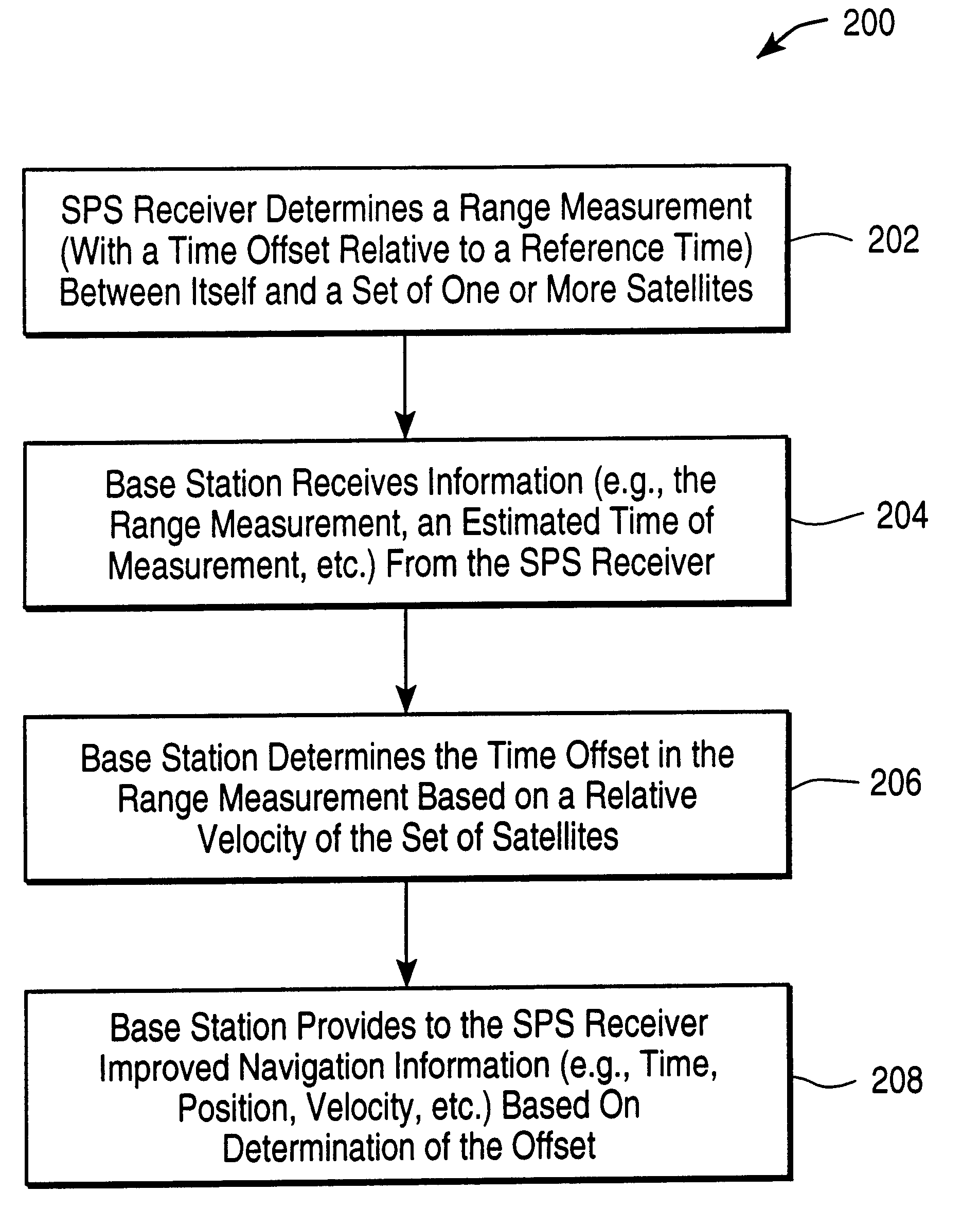
FIG. 2 is a flow diagram illustrating a method for utilizing relative satellite velocity for time determination in a satellite positioning system, according to one embodiment of the invention, as may be utilized with a mobile SPS receiver which is combined with a mobile communication receiver and transmitter, such as that shown in FIG. 1A. In the method 200 shown in FIG. 2, an entity, such as a mobile SPS receiver 100 shown in FIG. 1A, estimates its position to a set of one or more satellites in step 202. In one embodiment, the SPS receiver may determine a set of pseudoranges to the set of satellite based on signals transmitted from the satellites. As such, any range or position estimate by the SPS receiver will typically be offset relative to an actual position or range, due to an offset between the time of measurement as provided by the clock of the SPS receiver, and a reference time.

In step 204, a basestation, such as the basesta...


PUM


Abstract

A method and apparatus for determining a reference time associated with a satellite positioning system. In turn, the reference time, in one embodiment, may be used to determine other navigational information. Such navigational information may include, for example, the location/position of a satellite positioning system (SPS) receiver. In one embodiment, a relative velocity between an SPS receiver and a set of one or more satellites is used to determine an offset between time as indicated by the SPS receiver and the reference time. According to another embodiment of the invention, an error statistic is used to determine the reference time. According to yet another embodiment of the invention, two records, each representing at least a portion of a satellite message, are compared to determine time. In one implementation, the SPS receiver is mobile and operates in conjunction with a basestation to determine time and/or other navigational information according to one or a combination of the methods described.

Description

1. Field of the InventionThis invention relates to satellite positioning systems (SPS), and in particular, to determining time associated with SPS signal transmission and / or reception.2. Background InformationSPS receivers such as GPS (Global Positioning System) receivers normally determine their position by computing relative times of arrival of signals transmitted simultaneously from a multiplicity of satellites such as GPS (or NAVSTAR) satellites. In typical satellite positioning systems, such as GPS, the multiplicity of satellites are synchronized according to a highly accurate system clock, which may provide atomic clock accuracy. Generally, each satellite transmits navigational data (e.g., the location of the satellite) that also includes a time stamp to indicate when the data was transmitted, according to the time as indicated by the system clock (referred to hereafter as system time), which, in the case of GPS, is referred to as (GPS) system time.However, SPS receivers typic...

Claims


Application Information

Patent Timeline
IPC IPC(8): G01S1/02G01S1/00G01S5/00G01S5/14G04G7/02G04G7/00G01SG01S19/09G01S19/23G01S19/25G01S19/37G01S19/42
CPCG01S5/0009G01S5/0036G01S5/0063G01S19/09G01S19/23G01S19/235G01S19/24G01S19/246G01S19/25G01S19/256G01S19/37G01S19/39G01S19/42G04G7/02G04R20/02G04R20/04G04R20/06G01S5/0045G01S19/11G01S19/396G01S19/13
Inventor SHEYNBLAT, LEONIDKRASNER, NORMAN F.
Owner SNAPTRACK
Why Eureka
Try Eureka