
Method and system for route guiding

a route and route technology, applied in the field of route guiding, can solve the problems of high possibility of traffic accident occurrence, increased accident rate, and driver's eyes directed to the navigation system

Inactive Publication Date: 2002-11-12
ALPINE ELECTRONICS INC
View PDF4 Cites 26 Cited by
  • Summary
  • Abstract
  • Description
  • Claims
  • Application Information

AI Technical Summary

Problems solved by technology

The driver, however, must make efforts to drive the vehicle safely while checking the front and surrounding conditions because it is dangerous for the driver to direct his or her eyes to the navigation system frequently.
Particularly, in the vicinity of an intersection the driver should refrain from directing his or her eyes to the navigation system because the possibility of traffic accident occurrence is high.
As navigation systems become more popular, there is concern that there may be a greater number of accidents because the driver of a vehicle may look at the display portion of the navigation system too frequently or too long.
However, at least for a fairly long period after that name change, many people will have no idea whether the institution is a restaurant or an amusement institution or a public institution.
Because traffic accidents are apt to occur in the intersection and the driver's attention is distracted while driving the vehicle near the intersection, the guide by the navigation system rather becomes dangerous.
In making a software for a navigation system and when preparing guide data for intersections or the like, an attempt is made to select appropriate institutions as markers as referred to above, but such institutions as known to most people are extremely limited.
Particularly, there are various persons, including men and women of all ages, who utilize the navigation system and the object of interest differs depending on people, so the selection of institution names for guide is extremely difficult and appropriate institutions are not always selected.
In the above voice guide for intersections, when an institution name as a marker is guided, if the institution no longer exists or has changed to another institution, the user of the navigation system using old data is required to search for the guided institution in the vicinity of the intersection, which is very dangerous.
Particularly, in the case of chain restaurants and convenience stores, they tend to undergo drastic changes unlike roads and the like, so there is a fear that such conditions may occur frequently in a navigation system that guides institution names.

Method used


Image

  • Method and system for route guiding
  • Method and system for route guiding
  • Method and system for route guiding

Examples


Embodiment Construction

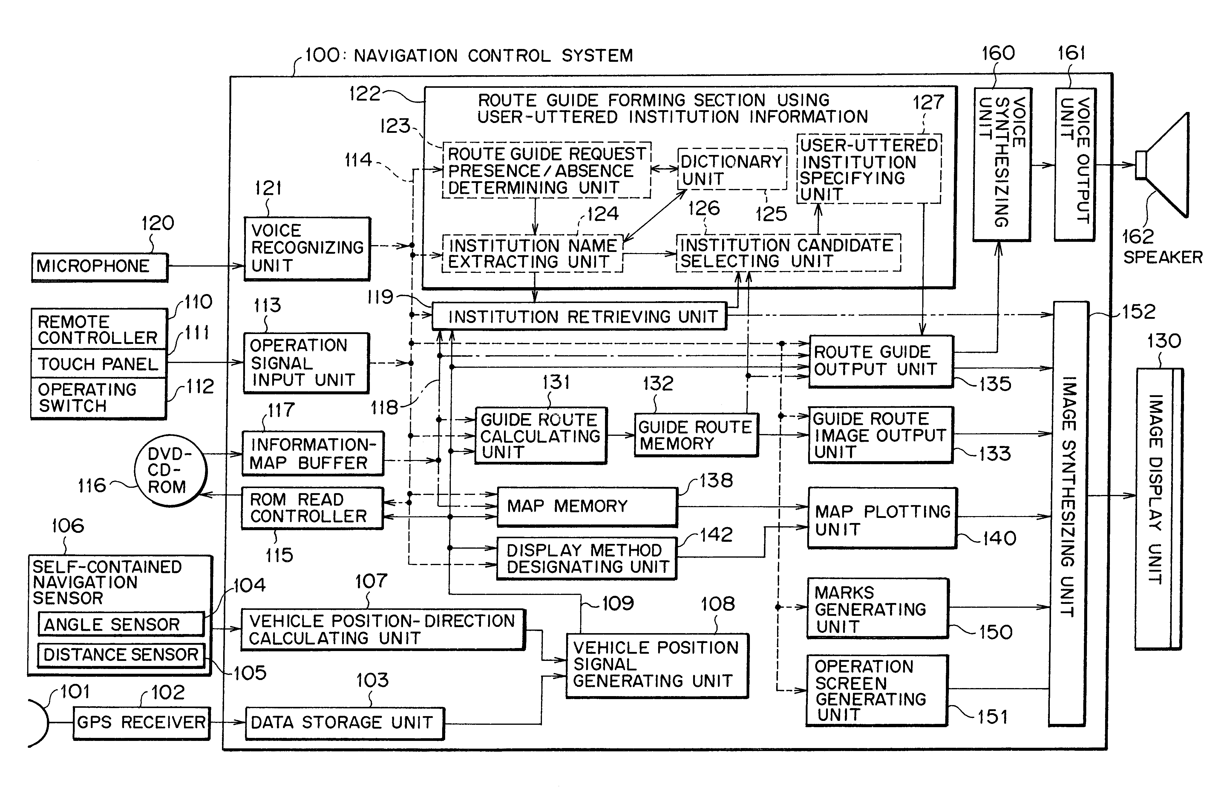
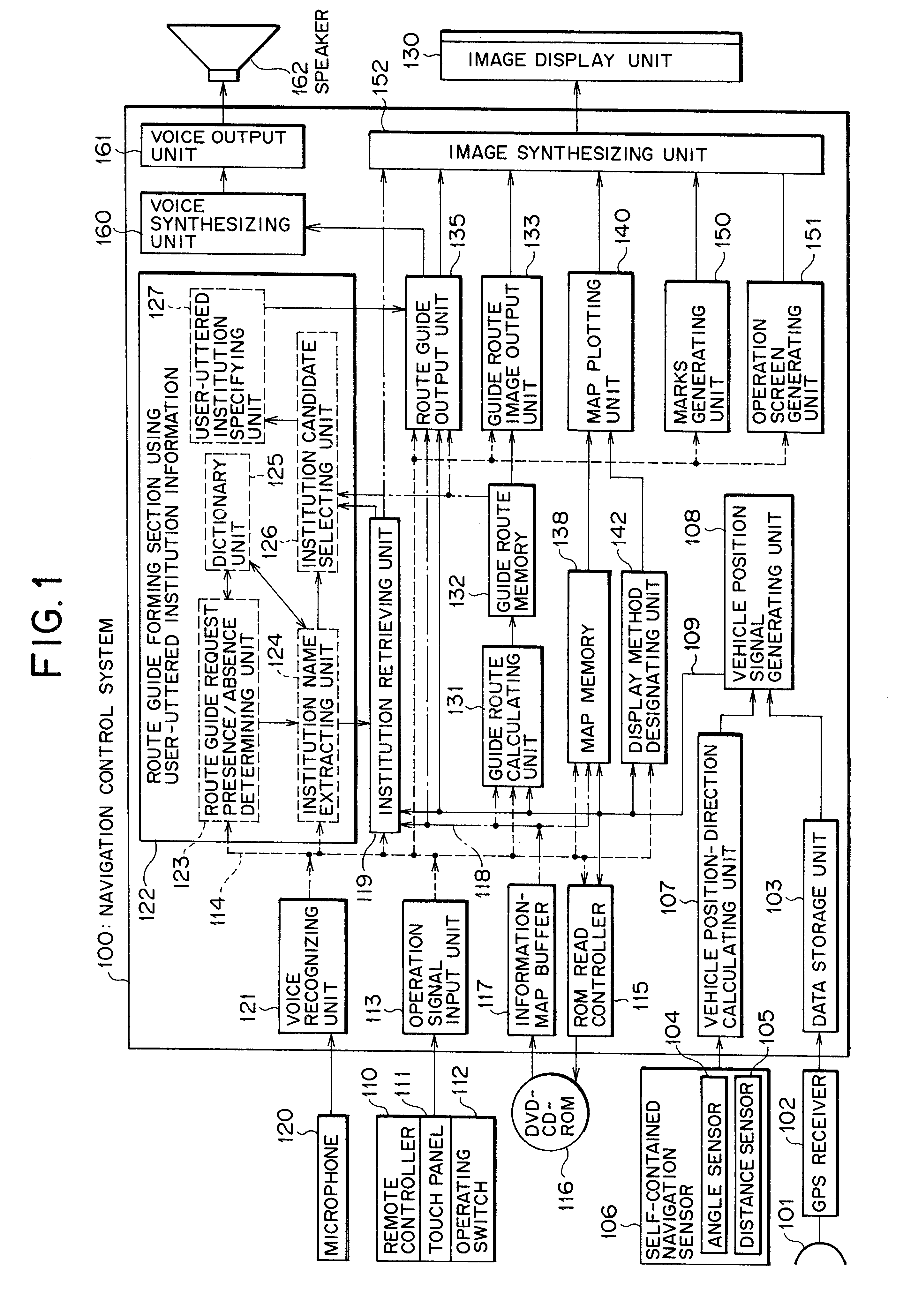
An embodiment of the present invention will now be described with reference to the accompanying drawings. FIG. 1 is a functional block diagram of a navigation control system 100 used in a navigation system. In the same figure, a signal from a satellite received by an antenna 101 is processed by a GPS receiver 102 and data on the position of a vehicle equipped with the navigation system based on the signal from the satellite is stored in a data storage unit 103. A signal provided from a self-contained navigation sensor 106 installed in the vehicle and which comprises an angle sensor 104 for detecting a vehicular travelling direction and a distance sensor 105, is inputted to a vehicle position-direction calculating unit 107, which in turn provides position data based on the signal provided from the self-contained navigation sensor.

In a vehicle position signal generating unit 108, the vehicle position data by GPS stored in the data storage unit 103 is corrected by the position data pre...


PUM


Abstract

A route guiding system and method for use with a navigation device that provides route guidance utilizing portions of speech uttered by a user to further guide the user to a location. The route guiding system includes a route guide request presence or absence determining unit and an institution extracting unit. The route guide request presence or absence determining unit determines whether a pre-registered a route guide request, such as "I see," is included in a user utterance. The institution extracting unit extracts a word related to an institution such as, "post office," from the user utterance. For example, if the user states, "I see a post office." The route guide request presence or absence determining unit identifies "I see" and the institution extracting unit identifies "post office." Further, the route guiding system may include a institution retrieving unit that retrieves institutions located near the position of a vehicle equipped with the navigation system of the invention, an institution candidate selecting unit that selects institutions located along a route guide from among the retrieved institutions, a user-uttered institution specifying unit that specifies an institution uttered by the user from among the selected institutions, and a route guide output unit that makes a guide according to the number of intersections located in the section from the specified institution up to a place to be guided.

Description

1. Field of the InventionThe present invention relates to a method and system for route guiding. Particularly, the invention pertains to a navigation system capable of providing a guide route in response to questions posed by the user of the navigation system in association with institutions viewed by the user during a voice guiding process.2. Description of the Prior ArtNavigation systems are provided with a map / information storing medium such as CD-ROM or DVD-ROM containing map data for plotting a map and information data such as place names and institutions to be displayed on the map, a reproducing unit for reading data from the map / information storing medium, a display unit for displaying a map, and a vehicle position detecting unit for detecting the current position and the travelling direction of the vehicle utilizing a self-contained navigation system such as a distance sensor or a gyro and a GPS receiver. According to such a navigation system, map data including the current ...

Claims


Application Information

Patent Timeline
Patent Type & Authority Patents(United States)
IPC IPC(8): G01C21/34G01C21/36G09B29/00G01C21/00G08G1/0969G09B29/10G10L13/00G10L13/04G10L15/00G10L15/28G10L21/10
CPCG01C21/3608
Inventor WATANABE, MITSUAKITAKEDA, HIDEAKITAKAHASHI, KATSUNORI
Owner ALPINE ELECTRONICS INC
Learn More