System and method for creating, storing, and utilizing composite images of a geographic location

a geographic location and composite image technology, applied in the field of visual databases, can solve the problems of limited use of data bases, time-consuming and inefficient for creating large, comprehensive databases covering a substantial geographic area, and system limitations in its usefulness

Inactive Publication Date: 2005-05-17
VEDERI
View PDF12 Cites 149 Cited by
  • Summary
  • Abstract
  • Description
  • Claims
  • Application Information

AI Technical Summary

Benefits of technology

[0016]FIG. 3 is a high-level flow diagram of the steps exercised by the data acquisition and processing system of FIG. 1 in creating and storing the composite images;

Problems solved by technology

However, such databases are of limited use due to the method of acquiring the imagery as well as the kind of imagery acquired.
This method, however, is time consuming and inefficient for creating large, comprehensive databases covering a substantial geographic area such as an entire city, state, or country.
Nevertheless, such a system is still limited in its usefulness due to the lack of additional information on the imagery being depicted.
The nature of the acquired imagery also limits the usefulness of such a system.
Thus, a user of such an image database may find it difficult to orient himself or herself in the image, get familiar with the locale, and navigate through the database itself.
One way to increase the field of view is to use a shorter focal length for the video camera, but this introduces distortions in the acquired image.
However, this may not be possible due to the limit on the width of the road and constructions on the opposite side of the street.
Such a sampling, however, is computationally intensive and hence cumbersome and inefficient in terms of time and cost.

Method used


Image

  • System and method for creating, storing, and utilizing composite images of a geographic location
  • System and method for creating, storing, and utilizing composite images of a geographic location
  • System and method for creating, storing, and utilizing composite images of a geographic location

Examples


Embodiment Construction

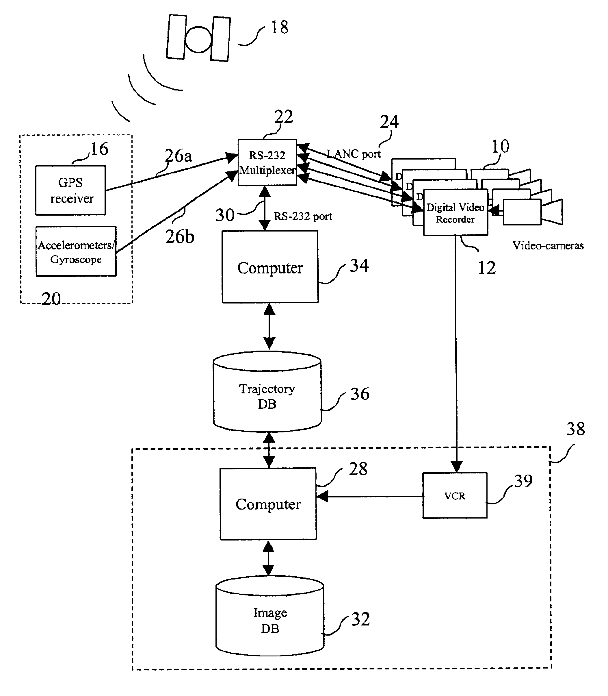
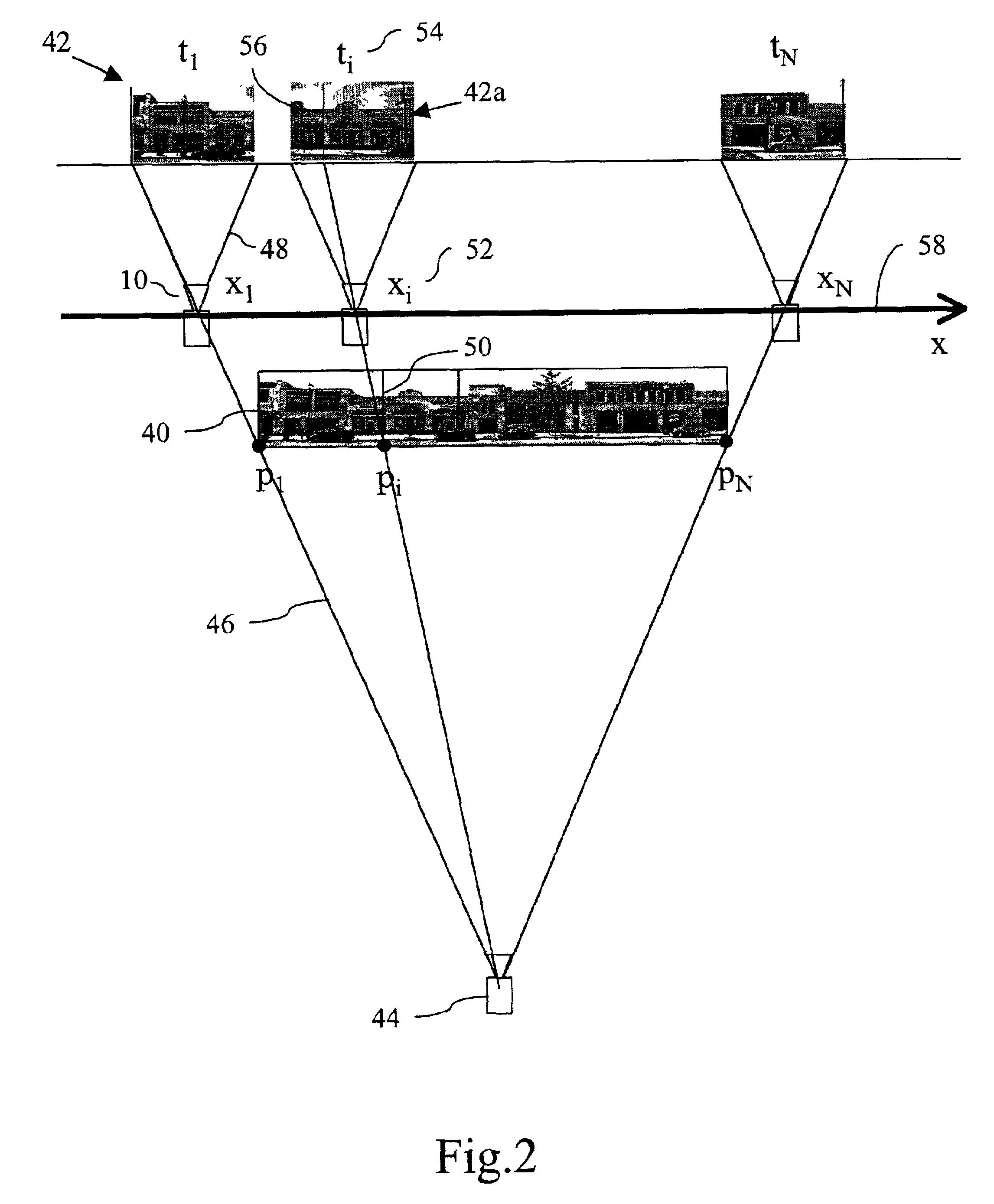
[0032]FIG. 1 is a schematic block diagram of a data acquisition and processing system for acquiring and processing image and position data used to create composite images of a geographic location. The composite images are created by synthesizing individual image frames acquired by a video camera moving through the location and filming the objects in its view. The composite images may depict on urban scene including the streets and structures of an entire city, state, or country. The composite images may also depict other locales such as a zoo, national park, or the inside of a museum, allowing a user to visually navigate the locale.

[0033]The data acquisition and processing system includes one or more image recording devices preferably taking the form of digital video cameras 10 moving along a trajectory / path and recording images on the trajectory on digital videotapes 12. Other types of acquisition devices may also be used in combination to, or in lieu of, the digital cameras 10, su...


PUM


Abstract

A system and method synthesizing images of a locale to generate a composite image that provide a panoramic view of the locale. A video camera moves along a street recording images of objects along the street. A GPS receiver and inertial navigation system provide the position of the camera as the images are being recorded. The images are indexed with the position data provided by the GPS receiver and inertial navigation system. The composite image is created on a column-by-column basis by determining which of the acquired images contains the desired pixel column, extracting the pixels associated with the column, and stacking the columns side by side. The composite images are stored in an image database and associated with a street name and number range of the street being depicted in the image. The image database covers a substantial amount of a geographic area allowing a user to visually navigate the area from a user terminal.

Description

CROSS-REFERENCE TO RELATED APPLICATIONS[0001]This application claims the benefit of U.S. provisional application entitled SYTEM FOR CREATING AND USING A VISUAL RECORD OF A GEOGRAPHIC LOCATION COUPLED WITH POSITION INFORMATION, Provisional Application No. 60 / 238,490, filed on Oct. 6, 2000 the content of which is incorporated herein by reference.FIELD OF THE INVENTION[0002]This invention relates to visual databases, specifically to the creation and utilization of visual databases of geographic locations.BACKGROUND OF THE INVENTION[0003]There exist methods in the prior art for creating visual databases of geographic locations. However, such databases are of limited use due to the method of acquiring the imagery as well as the kind of imagery acquired. One particular method involves the taking of individual photographs of the location and electronically pasting the photographs on a polygonal mesh that provide the framework for a three-dimensional (3D) rendering of the location. This met...

Claims


Application Information

Patent Timeline
Patent Type & Authority Patents(United States)
IPC IPC(8): G06T3/40H04N1/387H04N13/02
CPCG01C11/02G01C21/00G06F17/30241H04N1/3876G06T3/4038H04N5/77G06F16/29G01C21/387G01C21/3848
Inventor DI BERNARDO, ENRICOGONCALVES, LUIS F.
Owner VEDERI
Why Eureka
Try Eureka