
Method and apparatus for automatically collecting terrain source data for display during flight simulation

a technology of automatic collection and terrain source data, applied in the field of flight simulation, can solve the problems of time-consuming process, easy errors, and time-consuming process of searching, collecting and assimilating terrain source data, and achieve the effect of efficiently generating a terrain model and improving the realistic appearance of the resulting terrain model

Inactive Publication Date: 2005-06-28
THE BOEING CO
View PDF26 Cites 14 Cited by
  • Summary
  • Abstract
  • Description
  • Claims
  • Application Information

AI Technical Summary

Benefits of technology

The present invention provides a method and apparatus for automatically generating a terrain model for display during flight simulation. This method and apparatus allow for more efficient and accurate terrain model generation, as it requires less manual participation than conventional techniques. The apparatus includes a mission profiler for automatically determining the area containing the mission route for which terrain source data is required, and a search engine for automatically collecting the terrain source data. The processed terrain source data is then compiled to create a terrain model for display during flight simulation. The resulting terrain model should be of the highest quality, as the most acceptable terrain source data is collected and compiled to create the terrain model. The terrain model may also be partially based upon project source data to further improve its realistic appearance.

Problems solved by technology

As will be apparent, the determination of the area for which terrain source data is required and the respective resolution of each region within that area is not only a time-consuming task, but is also prone to errors.
However, the terrain model designer oftentimes must collect additional terrain source data for areas along the mission route for which no terrain source data is locally stored.
As will be apparent, the process of searching, collecting and assimilating the terrain source data can also be a time-consuming process.
While the terrain model that is necessary to simulate the mission to be flown by the pilot can be constructed in the manner described above, the manual process of collecting and processing the terrain source data and constructing the terrain model is time-consuming and requires that the terrain model designer have substantial experience.

Method used


Image

  • Method and apparatus for automatically collecting terrain source data for display during flight simulation
  • Method and apparatus for automatically collecting terrain source data for display during flight simulation
  • Method and apparatus for automatically collecting terrain source data for display during flight simulation

Examples


Embodiment Construction

[0029]The present invention now will be described more fully hereinafter with reference to the accompanying drawings, in which preferred embodiments of the invention are shown. This invention may, however, be embodied in many different forms and should not be construed as limited to the embodiments set forth herein; rather, these embodiments are provided so that this disclosure will be thorough and complete, and will fully convey the scope of the invention to those skilled in the art. Like numbers refer to like elements throughout.

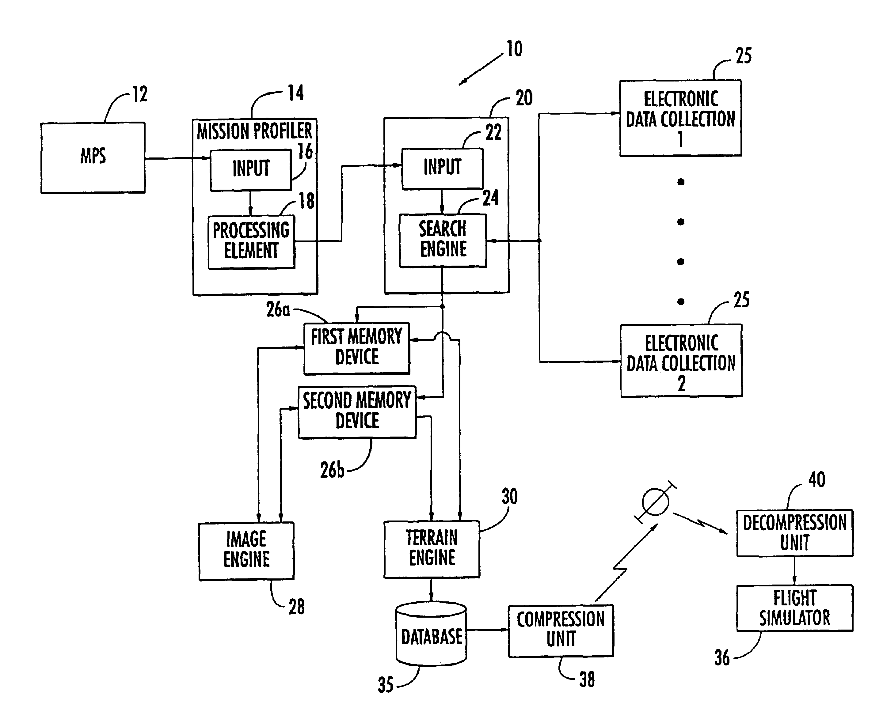
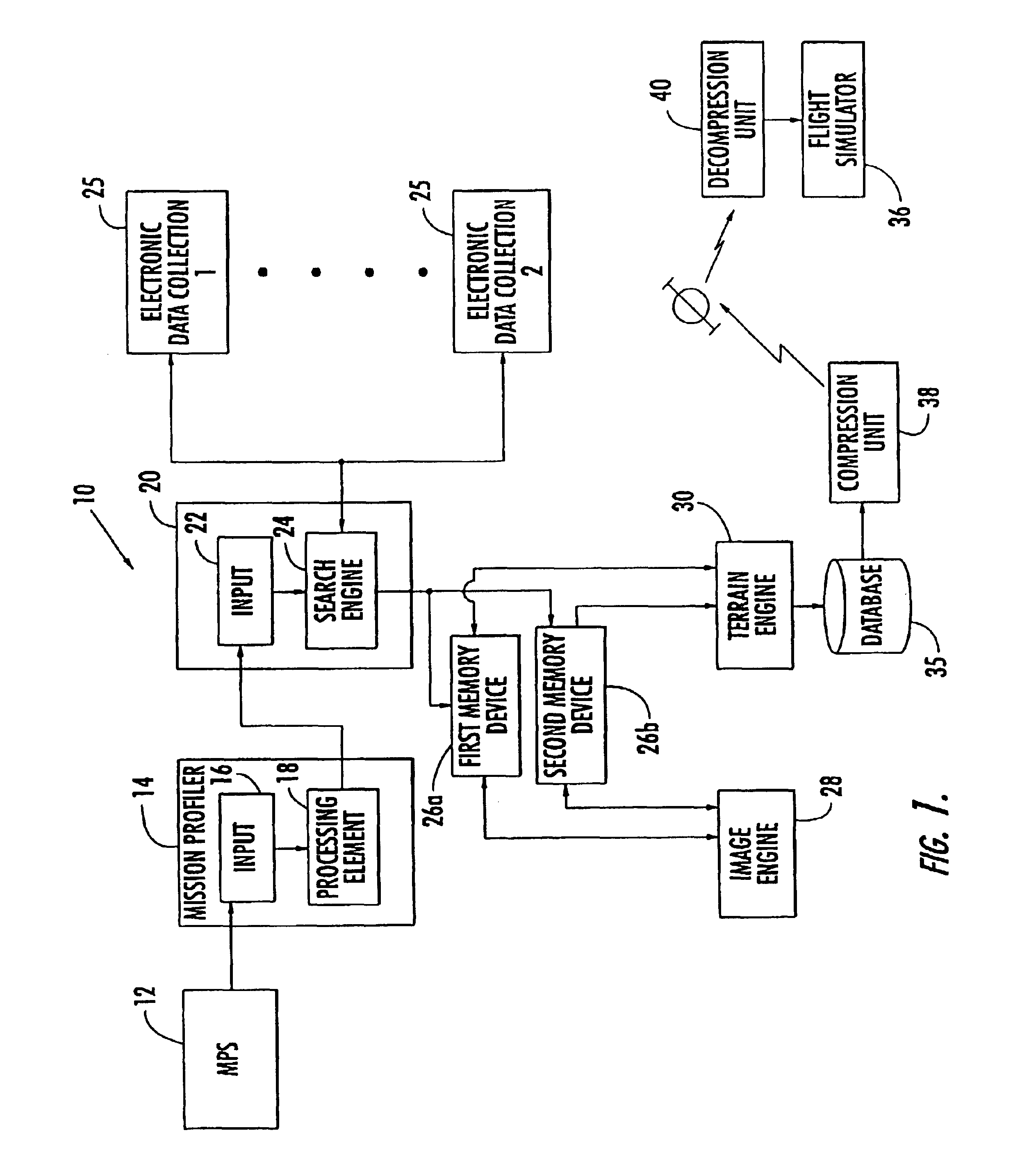
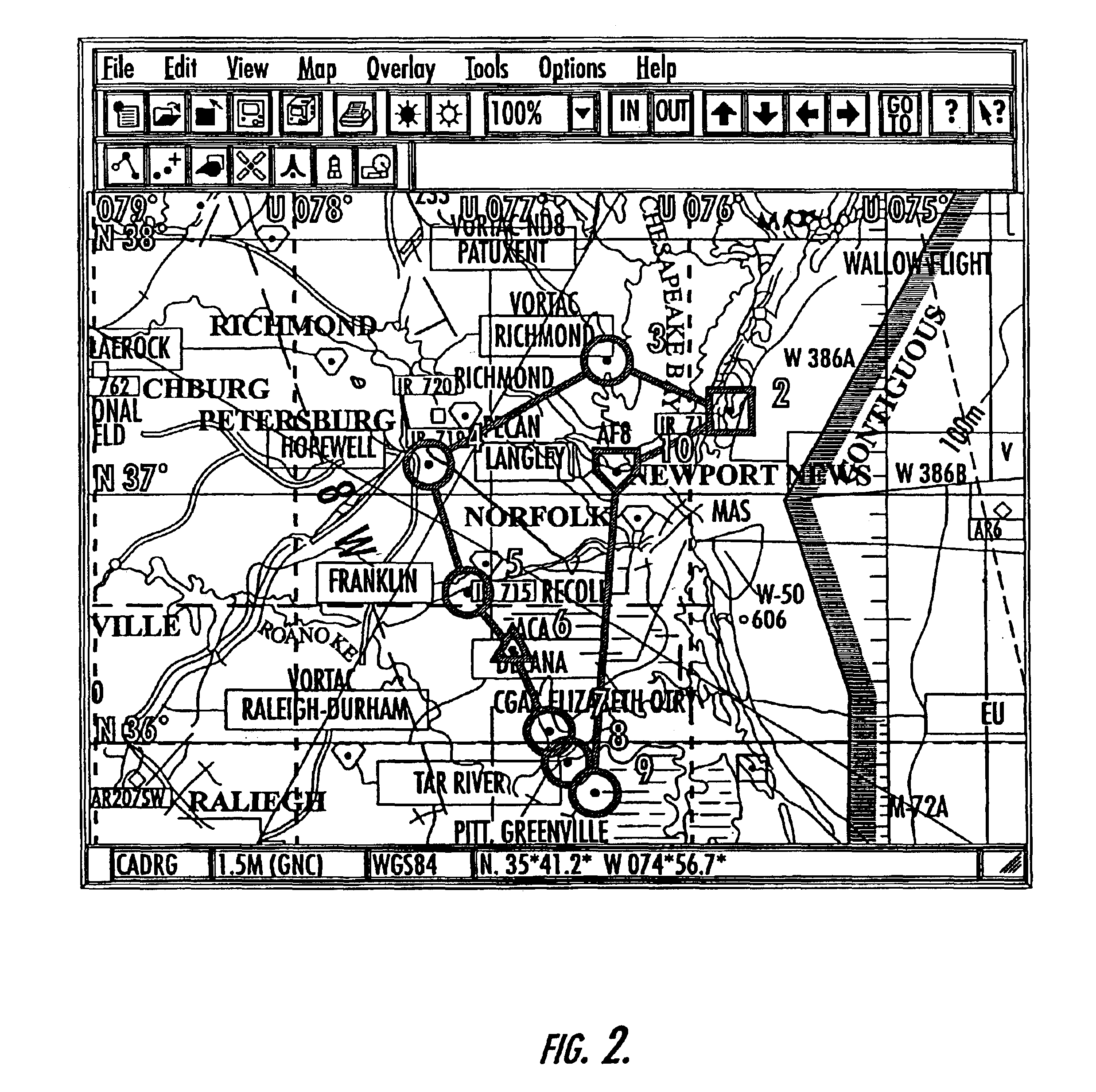
[0030]Referring now to FIG. 1, an apparatus 10 for automatically generating a terrain model for display during a simulated flight along a predefined mission route is depicted. Although the upcoming flight to be simulated will be consistently referred to as a mission, the upcoming flight need not necessarily be a military exercise, but can be a commercial flight or a flight taken for other reasons, such as pleasure. The mission route can be defined in a var...


PUM


Abstract

A method and apparatus are provided for automatically generating a terrain model for display during a simulated flight along a predefined mission route. The apparatus includes a mission profiler that automatically determines the area containing the mission route for which the terrain source data is required and the respective resolution of different regions within the area. The apparatus also includes an apparatus for automatically collecting the terrain source data including a search engine for automatically searching electronic collections of terrain source data to identify terrain source data covering the area containing the mission route. The apparatus also includes an image engine for processing the terrain source data into one or more predefined formats and a terrain engine for automatically compiling the processed data to create a terrain model for display during flight simulation.

Description

CROSS-REFERENCE TO RELATED APPLICATIONS[0001]This application is a divisional of U.S. application Ser. No. 09 / 942.179. filed Aug. 29, 2001. which is hereby incorporated herein in its entirety by reference.FIELD OF THE INVENTION[0002]The present invention relates generally to methods and apparatus associated with flight simulation and, more particularly, to methods and apparatus for generating a terrain model for display during flight simulation.BACKGROUND OF THE INVENTION[0003]Pilots frequently wish to simulate a mission prior to actually flying the mission. By simulating the mission, a pilot can become familiar with the mission route and can either avoid or prepare in advance for any portions of the mission that may require special effort or attention. In order to simulate a mission route, a pilot initially defines the mission route, such as by means of a mission planning system (MPS) or the like. As known to those skilled in the art, a mission planning system receives input from a...

Claims


Application Information

Patent Timeline
Patent Type & Authority Patents(United States)
IPC IPC(8): G09B9/08G09B9/02
CPCG09B9/085
Inventor LECHNER, ROBERT J.
Owner THE BOEING CO
Learn More