System and method for synchronizing raster and vector map images

a vector and map image technology, applied in the field of graphic image manipulation, can solve the problems of inpracticality, inconvenient and expensive conversion of all of the information on paper maps to digital vector format, etc., and achieve the effect of improving the manipulation of graphic images

Inactive Publication Date: 2006-12-12
SOURCEPROSE CORP
View PDF121 Cites 31 Cited by
  • Summary
  • Abstract
  • Description
  • Claims
  • Application Information

AI Technical Summary

Benefits of technology

[0011]It is therefore one object of the present invention to provide improved graphic image manipulations.
[0012]It is another object of the present invention to provide improved manipulation of map images.
[0013]It is yet another object of the present invention to provide an improved system and method for coordinating the manipulation of multiple map images displayed on a data processing system.

Problems solved by technology

It is very expensive and time consuming to convert all of the information on these paper maps over to a digital vector format.
In many cases the scope and expense of such conversions renders them completely impractical.
However, even when a complete conversion to digital vector-based format is not possible, it is still possible to obtain some of the benefits of computerized map systems, first by converting the paper maps to digital raster maps by digitally scanning them, and then by georeferencing the raster image.

Method used


Image

  • System and method for synchronizing raster and vector map images
  • System and method for synchronizing raster and vector map images
  • System and method for synchronizing raster and vector map images

Examples


Embodiment Construction

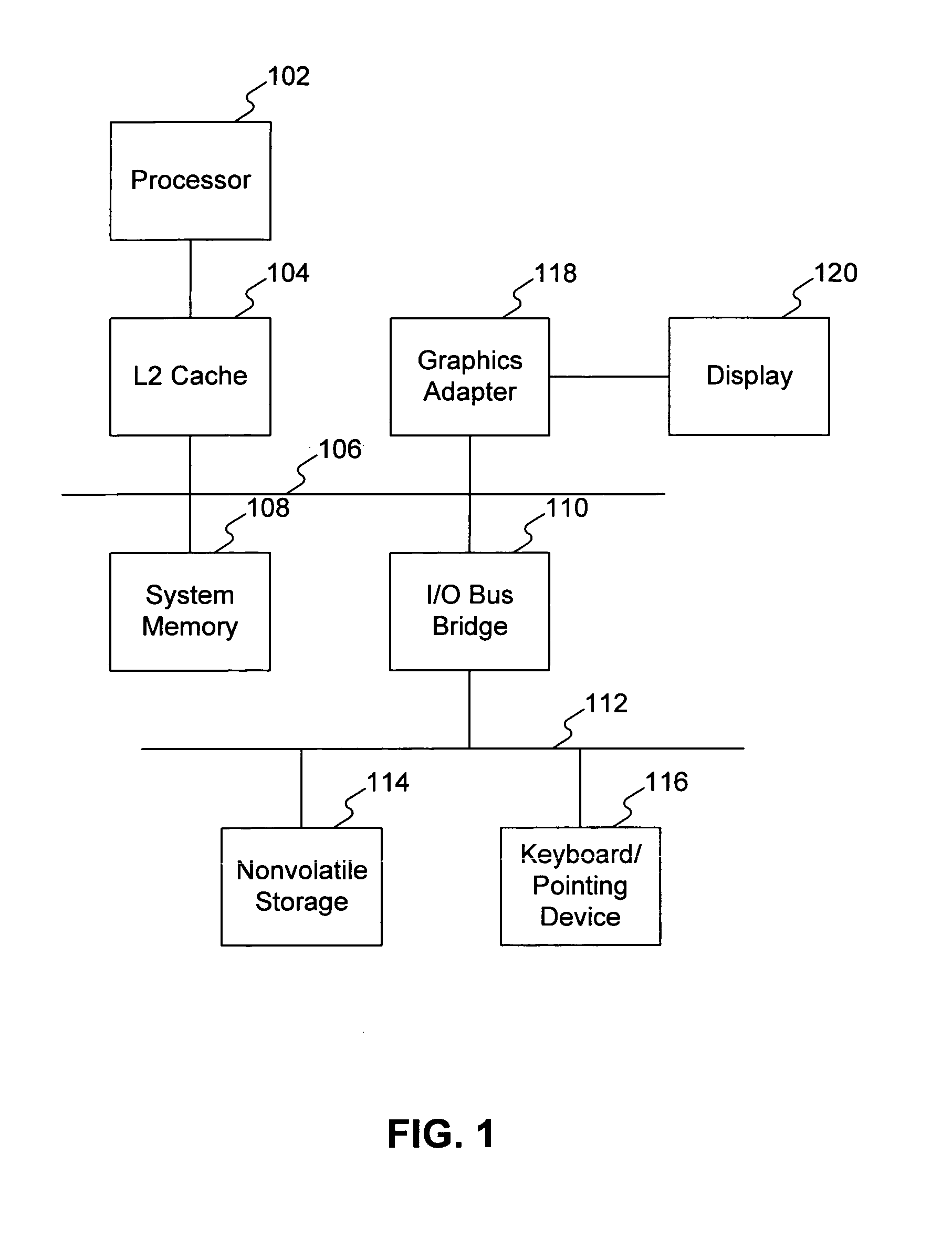
[0022]With reference now to the figures, and in particular with reference to FIG. 1, a block diagram of a data processing system in which a preferred embodiment of the present invention may be implemented is depicted. Data processing system 100 includes processor 102 and associated L2 Cache 104, which in the exemplary embodiment is connected in turn to a system bus 106. System memory 108 is connected to system bus 106, and may be read from and written to by processor 102.

[0023]Also connected to system bus 106 is I / O bus bridge 110. In the exemplary embodiment, data processing system 100 includes graphics adapter 118 connected to bus 106, receiving user interface information for display 120. Peripheral devices such as nonvolatile storage 114, which may be a hard disk drive, and keyboard / pointing device 116, which may include a conventional mouse, a trackball, or the like, are connected to I / O bus 112.

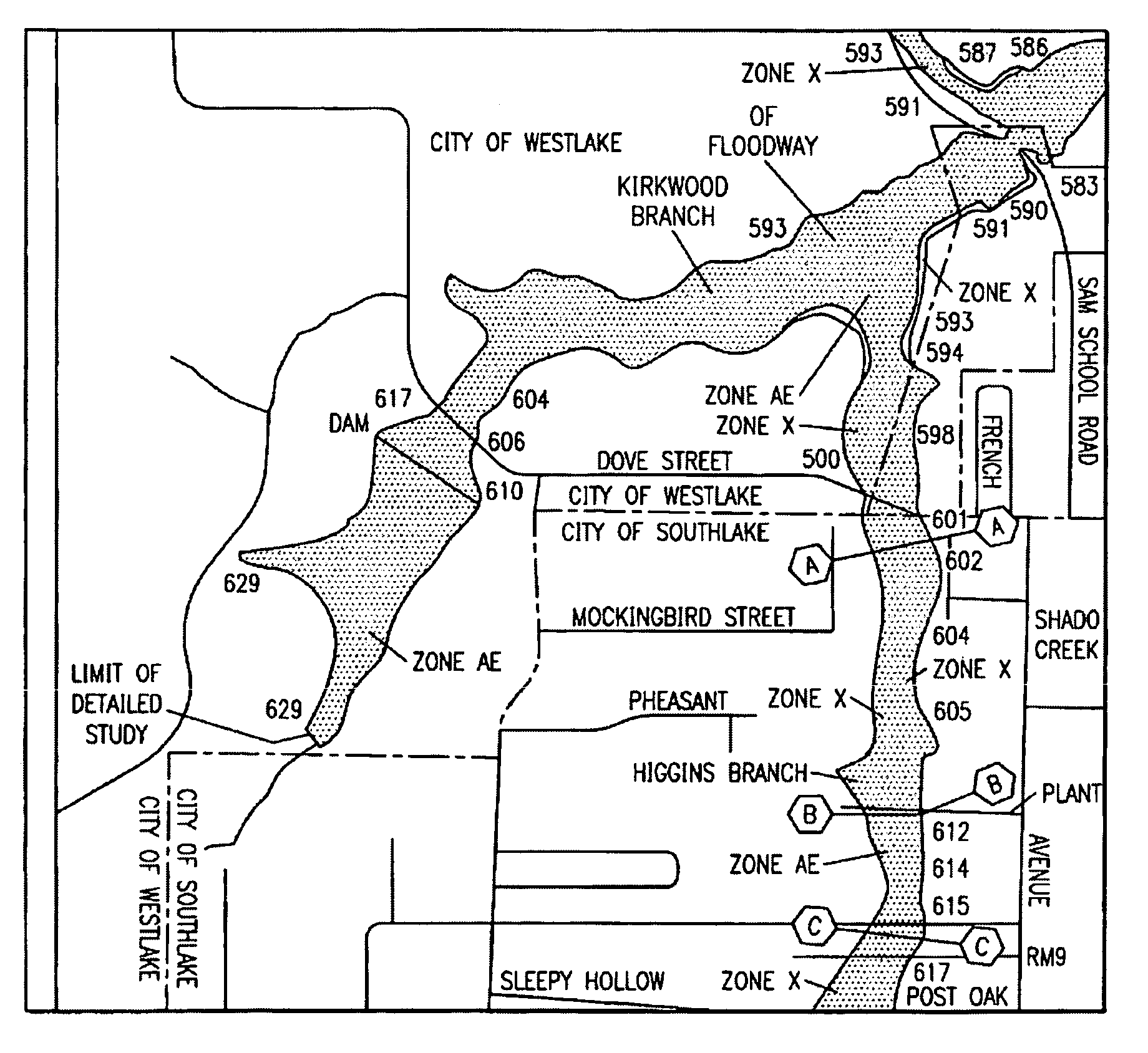
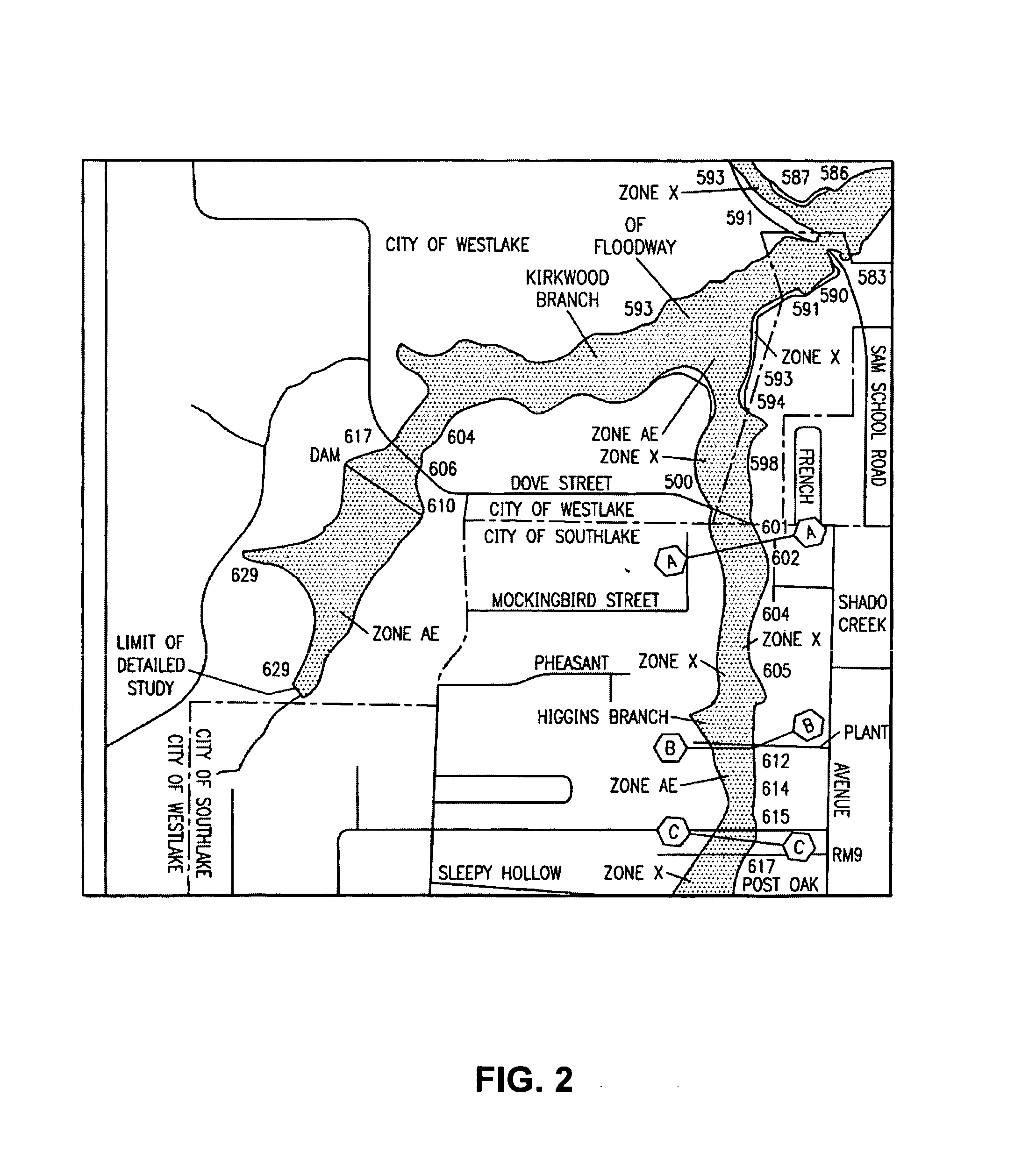
[0024]The exemplary embodiment shown in FIG. 1 is provided solely for the purposes o...


PUM


Abstract

A system and method for coordinated manipulation of multiple displayed maps, even when the maps use different internal coordinate systems. According to this embodiment, each map image to be displayed is first georeferenced, to provide a set of conversion functions between each map's internal coordinate system and a geographic coordinate system, which is latitude / longitude in the preferred embodiment. After this is done, any point on each map can be referenced using the geographic coordinate set. Since this is the case, the maps can now be manipulated, edited, and annotated in a synchronized manner, by defining the manipulations in terms of the geographic coordinate system, and using the georeferencing functions to translate the manipulation to each map's internal coordinate system.

Description

BACKGROUND OF THE INVENTION[0001]1. Technical Field[0002]The present invention generally relates to graphic image manipulations and in particular to manipulation of map images. Still more particularly, the present invention relates to the coordinating the manipulation of multiple map images displayed on a data processing system.[0003]2. Description of the Related Art[0004]Modern geographic information systems normally make use of digital vector-based map information. However, a vast legacy of paper-based map information exists. It is very expensive and time consuming to convert all of the information on these paper maps over to a digital vector format. In many cases the scope and expense of such conversions renders them completely impractical. However, even when a complete conversion to digital vector-based format is not possible, it is still possible to obtain some of the benefits of computerized map systems, first by converting the paper maps to digital raster maps by digitally sc...

Claims


Application Information

Patent Timeline
Patent Type & Authority Patents(United States)
IPC IPC(8): G09G5/12G09G5/14G06T17/05G09B29/10
CPCG06T17/05G09B29/102
Inventor HOWARD, JOHN WILLARDSCOTT, DAN MARTINHIGGINS, DARIN WAYNE
Owner SOURCEPROSE CORP
Why Eureka
Try Eureka