Hiking staff, ski pole, or boat paddle, with integrated topographical representations of trails and or terrain

a topographical representation and hiking pole technology, applied in the field of navigational aids, can solve the problems of inability to consult a map, inconvenient and inefficient use of maps, and universally despised maps for their inherent and perplexing resistance to refolding, so as to facilitate accurately design and manufacture the complex geometry of this invention, the effect of easy extrusion in almost any cross-section

Inactive Publication Date: 2007-08-28
SUTULA JR DANIEL P
View PDF15 Cites 57 Cited by
  • Summary
  • Abstract
  • Description
  • Claims
  • Application Information

AI Technical Summary

Benefits of technology

[0020]In the preferred embodiment, the elevations are contoured from an offset axis to the centerline of the shaft. As a result the vulnerable peaks of the 3-D topology intercept with a solid plane. This is a significant advantage in staffs constructed from material relatively soft and weak materials like some woods and plastics. The 3-D peaks which would otherwise be susceptible to abrasion, denting, or breakage are thus effectively shrouded by solid edges of the shaft. The resulting plane from which the mountains protrude has the effect of represent the background of a sky. Similarly, the solid straight edge provides a frame of reference that is extremely useful in the visualization of the elevation. This embodiment by forming the 3-D topology from the edged of the model the elevations intercepts the plane of a generally circular staff at varying degrees of tangency. The higher the elevation, the smaller the differential between the tangent angle and the offset intercept. As a result the length of the edge formed by the intercept is non-linearly disproportional to the elevation. The effect is that the high points appear higher and the low points appear lower. The planar surface could representing the sky would simultaneously shroud the peaks.
[0038]A suitably strong and durable staff could be efficiently produced from tubular metal in a process such as hydroforming or explosive forming wherein a small diameter ductile metal tube is internally pressurized and expanded to fill a complex 3-D cavity. Alternately, a larger diameter tube could be externally shrunk down or formed over a mandrel. Suitable processes again include hydroforming, explosive forming, and Magneforming wherein electrical energy is use to generate the forming force.

Problems solved by technology

Unfortunately, maps are somewhat inconvenient and inefficient to use, as they typically require unpacking, unfolding, refolding, and repacking.
In fact, maps are universally despised for their inherent and perplexing resistance to refolding.
Some navigational errors result from failures to consult a map attributable to the inconvenience.
Moreover, many people are incapable of, or experience great difficulty in comprehending 2-D graphical information or cartographic data presented on a flat map.
This process is often difficult time consuming and subject to interpretation and translation errors.
Unfortunately, GPS systems are small computers and thus, some people are intimidated or otherwise incapable of operating them.
GPS systems displays are presently limited to 2-D flat screen LCDs that provide only minimal 3-D perspective.
The typical slab type model format is an inefficient means of representing the topology of particular routes or trails due to the fact that much of the information off of the trail is generally not significant.
Similarly, small-scale 3-D trail models are not particularly viable as they are volumetrically inefficient and inconvenient to pack, carry, and access.
Moreover, rivers are often wind back and forth through areas of remarkably similarity appearance making position and progress difficult to monitor.
Submerged obstacles can be dangerous and are often impossible to see from the surface.
It is often impossible or imprudent to let go of a paddle in order to access a conventional chart.
Cold weather conditions and heavy garments such as gloves make access to maps exceedingly inconvenient.
But the basic utility of these devices has not advanced appreciably.

Method used


Image

  • Hiking staff, ski pole, or boat paddle, with integrated topographical representations of trails and or terrain
  • Hiking staff, ski pole, or boat paddle, with integrated topographical representations of trails and or terrain
  • Hiking staff, ski pole, or boat paddle, with integrated topographical representations of trails and or terrain

Examples


Embodiment Construction

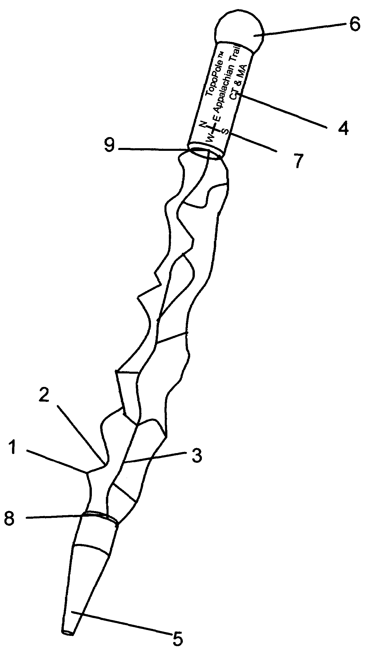
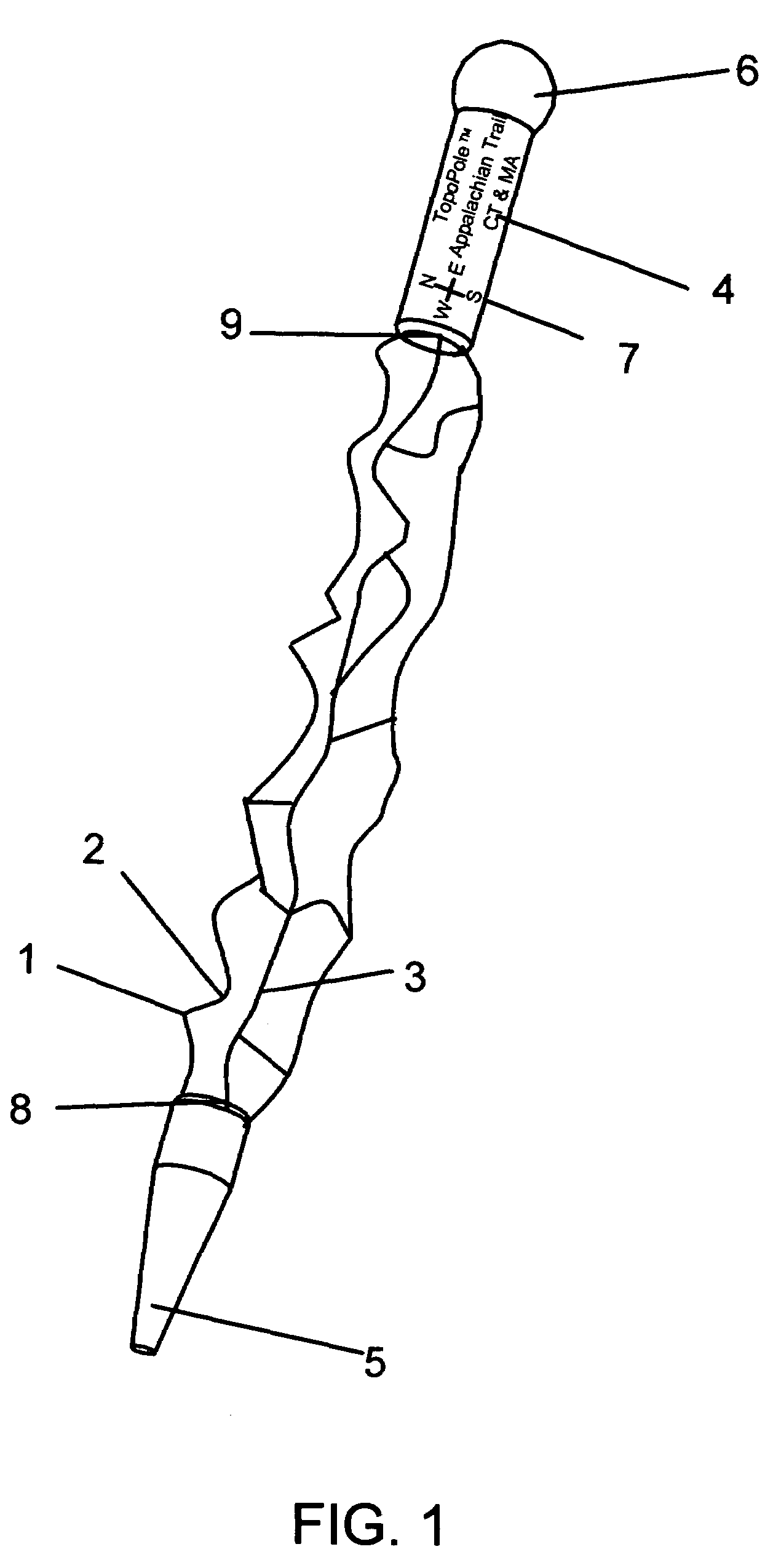
[0064]FIG. 1 shows a perspective view of a hiking staff, the exterior of which features 3-D contoured topology superimposed with 2-D trail and map data in accordance with the preferred embodiment of this invention. The highest elevations or mountain peaks are represented as protrusions 1. In contrast the lowest elevations are 2 represented by valleys 2. Trails 3, natural features, and pertinent information may be superimposed onto the 3-D surfaces. Pertinent statistics 4 may also be labeled on the staff. Other portions of the staff such as the point 5 and handle 6 may be of conventional form. Other information such as a directional index 7 and start and stop labels 8 and 9 may be included.

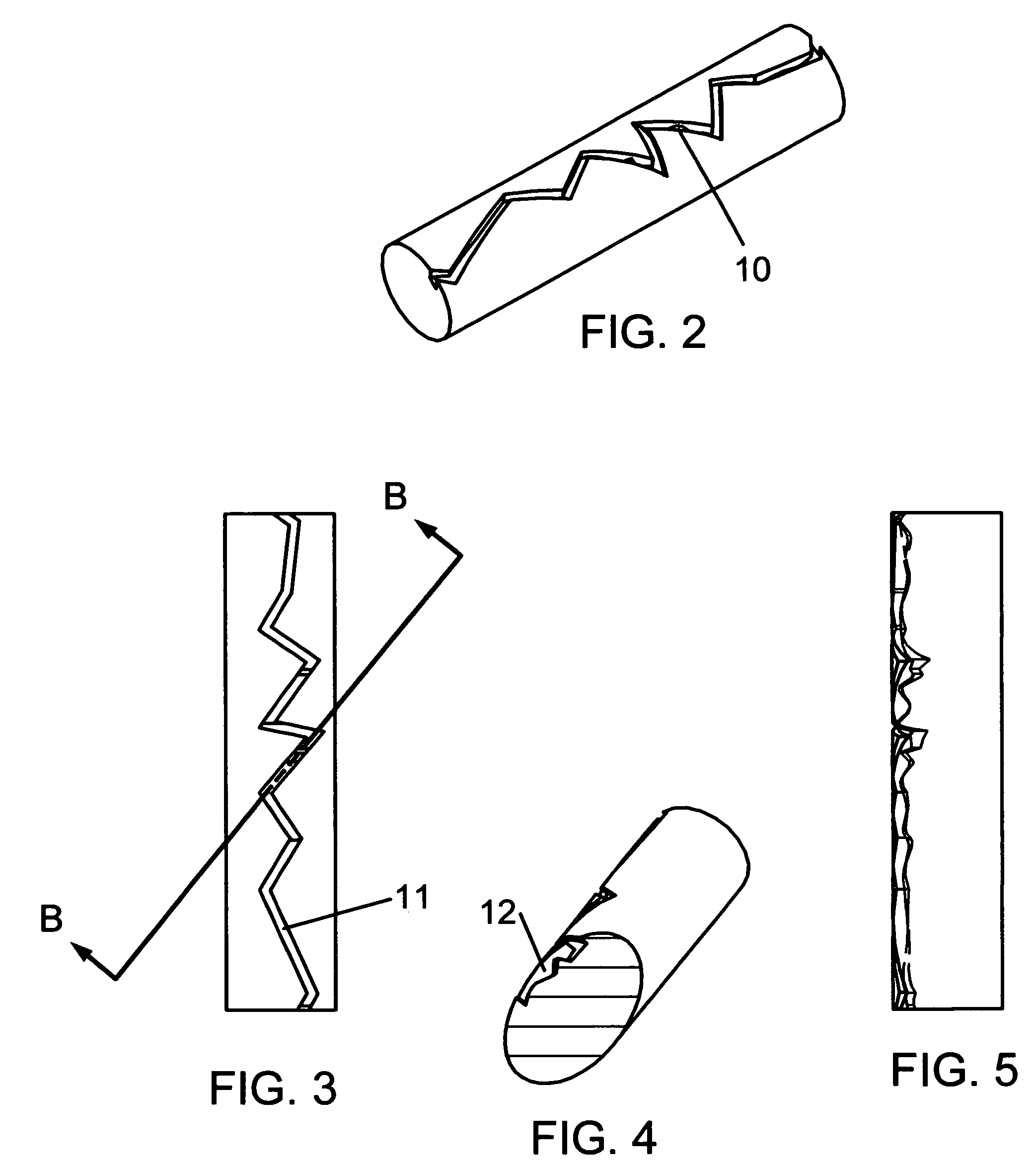
[0065]FIG. 2 shows a hiking staff in accordance with another embodiment of the invention in which a 3-D groove 10 representing the trail has been mapped and wrapped onto the surface of the staff with the groove depth representing the elevation and contour of the trail. FIG. 3 shows the trail groove...


PUM


Abstract

A navigational aide in the form of a physical model that may be integrated with conventional expedition equipment. The preferred embodiment comprises a hiking staff (5, 6) containing 2-D map data (3) and or 3-D topographical representations (1, 2) corresponding with specific geographic regions and or features. The 3-D surfaces may be sculpted about and along the model. Alternately, cross-sectional elevation profiles of routes may be presented in the form of a 3-D sculpted grooves or flutes along, about, and or around the shaft. A variety of configurations are presented for the purpose of maximizing the effective sculptable areas or edges, and to provide a shrouding effect for the protruding peaks that would otherwise be vulnerable to deformation and uncomfortable to grip. The 3-D elevations may be exaggerated to visually accentuate changes in elevation. Features such as trails may be represented as grooves to facilitate marking progress and position. 2-D cartographic data (7,8,9) may also be presented along with the 3-D data or alone as a mounted map. In an alternate embodiment, the invention comprises a toy for children, inspiring learning imagination and adventurous play. Several methods and materials for both computerized and conventional design and manufacturing are provided. The novel aspects of this invention may be incorporated in the original equipment manufacture, modification of existing equipment, and accessories for attachment to conventional equipment.

Description

[0001]The inventor hereby claims the priority filing benefits resulting from coresponding Provisional Patent Application No. 60 / 281,060 filed Apr. 3, 2001BACKGROUND OF THE INVENTION[0002]1. Field of the Invention[0003]The present invention relates to a navigational aide in the form of physical model conveniently embodied in a generally long and slender shape, comprising three-dimensional (3-D) topographical representations and or two-dimensional (2-D) cartographic data corresponding with geographic regions and features such as mountains, rivers, shorelines, and trails. The preferred embodiment of the invention comprises the navigational aid integrated with a hiking staff. Alternate embodiments include boat paddles, ski poles, and universal attachable accessories and grips for these and other application. Another embodiment, the invention comprises a toy for children, inspiring learning imagination and adventurous play. A variety of geometric configurations are presented for the purp...

Claims


Application Information

Patent Timeline
Patent Type & Authority Patents(United States)
IPC IPC(8): G09B29/00G09B25/06G09B25/08
CPCG09B25/06G09B25/08G09B29/00B33Y50/00
Inventor SUTULA, JR., DANIEL P.
Owner SUTULA JR DANIEL P
Why Eureka
Try Eureka