Space based change detection using common ground track constellations

a technology of space-based change detection and common ground track, which is applied in the field of satellite constellations, can solve the problems of most satellite systems not being designed, distortion and blur of change detection images, and achieve the effect of reducing blurring and distortion of images, and reducing the number of satellites

Inactive Publication Date: 2007-09-18
NORTHROP GRUMMAN SYST CORP
View PDF14 Cites 43 Cited by
  • Summary
  • Abstract
  • Description
  • Claims
  • Application Information

AI Technical Summary

Benefits of technology

[0020]It is a further aspect of the present invention to provide sharpened change detection images having minimal image blurring and distortion from a space based apparatus.
[0021]Still another aspect of the present invention is to provide constellation of satellites organized along common ground tracks with reduced numbers due to tiling of the satellites.

Problems solved by technology

However, the motion and displacement of the platforms when the images are taken may distort and blur the change detection images.
The problem is that most satellite systems that are used for reconnaissance have not been designed with the object of performing change detection with minimal blurring and distortion.
However, a typical problem with satellites organized into orbital planes, either the same orbital plane or different orbital planes, is that the ground tracks / paths, i.e., the movement of beams across the surface of the earth, are typically not common.
This type of configuration is motivated in part by the larger costs associated with placing satellites into different orbital planes.
However, such Walker configurations are sub-optimal configurations because they fail to provide minimal satellite counts and high revisit rates to particular regions on the earth.
As a result, for Walker orbits, the ground tracks / paths of the collection of satellites are seldom common.
When these images are actually taken of a common region of the earth, blurring and distortion of the images will occur because the two satellites follow different ground tracks / paths.
However, even when this morphing technique is performed, errors still remain in the images due to the fact that the images are of three-dimensional regions, instead of two-dimensional regions.
In other words, the stretching and twisting of the images by using the morphing technique may compensate for the blurring and distortion of two-dimensional images but does not adequately compensate for three-dimensional images which are typically taken by satellites.

Method used


Image

  • Space based change detection using common ground track constellations
  • Space based change detection using common ground track constellations
  • Space based change detection using common ground track constellations

Examples


example 1

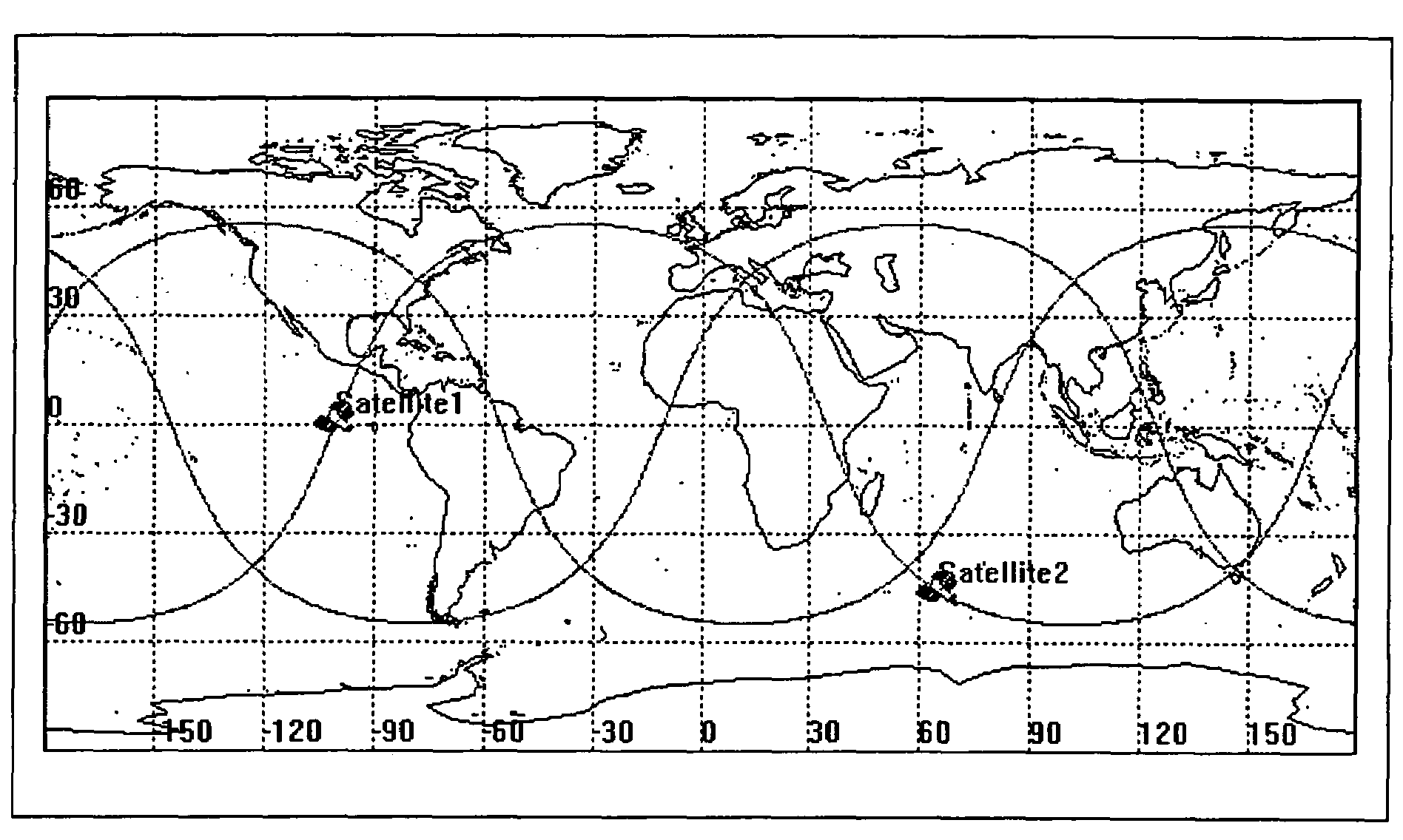
[0057]In addressing the problems noted above, an example involving two satellites orbiting in a common plane (See FIG. 3) will be used. For this example, the ground tracks of the two satellites are different, and images taken from each of the satellites can not be accurately combined to form a change detection image without performing some sort of image processing to remove the distortion and blurring.

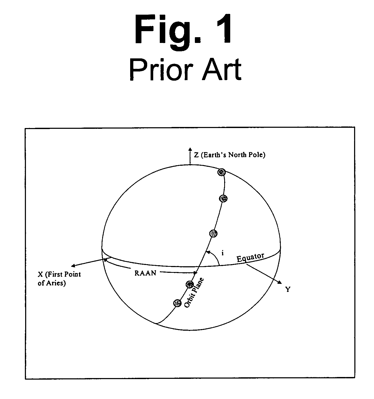
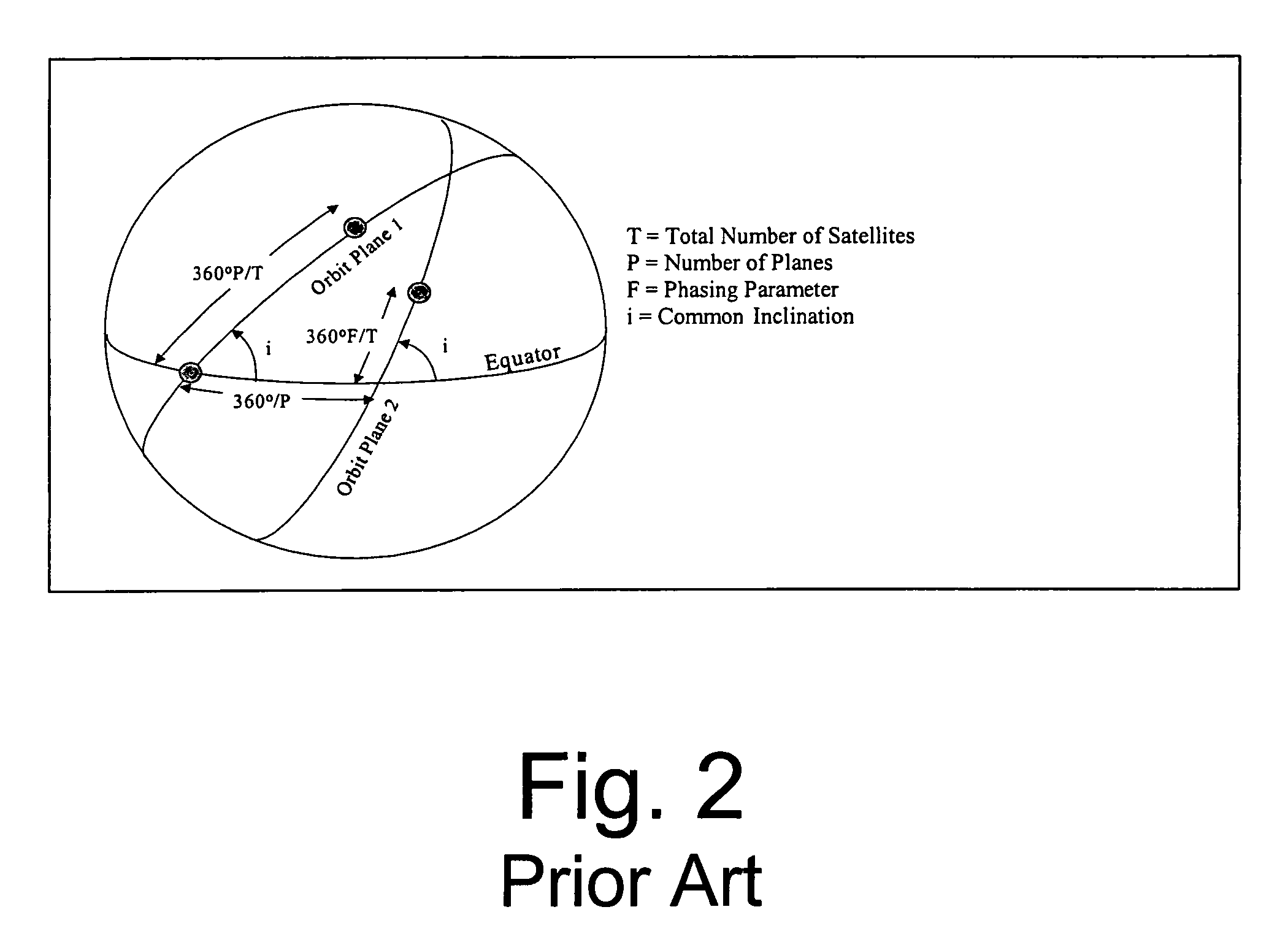
[0058]FIG. 5 illustrates an example of a change detection orbit comparable to FIG. 3, yet FIG. 5 is designed according to the approach presented in this disclosure. For instance, as shown in FIG. 5, satellite 1 is the same as FIG. 3. However, satellite 2 is placed in a separate plane from satellite 1. This separate plane for satellite 2 has a right ascension of the ascending node (RAAN) of 300 degrees relative to the first satellite while the phasing angle between the two satellites is set at 240 degrees. The phasing angle defines the difference in angle between the two satellites. The...

example 2

[0062]In yet another example, a string of satellites that provides contiguous coverage over any point on earth for some predefined period of time is designed. The specification for this string of satellites is determined in the following manner.

[0063]First, the radius of coverage, ro, is determined for an individual satellite. FIG. 6 illustrates the geometry for this situation.

[0064]From this geometry, one finds that the coverage radius is given by:

ro=Re{π / 2−φ−a sin [(Re / a)cos φ]}  (6)

[0065]The coverage radius is formulated in terms of the driving requirements: the minimum graze angle, φ, and the satellite radius, a, with respect to the center of the earth.

[0066]Second, the spacing between satellites, d, and the width of the contiguous coverage region, w, is determined by optimizing the width with respect to the total area coverage. Using a flat earth model (see FIG. 7), the optimal angle, γ, from the center of one satellite's coverage region to the edge of the overlapping coverage ...


PUM


Abstract

A new approach for designing satellite constellations whereby each satellite follows a common ground track is being proposed for performing high-precision change detection imagery for long periods of time. By precisely prescribing the orbital parameters, i.e., the relationship between the right ascension of the ascending nodes (RAAN) and the phase angle difference between successive satellites, for example, sharpened change detection images may be taken from successive satellites in the constellation without the need to process out blurring by any special image re-working software. The relationship between the orbital parameters of the satellites is precisely tuned to the earth's rotation rate for the altitude of the satellites. A reduction in the total satellite count is achievable due to tiling the satellite coverage in near optimal arrangements. Such high-precision change detection imaging by successive satellites in orbit around the earth is at least useful in the detection of underground facilities activities and the detection of slow moving objects.

Description

CROSS REFERENCE TO RELATED APPLICATION[0001]The present application claims the benefit of U.S. Provisional Patent Application No(s). 60 / 555,298 and 60 / 555,297, both filed on Mar. 23, 2004, the entire contents of both which are hereby incorporated by reference.BACKGROUND OF THE INVENTION[0002]1. Field of the Invention[0003]This invention relates generally to satellite constellations and more particularly to satellite constellations orbiting on common ground tracks for providing enhanced space based change detection.[0004]2. Description of Related Art[0005]A typical method for detecting moving targets, that has been used by intelligence personnel for more than 50 years, is to search for changes in these common images. Change detection, as this process might be referred, allows one to analyze moving targets by examining successive images such synthetic-aperture radar (SAR) or optical images. Also, areas where tunnels or underground bunkers are under construction have been generally loc...

Claims


Application Information

Patent Timeline
Patent Type & Authority Patents(United States)
IPC IPC(8): B64G1/10
CPCB64G1/1021B64G1/1085B64G1/242
Inventor MURPHY, JOHN H.
Owner NORTHROP GRUMMAN SYST CORP
Why Eureka
Try Eureka