Integrated earth formation evaluation method using controlled source electromagnetic survey data and seismic data

a technology of electromagnetic survey and integrated earth formation, which is applied in the field of controlled source electromagnetic surveying, can solve the problems of not being able to distinguish oil-bearing formations using seismic data, limiting the use of f-csem techniques known in the art, and limited to relatively great water depths

Active Publication Date: 2008-02-05
KJT ENTPR
View PDF12 Cites 64 Cited by
  • Summary
  • Abstract
  • Description
  • Claims
  • Application Information

AI Technical Summary

Benefits of technology

[0025]Other aspects and advantages of the invention will be apparent from the following description and the appended claims.

Problems solved by technology

A limitation to f-CSEM techniques known in the art is that they are typically limited to relatively great water depth, on the order of 800-1,000 meters, or a ratio of ocean water depth to subsurface reservoir depth (reservoir depth measured from the sea floor) of greater than about 1.5 to 2.0.
Seismic data are less useful than EM data to distinguish oil-bearing formations because the velocity of seismic energy in oil-bearing rock is substantially similar to that in water-bearing rock.
However, electromagnetic survey data are less useful to distinguish oil bearing formations from gas bearing formations because oil and gas have similar electrical conductivity.
A limitation to applying the technique disclosed in the Frenkel et al.
Because of the different response characteristics, applying joint inversion to obtain a global minimum error function and thus a final model may provide results that are not optimal, or may represent physically impossible subsurface Earth conditions.

Method used


Image

  • Integrated earth formation evaluation method using controlled source electromagnetic survey data and seismic data
  • Integrated earth formation evaluation method using controlled source electromagnetic survey data and seismic data
  • Integrated earth formation evaluation method using controlled source electromagnetic survey data and seismic data

Examples


Embodiment Construction

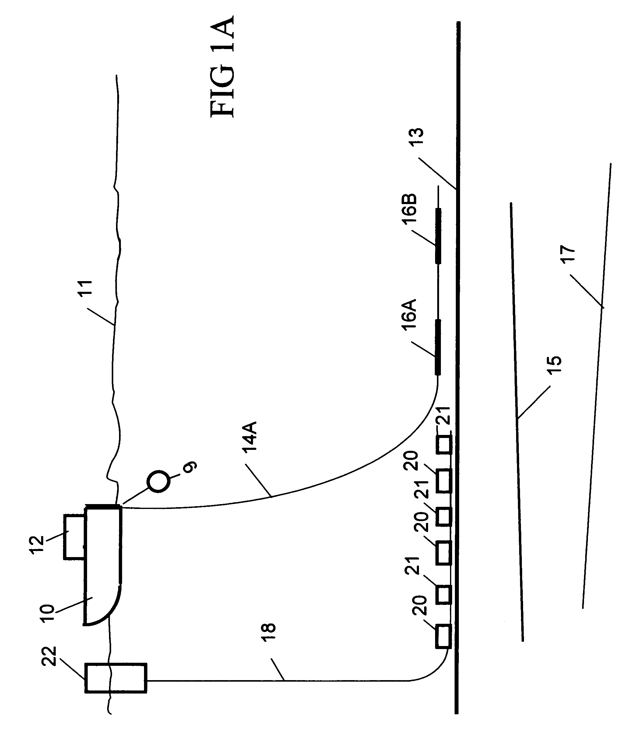
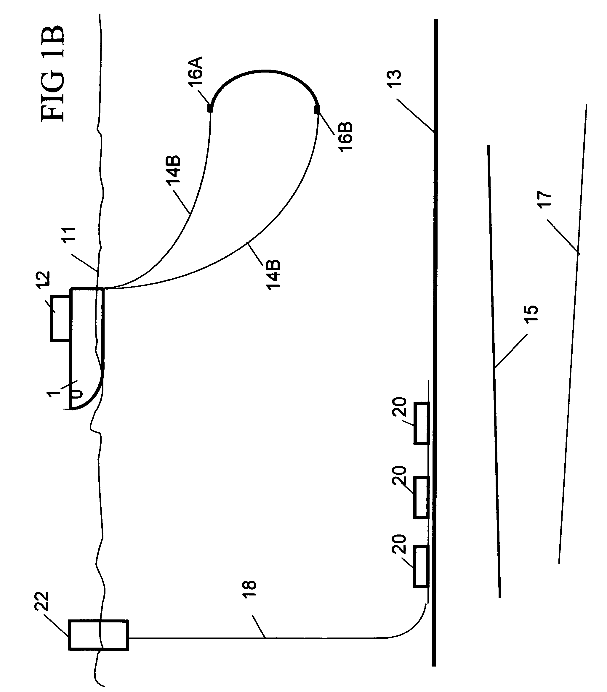
[0034]FIG. 1A shows one embodiment of a marine transient controlled source electromagnetic (t-CSEM) survey system for use with methods according to various aspects of the invention. The system includes a survey vessel 10 that moves in a predetermined pattern along the surface of a body of water 11 such as a lake or the ocean. The vessel 10 includes thereon source actuation, recording and navigation equipment, shown generally at 12 and referred to herein as the “recording system.” The recording system 12 includes a controllable source of electric current used to energize electrodes 16A 16B towed in the water 11 near the bottom 13 thereof to impart an electric field in subsurface formations 15, 17 below the bottom 13 of the water.). It also contains a seismic source 9 The recording system 12 includes instrumentation to determine the geodetic position of the vessel 10 at any time, such as can be performed using global positioning system (GPS) receivers or the like. The recording system...


PUM


Abstract

A method for determining spatial distribution of properties of the Earth's subsurface includes obtaining seismic data over a survey area of the Earth's subsurface. Controlled source electromagnetic survey data are obtained over substantially the same survey area. An initial model of the Earth's subsurface for each of the seismic data and the electromagnetic data is generated. Further data may include gravity, magnetics, seismics any type and borehole data. Each model is optimized on at least one model parameter. Consistency is determined between the models; and the at least one model parameter is adjusted and the optimizing and determining consistency are repeated until the models are consistent. Constraints are successively derived from the data sets and also cross checked against reservoir data where available.

Description

CROSS-REFERENCE TO RELATED APPLICATIONS[0001]Not applicable.STATEMENT REGARDING FEDERALLY SPONSORED RESEARCH OR DEVELOPMENT[0002]Not applicable.BACKGROUND OF THE INVENTION[0003]1. Field of the Invention[0004]The invention relates generally to the field of controlled source electromagnetic surveying. More specifically, the invention relates to methods for interpreting transient electromagnetic surveys along with other petrophysical data such that subsurface features may be more readily identified.[0005]2. Background Art[0006]Electromagnetic geophysical surveying includes “controlled source” electromagnetic surveying. Controlled source electromagnetic surveying includes imparting an electric current or a magnetic field into the Earth's subsurface, and measuring voltages and / or magnetic fields induced in electrodes, antennas and / or magnetometers disposed on or near the Earth's surface or the sea floor. The voltages and / or magnetic fields are induced in response to the electric current ...

Claims


Application Information

Patent Timeline
Patent Type & Authority Patents(United States)
IPC IPC(8): G01V1/28
CPCG01V11/00G01V2210/6163
Inventor STRACK, KURT M.RUETER, HORSTTHOMSEN, LEON A.
Owner KJT ENTPR
Why Eureka
Try Eureka