System and method for determining a location of an emergency call in a sparsely-populated area

a technology of sparsely populated areas and system and methods, applied in emergency connection handling, connection management, instruments, etc., can solve the problems of inability of gps receiver a relatively long time-consuming and laborious process, and inability to determine the location of the caller, etc., to achieve effective triangulation

Active Publication Date: 2009-11-24
NEXTEL COMMUNICATIONS
View PDF11 Cites 12 Cited by
  • Summary
  • Abstract
  • Description
  • Claims
  • Application Information

AI Technical Summary

Problems solved by technology

The GPS technique, however, does have some drawbacks.
For instance, the GPS receiver requires time to “warm up”, and often takes a relatively long time to determine the location of the caller.
Also, there are a number of environments where the GPS receiver is not capable of determining the location of the caller due to, for example, obstructions and / or lack of receiving sufficient number of the GPS satellite signals.
This presents a problem for a sparsely-populated area.

Method used


Image

  • System and method for determining a location of an emergency call in a sparsely-populated area
  • System and method for determining a location of an emergency call in a sparsely-populated area
  • System and method for determining a location of an emergency call in a sparsely-populated area

Examples


Embodiment Construction

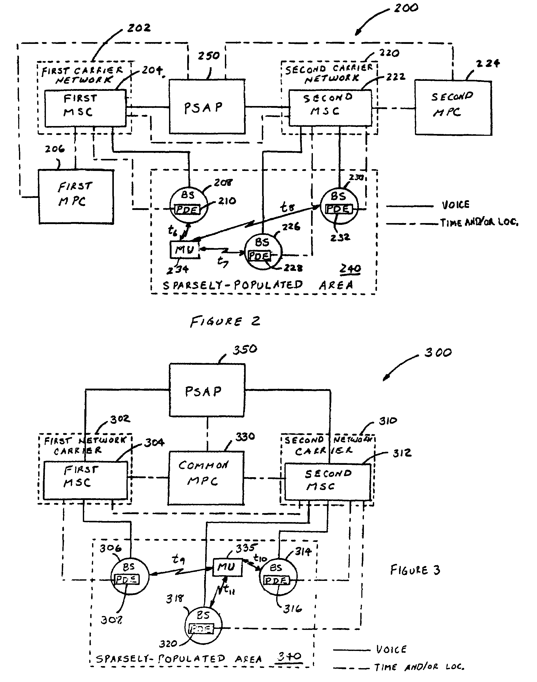
[0034]FIG. 2 illustrates a block diagram of an exemplary wireless communication system 200 in accordance with an embodiment of the invention. In summary, the wireless communication system 200 is characterized in the sharing of PDE resources by two or more different wireless communication carriers in order to provide effective triangulation for locating emergency-calling mobile units (MUs) in a sparsely-populated area. In this example, the triangulation technique used to illustrate this embodiment of the invention is Time Difference of Arrival (TDOA), wherein base site equipment record the time of arrival of the signal received from emergency-calling MUs. It shall be understood that the invention also applies to Angle of Arrival (AOA), Enhanced Observed Time Difference (E-OTD), and other triangulation techniques.

[0035]In particular, the wireless communication system 200 comprises a first carrier network 202 including a first mobile switching center (SC) 204 and possibly other network...


PUM


Abstract

A wireless communication system useful in assisting and locating users of mobile communication units (MUs) with emergency situations. In one embodiment, the system includes position determining equipment (PDE) to generate position data information related to receiving an emergency call request, wherein some of the PDEs are associated with a first wireless carrier and others associated with a second carrier; and a mobile positioning center (MPC) adapted to determine an approximate location of an emergency-calling MU from the position data information received from the PDEs. In another embodiment, the system includes PDEs, wherein at least one is a standalone PDE; and an MPC. In another embodiment, the system includes a mobile switching center (MSC), bases stations restricted to emergency use only, and PDEs associated respectively with the base stations. In another embodiment, the system includes PDEs adapted to transmit position data information to an MPC via a wireless medium.

Description

CROSS-REFERENCE OF RELATED APPLICATIONS[0001]This application claims the benefit of the filing date of Provisional Application 60 / 690,952, entitled “System and Method for Locating Mobile Communication Units,” filed on Jun. 15, 2005, which is incorporated herein by reference. This application is also related to Non-Provisional Application entitled “System and Method for Position Equipment Dusting in Search and Rescue Operations,” filed on Jun. 17, 2005.”FIELD OF THE INVENTION[0002]This invention relates generally to wireless communication systems, and in particular, to a system and method for determining a location of an emergency call in a sparsely-populated area.BACKGROUND OF THE INVENTION[0003]In an emergency situation, a person in distress typically calls a pre-determined telephone number (e.g., 911 in the United States) to obtain assistance with the emergency from a public safety agency (e.g., law enforcement, fire department, medical unit, animal control, etc.). An emergency ca...

Claims


Application Information

Patent Timeline
Patent Type & Authority Patents(United States)
IPC IPC(8): H04M11/04H04W24/00
CPCG01S5/0081G01S5/0205H04W64/00H04M11/04H04W76/007H04W4/22H04W76/50H04W4/90
Inventor LEVITAN, BENJAMIN CHARLES
Owner NEXTEL COMMUNICATIONS
Why Eureka
Try Eureka