Map display device and map display method

a map display and map technology, applied in the direction of traffic control systems, navigation instruments, instruments, etc., can solve the problem of reducing the display contents near the subject vehicle, and achieve the effect of extending the display range and high visibility

Active Publication Date: 2009-12-08
DENSO CORP +1
View PDF21 Cites 10 Cited by
  • Summary
  • Abstract
  • Description
  • Claims
  • Application Information

AI Technical Summary

Benefits of technology

[0006]The present invention has been made in consideration of the foregoing. It is therefore an object of the present invention to provide a map display device, a map display method, a map display program, and a recording medium to record the same program capable of extending a display range and keeping a high level of visibility for display contents near a subject vehicle.

Problems solved by technology

It is impossible to prevent the display contents near the subject vehicle from being reduced while extending the display range.

Method used


Image

  • Map display device and map display method
  • Map display device and map display method
  • Map display device and map display method

Examples


Embodiment Construction

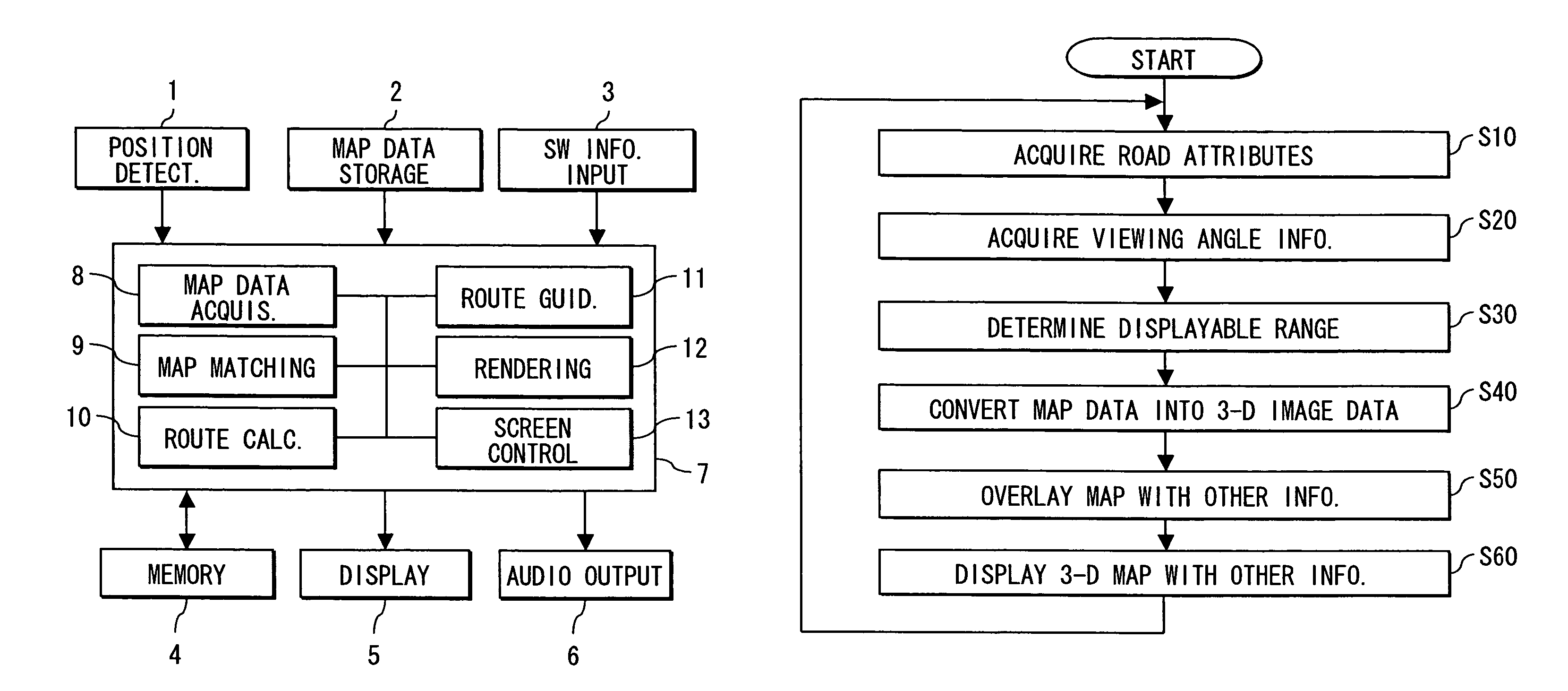
[0019]An embodiment of the present invention will be described in further detail with reference to the accompanying drawings. The embodiment describes an example of realizing the map display device according to the invention as one function of a car navigation apparatus.

[0020]The invention can be embodied not only as one function of the car navigation apparatus. The invention can be also embodied by installing a program for implementing functions of the invention into, for example, other vehicle-mounted terminals, mobile phones, PDAs (Personal Digital Assistants), PCs (Personal Computers), and the like.

[0021]FIG. 1 schematically shows the overall construction of the car navigation apparatus. In FIG. 1, a position detection unit 1 is composed of a GPS (Global Positioning System) receiver, a direction sensor, a gyro sensor, and a vehicle speed sensor (not shown). The position detection unit 1 calculates information about a vehicle's current position. Since the respective sensors have ...


PUM


Abstract

In a map display device, a viewing angle for a three-dimensional road map can be changed horizontally on a screen so that the three-dimensional road map is generated at a standard viewing angle (45°) up to a wide viewing angle (90°). At this time, the viewing angle is changed based on a reference line passing through a current position of a subject vehicle where the map display device is mounted.

Description

CROSS REFERENCE TO RELATED APPLICATIONS[0001]This application is based on and incorporates herein by reference Japanese Patent Application No. 2005-246246 filed on Aug. 26, 2005.FIELD OF THE INVENTION[0002]The present invention relates to a map display device, a map display method, a map display program, and a recording medium to record the same program.BACKGROUND OF THE INVENTION[0003]Conventionally, there is proposed a map display device that displays three-dimensional map images (e.g., see patent document 1). The map display device disclosed in patent document 1 uses an automatically configured initial value or a user-specified value to calculate the most recent viewpoint altitude. The viewpoint altitude indicates an altitude resulting from adding an additional altitude to the current altitude. The additional altitude indicates a difference between the current altitude and a previously calculated altitude. The map display device adds the additional altitude to the most recent vie...

Claims


Application Information

Patent Timeline
Patent Type & Authority Patents(United States)
IPC IPC(8): G01C21/30G01C21/32G06T17/05
CPCG01C21/3638
Inventor FUKUMOTO, MOTOHIROFUJIWARA, AKIHITOHAYASHIDA, YASUHIRO
Owner DENSO CORP
Why Eureka
Try Eureka