Mobile device and geographic information system background and summary of the related art

a technology of geographic information which is applied in the field of geographic information system system and mobile device, can solve the problems of limitation, process puts an immense cognitive load on users, and map is also hindered, and is one of the most restrictive aspects

Active Publication Date: 2011-09-20
TAHOE RES LTD
View PDF88 Cites 19 Cited by
  • Summary
  • Abstract
  • Description
  • Claims
  • Application Information

AI Technical Summary

Benefits of technology

[0012]Finally, the controller is adapted to select and order query results based upon the novel process of creating two and three dimensional query windows and weighting query results based upon predetermined relationships to the query windows. This feature allows the controller to select probable query results based upon the mathematical relevance of any particular object, geographic feature or landmark based upon the type of query formulated and any selected theme. This feature of the present invention is particularly useful in distinguishing between geographic features that may overlap or be organized in a hierarchical manner. For example, in a local query, the present invention can distinguish between a town, a state, a region and a country based upon the size of the query window and the relative sizes of each hierarchically organized locale.

Problems solved by technology

This process puts an immense cognitive load on the users, because it is not always intuitive and may present considerable difficulties, especially in cases of complex, uniform or unfamiliar spatial environments.
Maps are also hindered by the fact that they have a fixed scale that cannot be changed to a different granularity level.
This limitation is one of the most restrictive aspects of paper maps.
Tourist guides, however, are bulky books, difficult to carry around, and search time is considerable as they typically consist of hundreds of pages.
Maps also fail to accommodate rapid changes in our natural and urban environments.
The static 2-dimensional map is restricted to representing a snapshot in time and the information on it may soon become obsolete, or worse, misleading.
Maps are also limited in their ability to display thematic information.
Attempts at electronic maps or geographic information systems have also proven unworkable for practical reasons.
One deficiency found in current geographic information systems is that the systems are not egocentric, i.e. they cannot discriminate between data based upon the user's point of view and intentions.
The state of the art lacks an integrated geographic information system that can provide information to a user in a manner that is easily accessible, intuitively understood, and based upon the user's perspective.

Method used


Image

  • Mobile device and geographic information system background and summary of the related art
  • Mobile device and geographic information system background and summary of the related art
  • Mobile device and geographic information system background and summary of the related art

Examples


Embodiment Construction

1. System and Mobile Device of the Present Invention

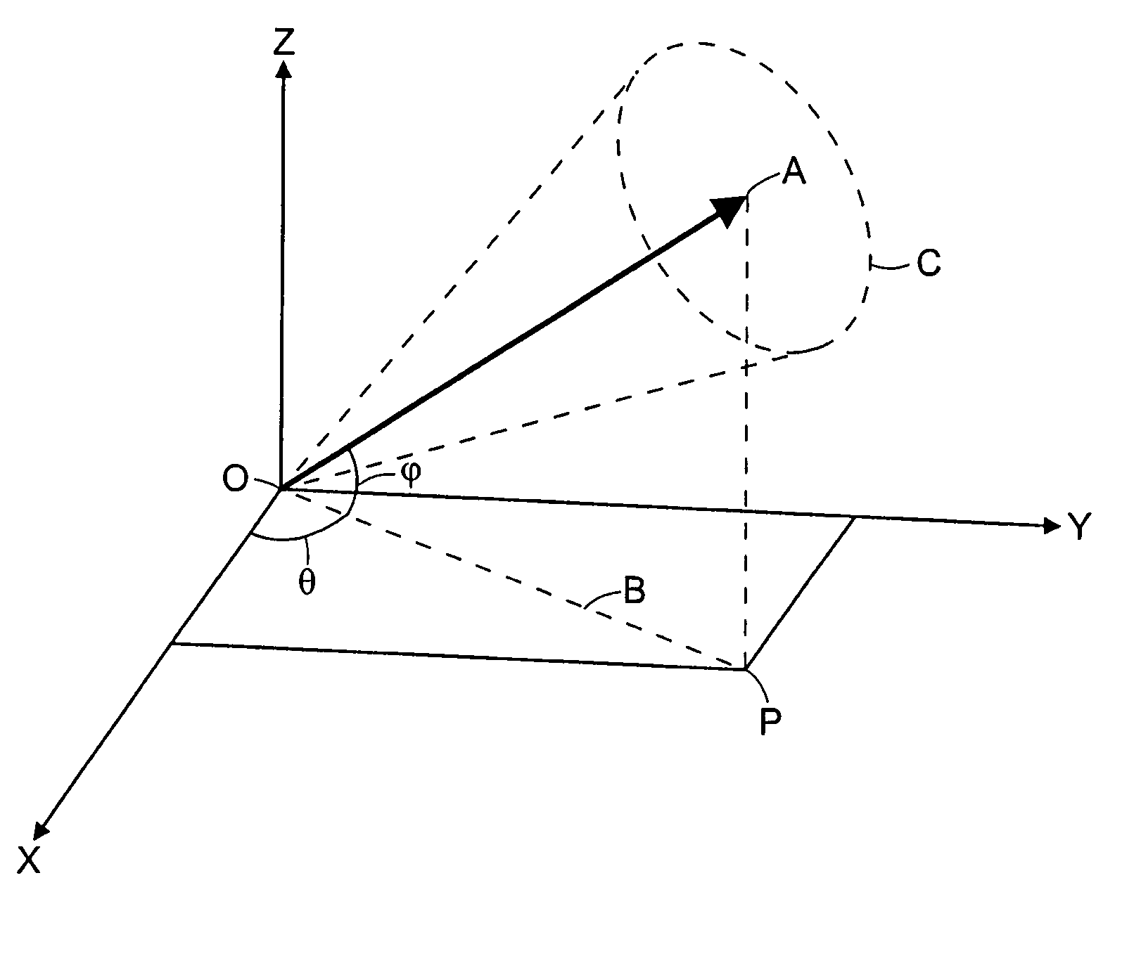
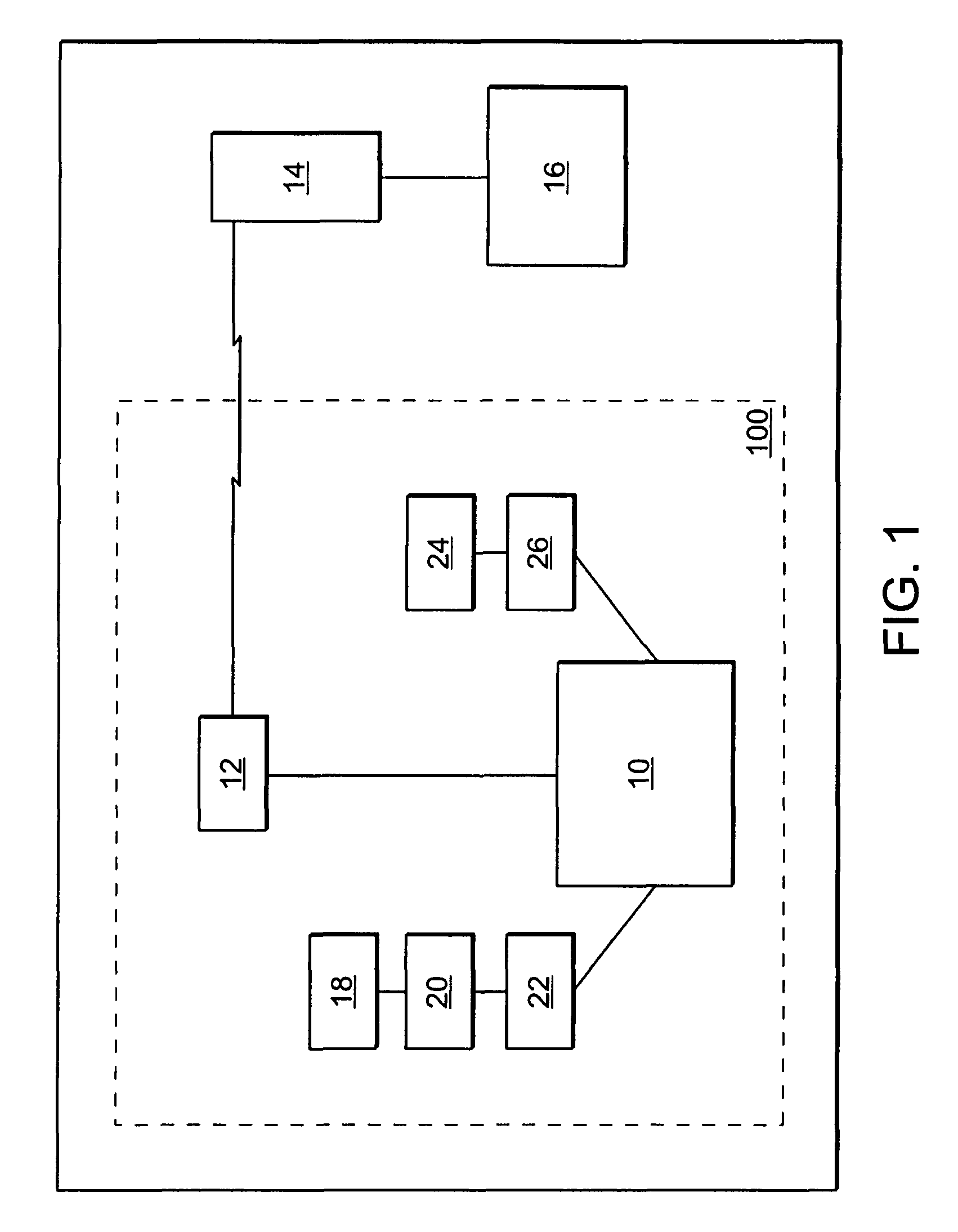
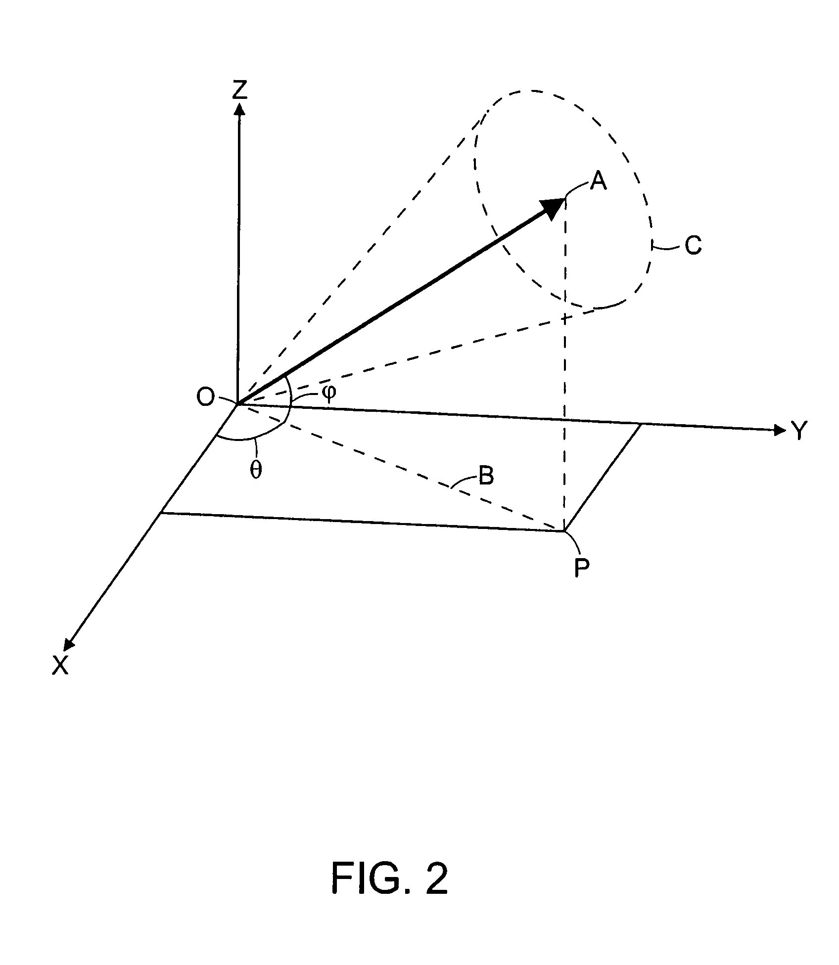
[0028]Referring now to the Figures, the present invention is described below in detail. Turning specifically to FIG. 1, a system 1 for providing geographic information is shown in schematic format. As described more fully below, the system 1 of the present invention is an improvement over existing geographic information systems. In particular, the system 1 provides a user with a more intuitive and egocentric model of his or her physical surroundings.

[0029]The system 1 generally includes a mobile device 100, designated by the phantom line that encompasses a number of elements, a wireless router 14 and a database 16. The mobile device 100 may be any portable electronic or computing device, such as a personal digital assistant, wireless telephone, laptop personal computer, tablet personal computer or any other electronic apparatus that is capable of carrying out digital instructions based on data that is supplied from a remote locatio...


PUM


Abstract

The present invention provides a system and mobile device for providing geographic information to a user. The system includes a mobile device that is wirelessly connected to a geographic database. The mobile device includes a plurality of sensors for determining a first location and a first direction. A controller is adapted to provide information requested based on local queries and distal queries. In addition, the controller can respond to thematic queries of each variety, wherein the database search is limited to objects, entities or features that fit within a selected theme. Finally, the controller is adapted to select and order query results based upon two- and three-dimensional query windows.

Description

RELATED APPLICATIONS[0001]The present application is a Non-Provisional of U.S. Provisional Application Ser. No. 60 / 523,581, filed on Nov. 20, 2003, the entire contents of which are incorporated by reference.[0002]1. Field of the Invention[0003]The present invention relates generally to systems and devices for determining geographic information, and specifically to distributed systems and devices for interpreting spatial and geographic data and presenting said data to a user.[0004]2. History of the Related Art[0005]Maps still provide the main means for understanding spatial environments, as well as for performing tasks such as wayfinding, trip-planning, and location-tracking. Static traditional maps have several disadvantages. First, maps necessarily have a fixed orientation. That is, the map always faces in one direction (typically north). The map users, however, may be facing any direction at any given moment. Hence, in order to understand the map users need to perform some kind of...

Claims


Application Information

Patent Timeline
Patent Type & Authority Patents(United States)
IPC IPC(8): H04W24/00G01S19/48G01S5/02H04Q7/20H04Q7/38
CPCG01C21/20G01S5/0252
Inventor FRANK, CHRISTOPHEREGENHOFER, MAX
Owner TAHOE RES LTD
Why Eureka
Try Eureka