Method and apparatus for establishing optimum route to intersection destination for navigation system

a navigation system and optimum route technology, applied in surveying, navigation, instruments, etc., can solve the problems of inappropriate route creation, navigation system failure to create optimum calculated route, etc., and achieve accurate and efficient results

Active Publication Date: 2013-10-15
ALPINE ELECTRONICS INC
View PDF3 Cites 6 Cited by
  • Summary
  • Abstract
  • Description
  • Claims
  • Application Information

AI Technical Summary

Benefits of technology

[0014]It is another object of the present invention to provide a method and apparatus for a navigation system which is capable of obtaining the most preferable route to the intersection destination by attaching a dummy link of zero-length to the intersection when calculating a route.
[0015]It is a further object of the present invention to provide a method and apparatus for a navigation system which is capable of obtaining the most preferable route to the intersection destination by attaching a dummy link of zero-length so as to calculate a route to the dummy link rather than to the original intersection.
[0019]In the method of the present invention, the step of connecting the end of the virtual zero-length dummy link to the intersection destination further includes a step of connecting the end of the virtual zero-length dummy link to all of the link-spot pairs that indicate the intersection destination. In the method of the present invention, the step of selecting the most preferable route to the temporary destination includes a step of selecting the preferable route that includes one of the link-spot pairs indicating the intersection destination of least cost.
[0023]According to the present invention, the navigation system creates and stores the virtual zero-length dummy link which will be added to the map data (intersection links) associated with a specified intersection when calculating a route to the intersection. Namely, the navigation system is capable of obtaining the most preferable route to the destination for a route guidance operation when the destination is an intersection. In the present invention, the navigation system obtains the most preferable route to the intersection destination by attaching the virtual zero-length dummy link to the intersection so as to calculate a route to the dummy link rather than to the original intersection. After attaching the virtual zero-length dummy link to the intersection destination, the navigation system examines a plurality of road segments (link-spot pairs) indicating the original intersection that lead to the dummy link for selecting the most preferable route. In other words, by temporally interpreting that the location of the end node of the dummy link as a final location of the intersection destination, the navigation system is able to produce the most accurate and efficient calculated route to the intersection destination.

Problems solved by technology

In calculating a route to such an intersection, however, in some cases, a navigation system of today may fail to create an optimum calculated route.
Such an inappropriate route may be created because of the structure of the map data currently available in the market in which an intersection is defined by a plurality of road segments (link-spot pairs) each being a one way road.

Method used


Image

  • Method and apparatus for establishing optimum route to intersection destination for navigation system
  • Method and apparatus for establishing optimum route to intersection destination for navigation system
  • Method and apparatus for establishing optimum route to intersection destination for navigation system

Examples


Embodiment Construction

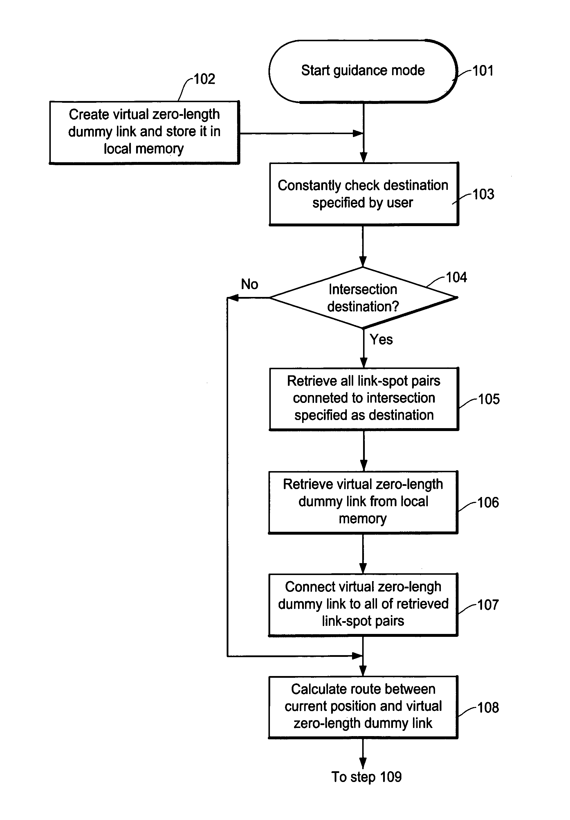
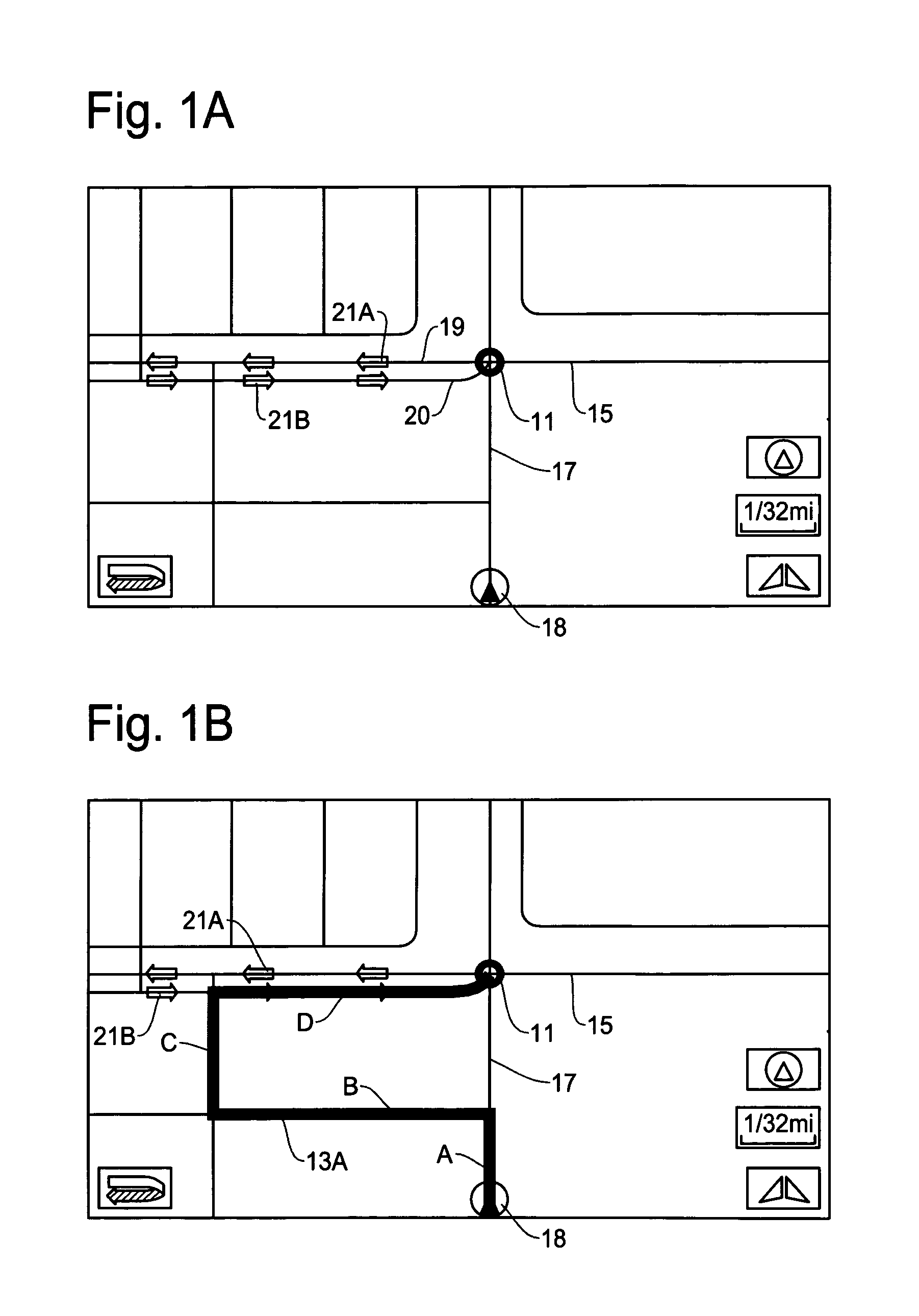
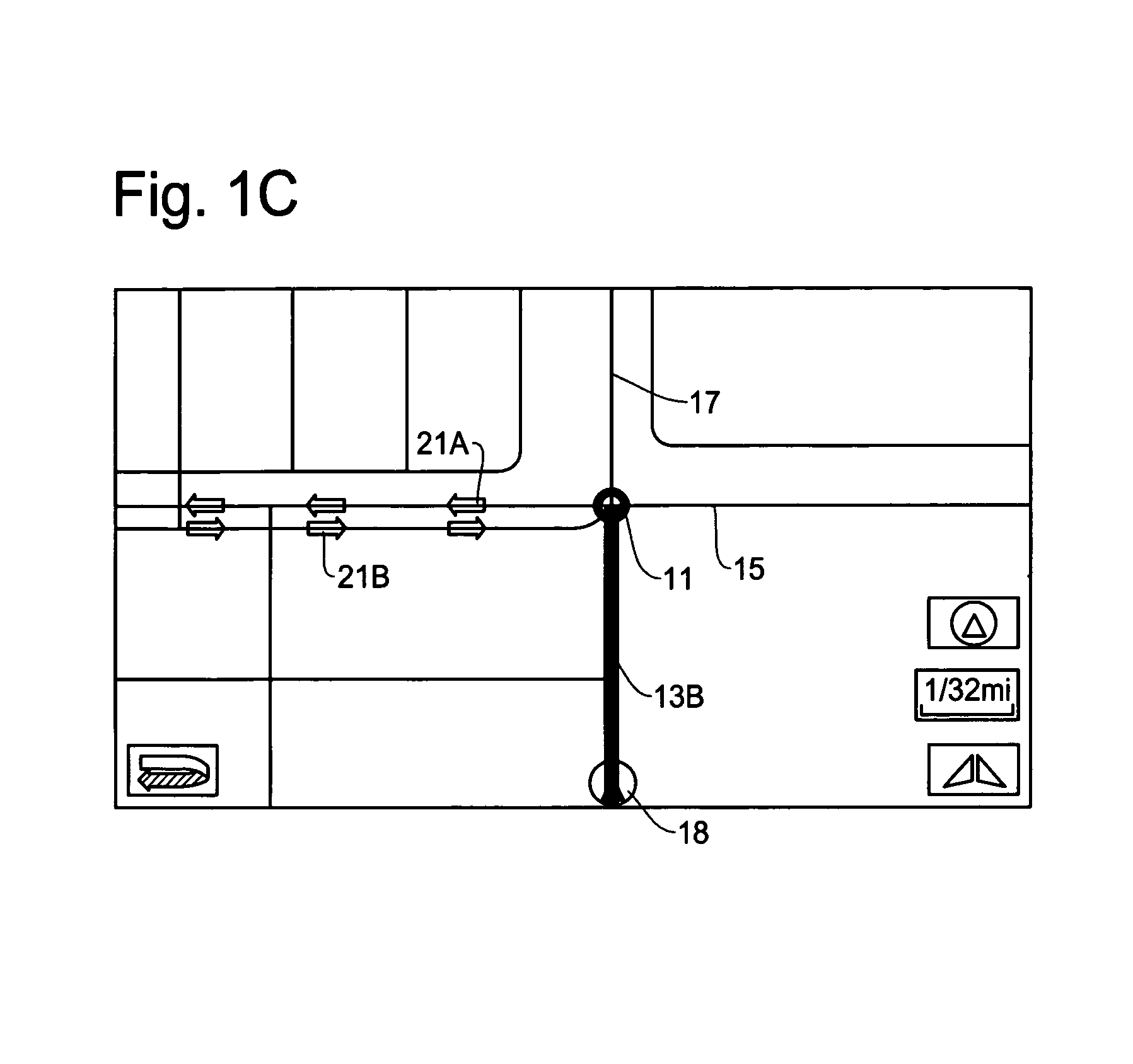
[0033]The method and apparatus of the present invention for creating an accurate and efficient calculated route to a destination when the destination is an intersection is described in detail with reference to the accompanying drawings. The present invention is designed to provide the process and structure for establishing a calculated route to the intersection destination by attaching a dummy link of zero-length to the intersection destination. By attaching the virtual zero-length dummy link to the map data indicating the intersection destination, the navigation system is able to find the best route to an end node of the dummy link while selecting the most appropriate road segment (intersection link of link-spot pair) indicating the intersection leading to the dummy link.

[0034]When the user selects a destination through an input method of “Intersection”, for example, by specifying two cross streets, the navigation system activates the route calculation method of the present inventi...


PUM


Abstract

A method and apparatus for a navigation system for calculating a route to an intersection destination establishes an optimum route to the intersection. The method and apparatus creates a virtual zero-length dummy link, connects one end of the virtual zero-length dummy link to all link-spot pairs indicating an original intersection destination, sets another end of the virtual zero-length dummy link as a temporary destination, calculates possible routes between the temporary destination and a current vehicle position and selects the optimum route. After determining the optimum route, the navigation system removes the virtual zero-length dummy link and starts the route guidance operation to the intersection destination.

Description

FIELD OF THE INVENTION[0001]This invention relates to a method and apparatus for a navigation system to determine a route to a destination, and more particularly, to a method and apparatus for a navigation system for establishing the most preferable calculated route to a destination when such a destination is an intersection by attaching a dummy link of zero-length to the intersection destination.BACKGROUND OF THE INVENTION[0002]A navigation system performs travel guidance for enabling a user to easily and quickly reach the selected destination. A typical example is a vehicle navigation system where a vehicle is equipped with a navigation function to guide a user to a destination through a calculated route. Such a navigation system detects the position of the user's vehicle, and reads out map data pertaining to an area at the current vehicle position from a data storage medium, for example, a CD-ROM (compact disc read-only memory), a DVD (digital versatile disc), or a hard disc, or ...

Claims


Application Information

Patent Timeline
Patent Type & Authority Patents(United States)
IPC IPC(8): G01C21/00G08G1/123G01C21/34
CPCG01C21/3446
Inventor VU, TIENZHAO, LEI
Owner ALPINE ELECTRONICS INC
Why Eureka
Try Eureka