Method, tool, and device for determining the coordinates of points on a surface by means of an accelerometer and a camera

a technology of accelerometer and surface, applied in the field of spatial coordinate measurement, can solve problems such as insufficient high-precision measurements using a techniqu

Active Publication Date: 2015-05-26
SENSOPIA
View PDF32 Cites 38 Cited by
  • Summary
  • Abstract
  • Description
  • Claims
  • Application Information

AI Technical Summary

Problems solved by technology

The high speed of light makes this technique inadequate for high precision measurements, where triangulation is preferred.

Method used


Image

  • Method, tool, and device for determining the coordinates of points on a surface by means of an accelerometer and a camera
  • Method, tool, and device for determining the coordinates of points on a surface by means of an accelerometer and a camera
  • Method, tool, and device for determining the coordinates of points on a surface by means of an accelerometer and a camera

Examples


Embodiment Construction

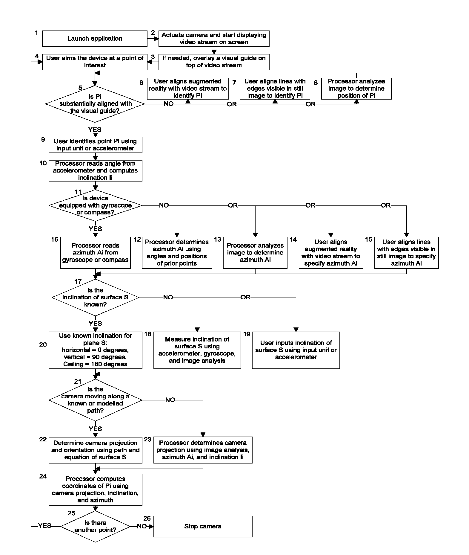
[0021]Reference is now made to FIG. 1, wherein there is shown an example of a simplified flow diagram describing the various steps of the method. It is understood that the steps can be performed in any order as long as identifying point Pi 4-9, reading the accelerometer 10, determining the azimuth 11-16, determining the angle between surface S and a horizontal plane 17-20, and determining the projection of the camera onto surface S 21-23 are all performed before computing the point coordinates 25.

[0022]According to one of the preferred embodiments of the invention, the user first launches an application 1 and actuates the camera 2 before aiming at the first point of interest. The user stops the camera 26 once the position of the last point has been specified.

[0023]According to one of the preferred embodiments of the invention, the user specifies the position of point Pi by aligning an augmented reality drawing 3 with a continuous video stream coming from the camera 6. The augmented ...


PUM


Abstract

A method, tool, and device for determining the coordinates or a plurality of points on a substantially plane surface by means of an accelerometer and a camera. The coordinates of each point are computed by determining a perpendicular projection of the camera onto the surface, identifying each point, measuring an inclination (the angle between the line of sight of the camera and gravity) using the accelerometer, and determining an azimuth (the angle of the line of sight of the camera around gravity).

Description

BACKGROUND OF THE INVENTION[0001]Terminology in this description is defined as follows:[0002]Azimuth: The angle of the line of sight of the camera around gravity.[0003]Inclination: The angle between the line of sight of the camera and gravity.[0004]Augmented reality: Live view of a physical, real-world environment whose elements are augmented by computer-generated sensory input. Artificial information about the environment and its objects can be overlaid on the real world.[0005]Substantially plane: Said of a surface on which a line joining any two points is never more than 10% of its length apart from the surface. Users with greater precision requirements may require a lower percentage of deviation, while users having lower precision requirements may allow more deviation.FIELD OF THE INVENTION[0006]The present invention relates in general to the measurement of spatial coordinates using a device.DESCRIPTION OF THE PRIOR ART[0007]Over the last centuries, man has invented many techniqu...

Claims


Application Information

Patent Timeline
Patent Type & Authority Patents(United States)
IPC IPC(8): H04N7/18G01C11/02
CPCG01C11/02
Inventor MALKA, FRANCIS RUBENDESFORGES, GILLES JEAN
Owner SENSOPIA
Why Eureka
Try Eureka