Broad area geospatial object detection using autogenerated deep learning models

a deep learning model and geospatial object technology, applied in image analysis, image enhancement, instruments, etc., can solve the problems of limited range of image analysis applications, limited use of image analysis (particularly image analysis of remotely-sensed images), and high cost, and achieve the effect of reducing the cost of image analysis

Active Publication Date: 2017-03-07
MAXAR INTELLIGENCE INC
View PDF7 Cites 33 Cited by
  • Summary
  • Abstract
  • Description
  • Claims
  • Application Information

AI Technical Summary

Problems solved by technology

However, the extent of the use of image analysis (particularly image analysis of remotely-sensed images), particularly for identifying or locating targets of interest, has always been limited by the need for highly-trained, specialized image analysts or interpreters.
The need for specialized (and expensive) skills has limited the use of image analysis to a correspondingly limited range of applications (notably military, homeland defense, and law enforcement).
The market for image analysis has also historically been limited by the high cost of obtaining images to analyze.
But even this market has been limited from achieving its full potential because of the still-present requirement for expensive, scarce image analysis talent.
However, these efforts have required the work of image analysts, limiting what could be done.
Unfortunately, until recently, this pursuit has met with little success except when both the object of interest and the background against which it is presented have been tightly controlled.
The technological barriers have been present because, like its biological counterpart, computer visual processing requires computational power and amounts of memory storage that have been prohibitive up until the last 15 years.
All of these early attempts gave results that were extremely sensitive to such variables as lighting, exact object placement in the field of sample, and exact object orientation, sometimes to the degree that the object of interest was not identifiable in the original image without great care.
These include, for example, the Caffe library (Berkeley Vision and Learning Center), the Torch7 library (Nagadomi) and the cuda-covnet2 library (Alex Krizhevsky) While the convolutional neural network-deep learning model method has been widely and very successfully applied to ground based photography and video, it has not found application in the field of geospatial image analysis.

Method used


Image

  • Broad area geospatial object detection using autogenerated deep learning models
  • Broad area geospatial object detection using autogenerated deep learning models
  • Broad area geospatial object detection using autogenerated deep learning models

Examples


Embodiment Construction

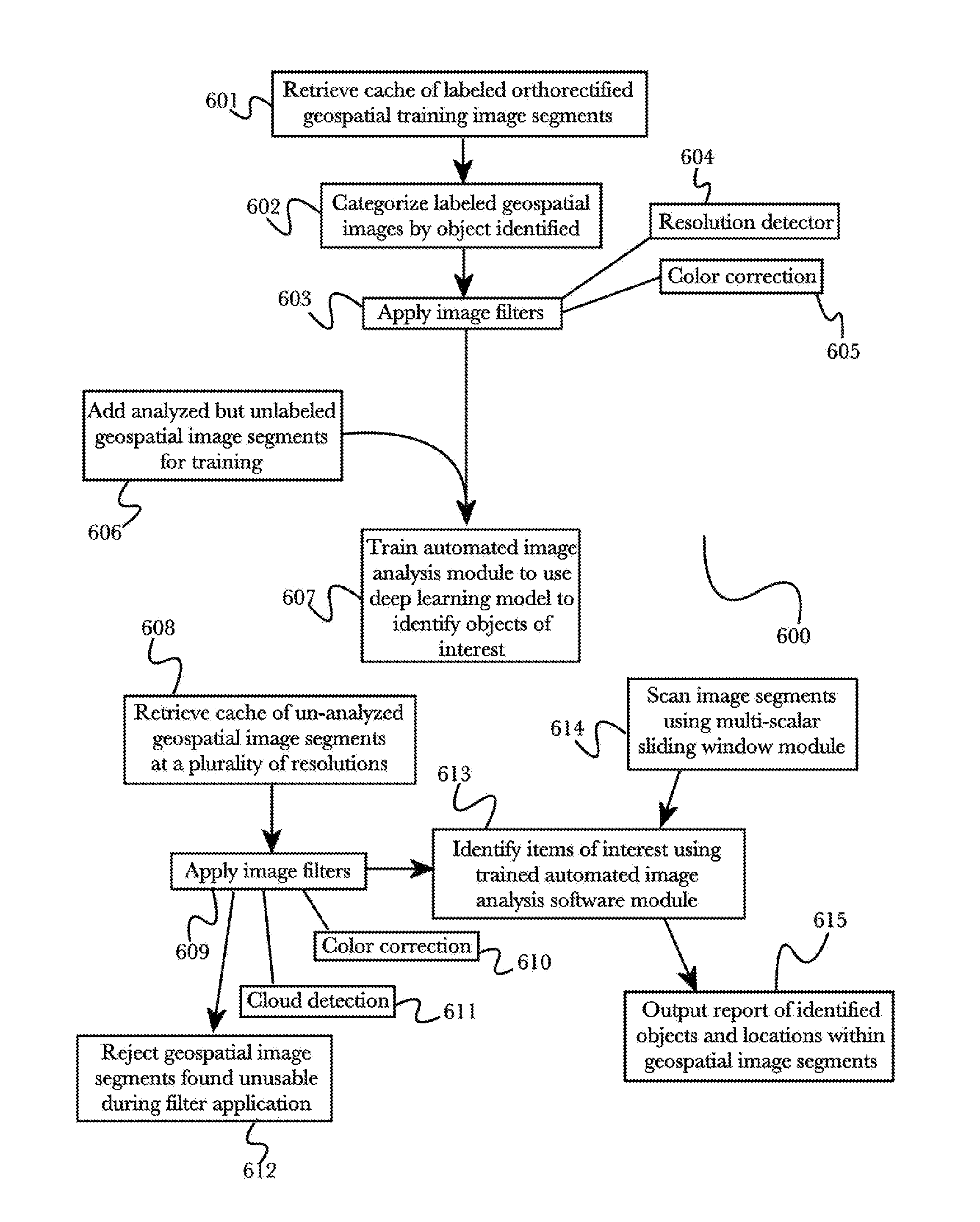
[0022]The inventor has conceived, and reduced to practice, various systems and methods for advanced broad area geospatial object detection using autogenerated deep learning models.

[0023]One or more different inventions may be described in the present application. Further, for one or more of the inventions described herein, numerous alternative embodiments may be described; it should be understood that these are presented for illustrative purposes only. The described embodiments are not intended to be limiting in any sense. One or more of the inventions may be widely applicable to numerous embodiments, as is readily apparent from the disclosure. In general, embodiments are described in sufficient detail to enable those skilled in the art to practice one or more of the inventions, and it is to be understood that other embodiments may be utilized and that structural, logical, software, electrical and other changes may be made without departing from the scope of the particular invention...


PUM


Abstract

A system for automated geospatial image analysis comprising a deep learning model module and a convolutional neural network serving as an automated image analysis software module. The deep learning module receives a plurality of orthorectified geospatial images, pre-labeled to demarcate objects of interest, and optimized for the purpose of training the neural network of the image analysis software module. The module presents marked geospatial images and a second set of unmarked, optimized, training geospatial images to the convolutional neural network. This process may be repeated so that an image analysis software module can detect multiple object types or categories. The image analysis software module receives a plurality of orthorectified geospatial images from one or more geospatial image caches. Using multi-scale sliding window submodule, image analysis modules scan geospatial images, detect objects present and locate them on the geographical latitude-longitude system. The system reports the results in the requestor's preferred format.

Description

BACKGROUND OF THE INVENTION[0001]Field of the Invention[0002]The present invention is in the field of image analysis, and more particularly in the field of the use of deep learning model computer vision systems for automated object identification from geospatial imagery.[0003]Discussion of the State of the Art[0004]Image analysis has been an important field of technology at least since the period of World War 2, when extensive use of image analysis, photogrammetry, and related technologies were used in conjunction with aerial photography for intelligence and bombing damage assessment purposes (among others). However, the extent of the use of image analysis (particularly image analysis of remotely-sensed images), particularly for identifying or locating targets of interest, has always been limited by the need for highly-trained, specialized image analysts or interpreters. The need for specialized (and expensive) skills has limited the use of image analysis to a correspondingly limite...

Claims


Application Information

Patent Timeline
Patent Type & Authority Patents(United States)
IPC IPC(8): G06K9/62G06K9/00G06T5/00G06T7/00G06V10/764G06V20/13
CPCG06K9/6259G06K9/00671G06T5/00G06T7/33G06T7/344G06T2207/10032G06T2207/20081G06T2207/20084G06T2207/20112G06T2207/30181G06T2207/30184G06T2207/30212G06T2207/30252G06T7/74G06V20/13G06V10/454G06V10/82G06V10/764G06F18/24137G06T5/005
Inventor ESTRADA, ADAMJENKINS, ANDREWBROCK, BENJAMINMANGOLD, CHRIS
Owner MAXAR INTELLIGENCE INC
Why Eureka
Try Eureka