Eureka AIR delivers breakthrough ideas for toughest innovation challenges, trusted by R&D personnel around the world.

SDINS/GPS combined guidance system time synchronism and synchronous data extraction method

An integrated navigation system and GPS data technology, applied in the field of SDINS and GPS integrated navigation systems, can solve problems such as limiting synchronization accuracy, and achieve the effects of task reduction, high synchronization accuracy, and good real-time performance.

Inactive Publication Date: 2009-06-10
BEIHANG UNIV
View PDF5 Cites 4 Cited by
  • Summary
  • Abstract
  • Description
  • Claims
  • Application Information

AI Technical Summary

Problems solved by technology

Both methods use 1PPS to request an interrupt from the CPU. Since the CPU itself has a certain delay in responding to external interrupts, the synchronization accuracy is limited.

Method used


Image

  • SDINS/GPS combined guidance system time synchronism and synchronous data extraction method
  • SDINS/GPS combined guidance system time synchronism and synchronous data extraction method
  • SDINS/GPS combined guidance system time synchronism and synchronous data extraction method

Examples


Embodiment Construction

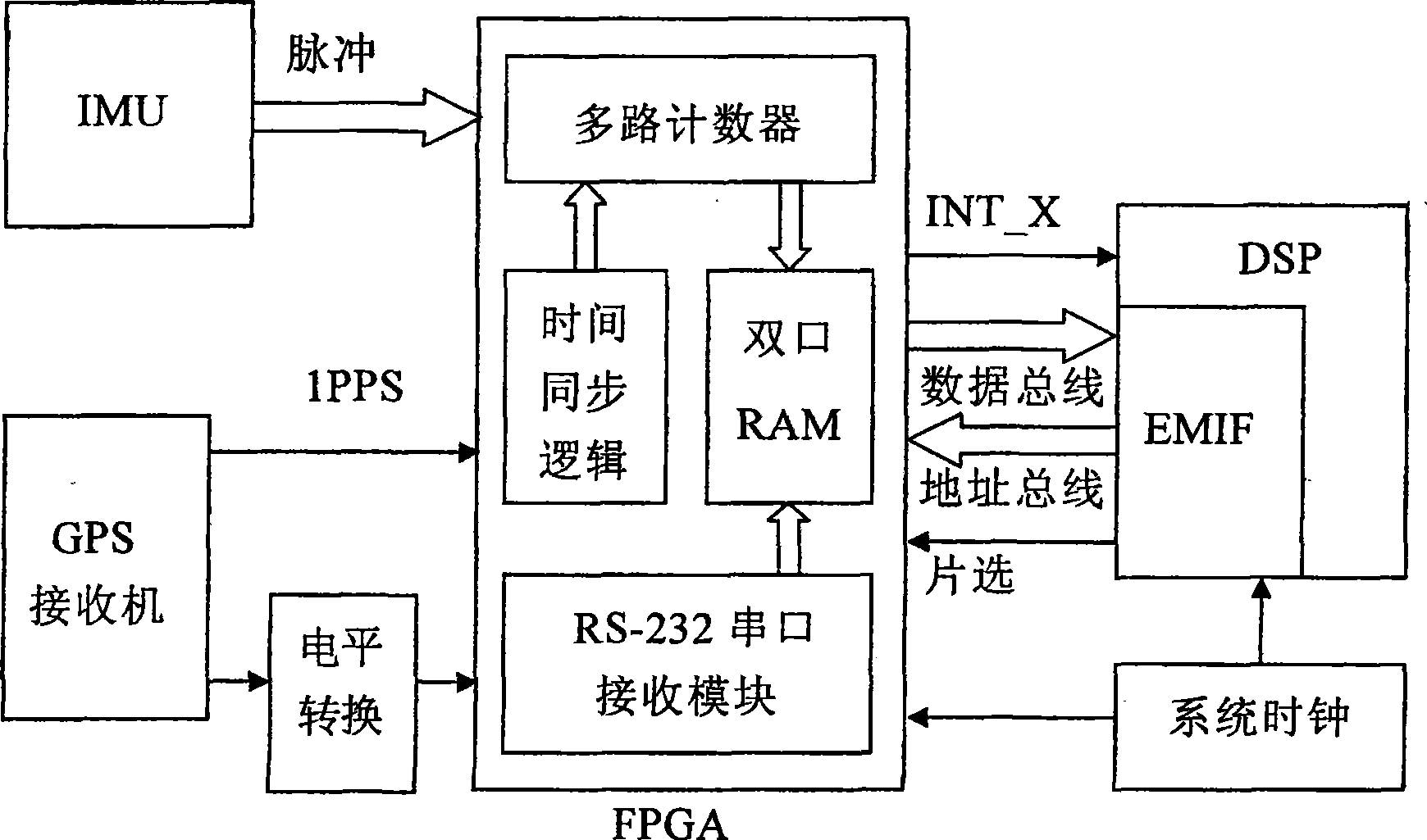
[0030] The invention adopts FPGA to realize time synchronization circuit, adopts DSP to extract synchronous data, and DSP communicates with dual-port RAM in FPGA through EMIF in interrupt mode, and reads IMU data and GPS data. FPGA selects the products of American XiIinx Company; DSP selects TMS320C6713B floating-point series products of TI Company. The hardware structure of the present invention is as figure 1 Shown:

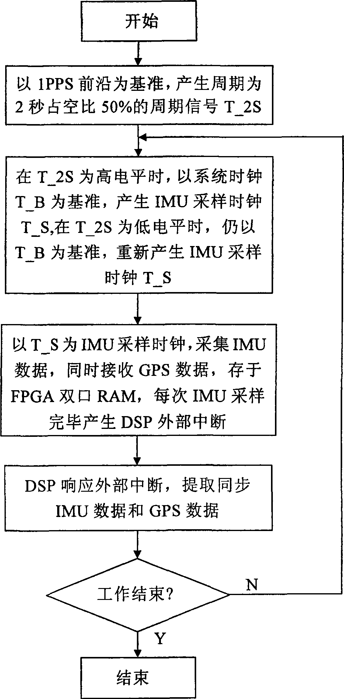
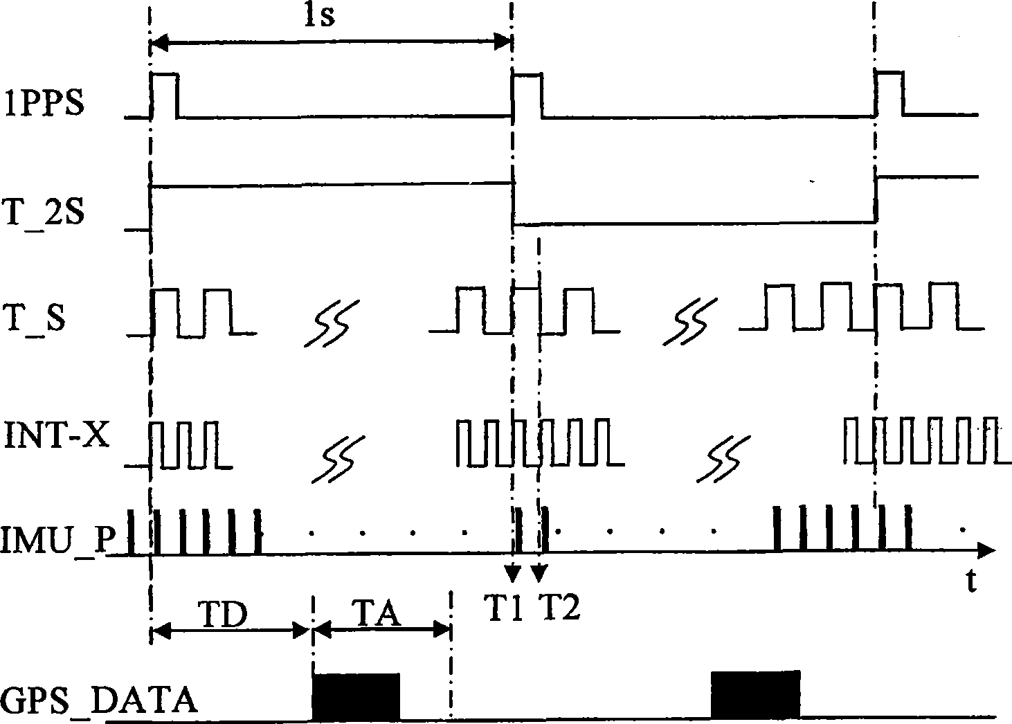
[0031] The hardware circuit used to implement the method of the present invention is composed of FPGA, floating-point DSP, RS-232 level conversion and system clock. Taking the 1PPS of the GPS receiver as a reference, the IMU data sampling clock is generated through the time synchronization logic in the FPGA, and the pulse signals of the IMU are counted by the multi-channel counter to realize the synchronization of the IMU data sampling and 1PPS, thereby realizing the IMU data and GPS data synchronization. Each time the IMU data is sampled, the counting resul...


PUM


Abstract

The invention relates to a SDINS / GPS integrated navigation system time synchronization method and synchronous data acquisition method. 1 PPS pulse of a GPS receiver is used as a reference to generate an IMU sampling clock, and the pulse signal outputted from the IMU is counted by a counter in the FPGA, so that IMP data sampling is synchronous with 1 PPS, and the synchronization of IMU data and GPS data is realized. GPS data is received through a serial port for realizing VHDL language. The floating point DSP responds the external interruption of the FPGA, reads the IMU data inside the FPGA, and acquires synchronous IMU data and reads GPS data in accordance with the IMU synchronization marks and GPS reading marks. The invention adopts hardware synchronization and time synchronization, leading to good stability. It can realize re-synchronization with 1 PPS, so as to provide high-precision synchronous data for integrated navigation computation and improve the overall performance of integrated navigation system. The DSP acquires synchronous data with interrupt mode and hardly occupies the DSP resource for computation, leading to good real-time performance.

Description

technical field [0001] The invention relates to a SDINS (Strapdown Inertial Navigation System Strapdown INS) / GPS combined navigation system time synchronization and synchronous data extraction method, which belongs to the technical field of combined navigation and is suitable for SDINS and GPS composed of inertial measurement units output in pulse mode Integrated navigation system with high synchronization accuracy and good real-time performance. Background technique [0002] SDINS / GPS integrated navigation system adopts data fusion method for information fusion to improve the overall navigation accuracy of the system. When performing information fusion, it is necessary to ensure that the navigation information from SDINS and GPS are data at the same time, that is, the data synchronization problem of the two subsystems must be solved first. The two subsystems of SDINS and GPS use independent time systems: the IMU in SDINS has its own frequency standard. In actual use, due t...

Claims


Application Information

Patent Timeline
Patent Type & Authority Patents(China)
IPC IPC(8): G01C21/26G01C21/28G01C21/16G01S5/14H03L7/00G01S19/49
Inventor 房建成李金涛徐帆
Owner BEIHANG UNIV
Why Eureka
Eureka Blog
Learn More