Pilotless plane landing navigation method and its device

A technology of unmanned helicopters and guidance devices, which is applied in the fields of image recognition and navigation communication, can solve the problems that limit unmanned helicopters to land lightly and flexibly, and achieve the effects of reducing computational complexity, low price, and improving operability

Inactive Publication Date: 2007-07-18
BEIHANG UNIV
View PDF0 Cites 36 Cited by
  • Summary
  • Abstract
  • Description
  • Claims
  • Application Information

AI Technical Summary

Problems solved by technology

[0007] In addition, in the past, the "H" type or specially designed marks used in helicopter landing sites were usually used as landing beacons for guiding unmanned heli...

Method used


Image

  • Pilotless plane landing navigation method and its device
  • Pilotless plane landing navigation method and its device
  • Pilotless plane landing navigation method and its device

Examples


Embodiment Construction

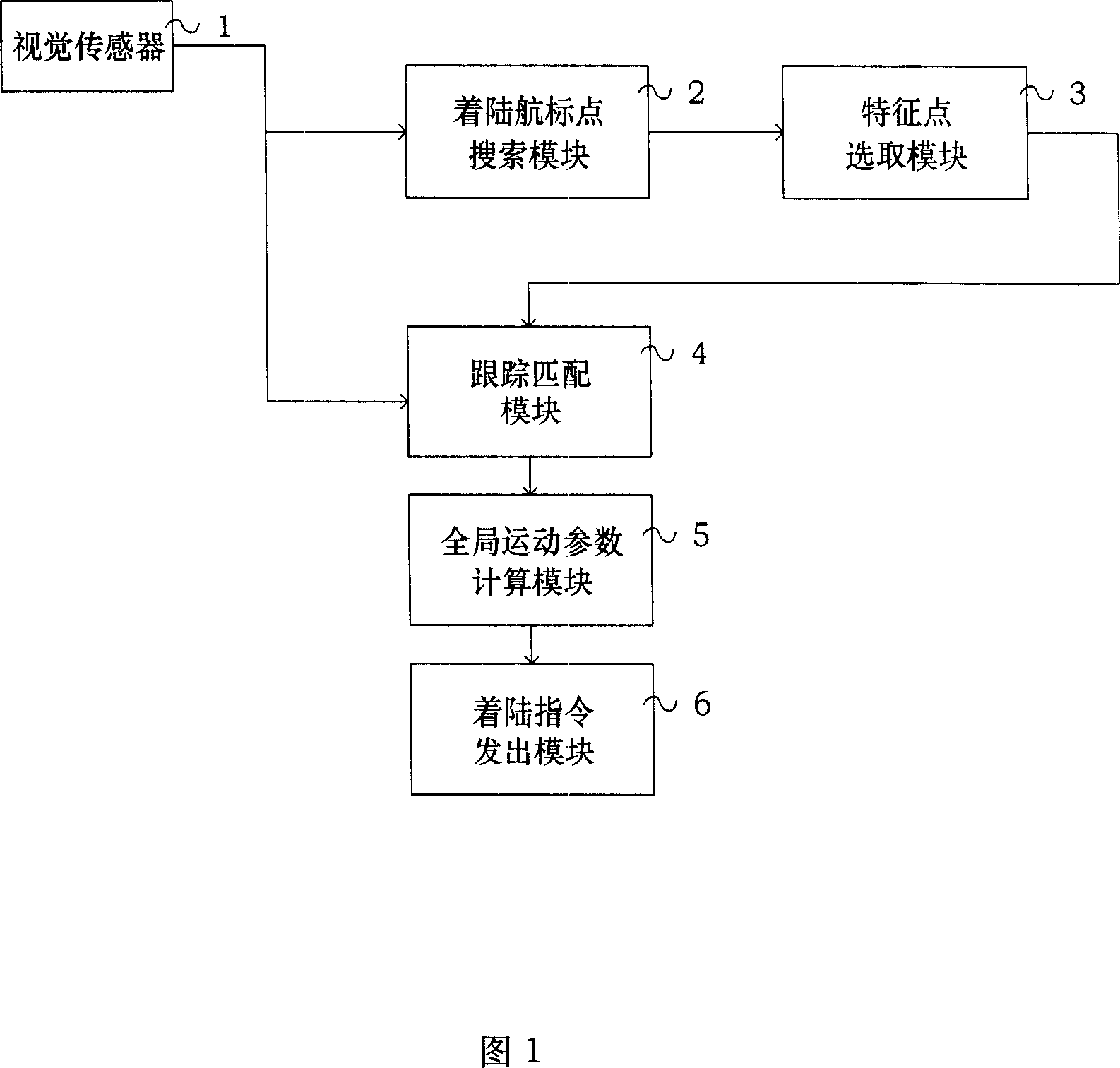
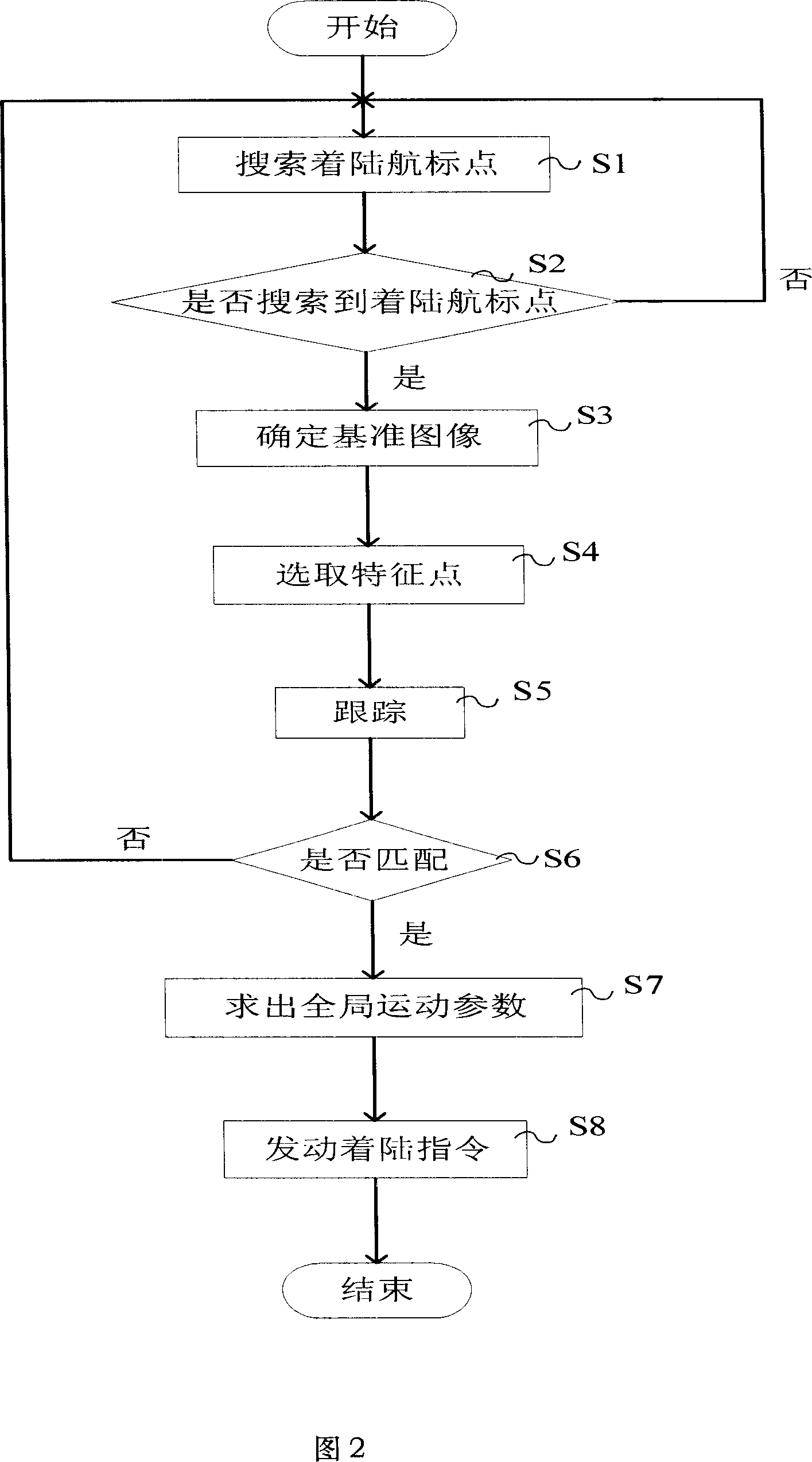
[0026] FIG. 1 is an example of a functional block diagram of an unmanned helicopter landing guidance device according to the present invention.

[0027] As shown in Figure 1, the basic structure of the unmanned helicopter landing guidance device includes: visual sensor 1, landing beacon point search module 2, feature point selection module 3, tracking matching module 4, global motion parameter calculation module 5 and landing command issuing module 6.

[0028] The visual sensor 1 is configured on the unmanned helicopter to obtain ground image information in real time. The landing beacon point module 2 processes the image acquired by the visual sensor 1 to search for the landing beacon point area. If the beacon point is found, it is determined by The feature point selection module 3 selects the feature points, and then the tracking module 4 performs the tracking and matching of the feature points. The global motion parameter calculation module 5 calculates the motion parameters...


PUM


Abstract

The invention relates to pilotless helicopter landing guiding method and its implement device. The method includes the following steps: using vision transducer to collect image signal; searching the small area of the landing navigation mark; searching its characteristic point to follow and match; if the matching is successful, finding out no man helicopter whole moving parameter; emitting landing order. The advantages of the invention are that it has high precision, can ensure landing guiding mission success rate and real time, greatly reduce cost, and full play to no man helicopter legerity and agility.

Description

technical field [0001] The invention belongs to the technical field of image recognition and navigation communication, and in particular relates to an unmanned helicopter landing guidance method and a device for implementing the method. Background technique [0002] When an unmanned helicopter performs autonomous landing, it must accurately grasp the positioning information of the landing point, and at the same time must obtain accurate altitude, speed, heading and other self-motion information, and provide the above information to the autonomous landing system. In the past, as a common method to guide unmanned helicopters to land autonomously at a fixed point, the positioning information of the above-mentioned landing points and the self-motion information of the unmanned helicopters are obtained by means of methods such as inertial measurement units, GPS, and radio altimeters. [0003] However, in the previous methods, there is a shortcoming of poor real-time performance. ...

Claims


Application Information

Patent Timeline
IPC IPC(8): G01C21/00G01C21/24G01C21/20G01C21/10G01C21/12G01C11/00G06K9/46
Inventor 张晓林聂振钢谭征陆国雷李宏伟
Owner BEIHANG UNIV
Why Eureka
Try Eureka