Three-dimensional stratum characteristic decryption method based on geologic information acquisition data

A technology of information acquisition and three-dimensional formation, applied in seismic signal processing, seismology for logging records, etc., can solve problems such as inseparability, inability to truly reflect attribute characteristics, and disregard of intra-area contradictions or other attributes, etc. To achieve the effect of improving the accuracy of interpretation

Inactive Publication Date: 2008-07-16
CNPC BOHAI DRILLING ENG
View PDF0 Cites 21 Cited by
  • Summary
  • Abstract
  • Description
  • Claims
  • Application Information

AI Technical Summary

Problems solved by technology

[0003] The purpose of the present invention is to overcome that the two-dimensional plane intersection method deletes or does not consider contradictions or other attributes in the area, especially not applicable to complex working conditions and complex geological conditions, may give wrong conclusions, and the divided same attribute area contains For othe

Method used


Image

  • Three-dimensional stratum characteristic decryption method based on geologic information acquisition data
  • Three-dimensional stratum characteristic decryption method based on geologic information acquisition data
  • Three-dimensional stratum characteristic decryption method based on geologic information acquisition data

Examples


Embodiment 1

[0083] Example 1: Application of a three-dimensional stratigraphic feature interpretation method based on gas logging geological information collection data in the Chenghai-Minghua Town (Guantao, Shahe Street) work area.

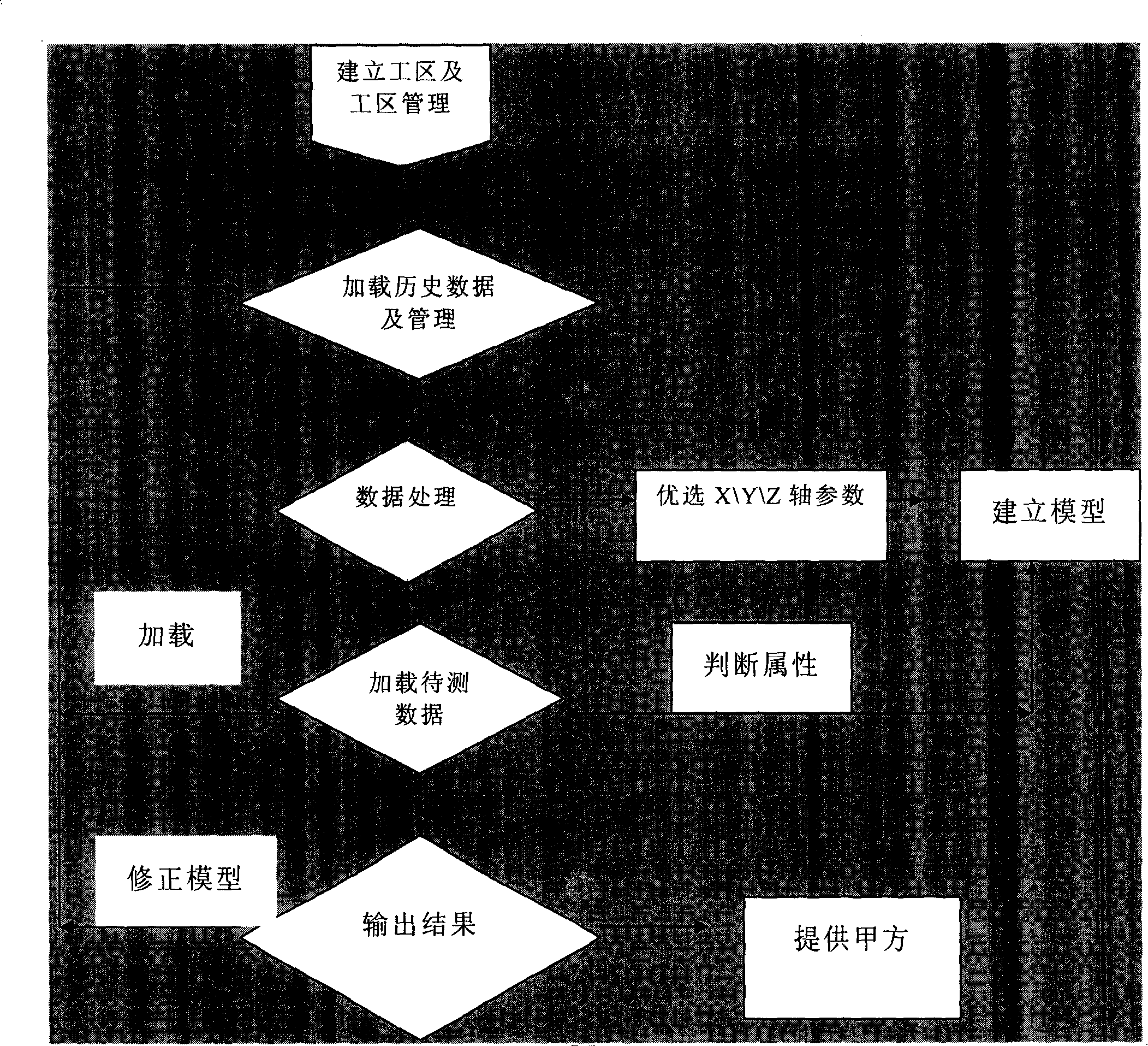
[0084] Step A: Establish the work area and work area management, and establish the work area Chenghai-Minghua Town (Guantao, Shahe Street).

[0085] Step B: Load historical data and manage, and import historical data—gas logging data in Chenghai area and oil testing conclusions (Table 1) into the database.

[0086] Table 1. Gas logging data and oil testing conclusions in the Chenghai area

[0087]

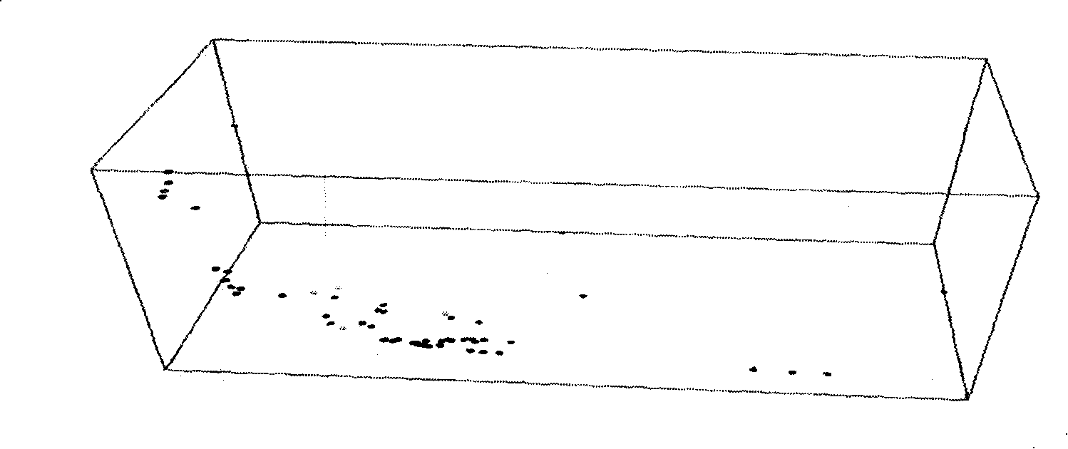
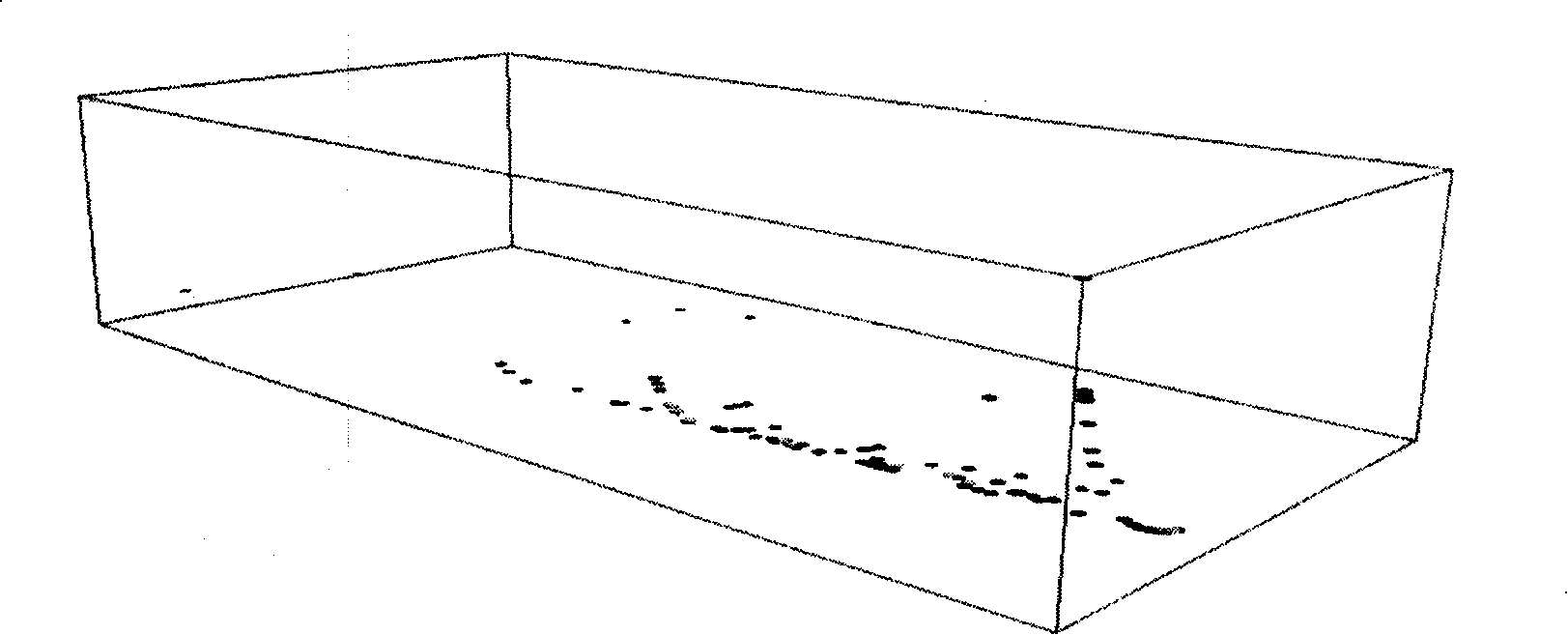
[0088] Step C: Data processing. The optimal parameters are used as the variables of the X, Y, and Z axes respectively, the X axis selects the parameter C1 / C2, the Y axis selects the parameter C2 / (C2+C3), and the Z axis selects (C2+C3+nC 4 +C 5 ) / (C 1 +C 2 +C 3 +iC 4 +nC 4 +C 5 )×100.

[0089] Step D: stratum attribute evaluation, importing the historic...

Embodiment 2

[0097] Example 2: The application of the three-dimensional stratigraphic feature interpretation method based on engineering logging geological information collection data in the Chenghai-Minghua Town (Guantao, Shahe Street) work area.

[0098] Step A: Establish the work area and work area management, and establish the work area Chenghai-Minghua Town (Guantao, Shahe Street).

[0099] Step B: Load historical data and manage, and import historical data—engineering mud logging data in Chenghai area and oil testing conclusions (Table 3) into the database.

[0100] Table 3 Engineering mud logging data and oil testing conclusions in the Chenghai area

[0101] Well depth

test oil

Inlet density

export density

Inlet temperature

output temperature

Inlet conductance

Export conductance

2291

oil layer

1.15

1.16

34.58

35.58

6.98

8.23

2292

oil layer ...

Embodiment 3

[0150] Example 3: Application of a three-dimensional stratigraphic feature interpretation method based on quantitative fluorescence logging geological information acquisition data in the Chenghai-Minghua Town (Guantao, Shahe Street) work area.

[0151] Step A: Establish the work area and work area management, and establish the work area Chenghai-Minghua Town (Guantao, Shahe Street).

[0152] Step B: Load historical data and manage. Import historical data—quantitative fluorescence logging data and oil testing conclusions (Table 5) in the Chenghai area into the database.

[0153] Table 5 Quantitative fluorescence logging data and oil testing conclusions in the Chenghai area

[0154] Well depth

oil test result

Ex(nm)

Em(nm)

F

u

C (mg / l)

N

n

3991.00

oil layer

336

374

179.00

10

96.20

8.3

2.6

3992.00

oil layer

330

379

281.00

5 ...


PUM


Abstract

A three dimension strata feature interpretation method based on geological information acquired data relates to the interpretation of three-dimensional hydrocarbon reservoir in petroleum exploration and development. To overcome the defect that the existing two-dimensional plane intersection method can not reflect the layer attribute feature faithfully, the invention comprises the following steps: A. establishing a work area, B. loading history data and management, C. processing data and selecting parameters as the variables of X-axis, Y-axis and Z-axis respectively, D. evaluating layer attribute, E. displaying a three-dimension chart, F. loading the data to be detected and judging layer attribute of the data to be detected, G. interpreting output results. The geological information data related to the variables of X-axis, Y-axis and Z-axis is at least one of gas logging data, engineering logging data, geochemical logging data, quantitative fluorescence logging data, nuclear magnetic logging data and logging data, and also can be the combinatorial operation and adjustable coefficient of the above parts. The invention has the advantages of raising the interpretation accuracy in complex condition, faithfully showing the layer attribute feature in working area and providing foundation for exploration and development decision.

Description

technical field [0001] The invention relates to an interpretation method for evaluating formation characteristics by applying geological data in oil and gas exploration and development, in particular to a three-dimensional formation characteristic interpretation method based on geological information collection data. Background technique [0002] The two important links in the process of petroleum geological exploration are the collection, processing and interpretation of formation geological information. The attribute characteristics of formations can be understood by interpreting the collected geological information. For example, gas logging is a geochemical logging method that directly discovers and evaluates oil and gas layers through the analysis of the oil and natural gas content and components in the drilling fluid. At present, commonly used interpretation methods for gas logging include triangular chart method, Pixler method, hydrocarbon composition slope diagram met...

Claims


Application Information

Patent Timeline
IPC IPC(8): G01V1/40G01V1/28G01V1/30G01V1/36
Inventor 邓建华姬月凤孙凤兰周丽华张洪秀
Owner CNPC BOHAI DRILLING ENG
Why Eureka
Try Eureka