A method for accurately verifying and protecting agricultural insurance based on remote sensing data and digital field

A technology of remote sensing data and field plots, applied in the field of agricultural insurance, can solve problems such as increasing national financial expenditure, difficulty in determining damage, and inability to accurately determine damage, and achieve the effects of avoiding moral hazard, saving manpower and material resources, and improving interpretation accuracy

Active Publication Date: 2019-01-18
安徽阡陌网络科技有限公司
View PDF9 Cites 8 Cited by
  • Summary
  • Abstract
  • Description
  • Claims
  • Application Information

AI Technical Summary

Problems solved by technology

[0007] The present invention provides an accurate inspection method for agricultural insurance based on remote sensing data and digital field data, which is used to solve the problem proposed in the background technology above. Technical Issues in Increasing State Fiscal Expenditure

Method used


Image

  • A method for accurately verifying and protecting agricultural insurance based on remote sensing data and digital field

Examples


Embodiment

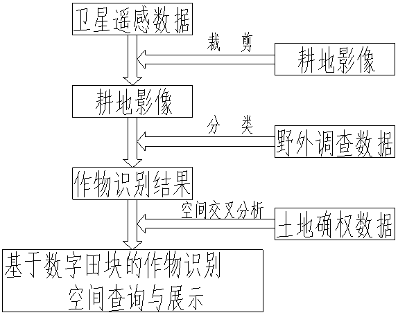
[0025] A method for accurate verification of agricultural insurance based on remote sensing data and digital fields, comprising the following steps:

[0026] S01: Field investigation, after farmers have purchased insurance and crops have been planted for a period of time, select samples randomly distributed in the research area according to the needs, send field investigators to the sample points to conduct investigations, record the GPS coordinates of the sample points, sample point information, and Take pictures, and, while holding the GPS locator, record the latitude and longitude and the type of features, so that it can be loaded into the image data later;

[0027] S02: Image interpretation, select the most suitable remote sensing image data from the image database, first use the digital field data field vector boundary to crop the remote sensing image, obtain effective cultivated land image data, and reduce the interference of other ground objects. The surveyed GPS data (...


PUM


Abstract

The invention provides a method for accurately verifying and protecting agricultural insurance based on remote sensing data and digital field, crop species and crop areas are identified using high-resolution remote sensing image data (remote sensing satellite data or aerial photographs of unmanned aerial vehicles) and ground survey results, by Combining digital field data, the farmer scale and field scale are accurately located, so as to realize the online inquiry of crop species and area and agricultural insurance online protection function according to the field information and the ascertained right holder information. The on-line verifying and protection method for agricultural insurance based on the agricultural remote sensing technology can realize the on-line verifying and protectionof the farmer household and the farmland only by a small amount of field sampling investigation, which not only improves the work efficiency, but also saves a large amount of manpower and material resources in the verifying and protection work of the agricultural insurance.

Description

technical field [0001] The present invention mainly relates to the technical field of agricultural insurance, in particular to an accurate verification method for agricultural insurance based on remote sensing data and digital fields. Background technique [0002] In the process of agricultural insurance inspection and insurance, since the contract data collection is based on multi-level aggregation from individuals to villages and towns, there is a phenomenon that does not match the real situation. The insurance company needs to spend a lot of manpower on the insurance results within the specified time. . [0003] At present, the sampling method is adopted to inspect and guarantee the large households. The grassroots personnel carry equipment and the large households lead the way to measure and take pictures of the contracted fields on site. This method has obvious shortcomings. First, it has problems such as heavy workload, heavy tasks, and difficulty in determining the b...

Claims


Application Information

Patent Timeline
Patent Type & Authority Applications(China)
IPC IPC(8): G06K9/00G06Q40/08G06T7/11G06T7/62
CPCG06Q40/08G06T7/11G06T7/62G06T2207/30188G06V20/13
Inventor 张民江勇张道祥周祥
Owner 安徽阡陌网络科技有限公司
Why Eureka
Try Eureka