Sieving method used for complicated ground layer digital mapping
A technology of complex stratum and complex geology, applied in digital data processing, special data processing applications, maps/plans/diagrams, etc., can solve the problems of lack of unified and effective methods, inability to realize missing, inversion, pinch-out digital drawing, etc. achieve good results
- Summary
- Abstract
- Description
- Claims
- Application Information
AI Technical Summary
Problems solved by technology
Method used
Image
Examples
Embodiment 1
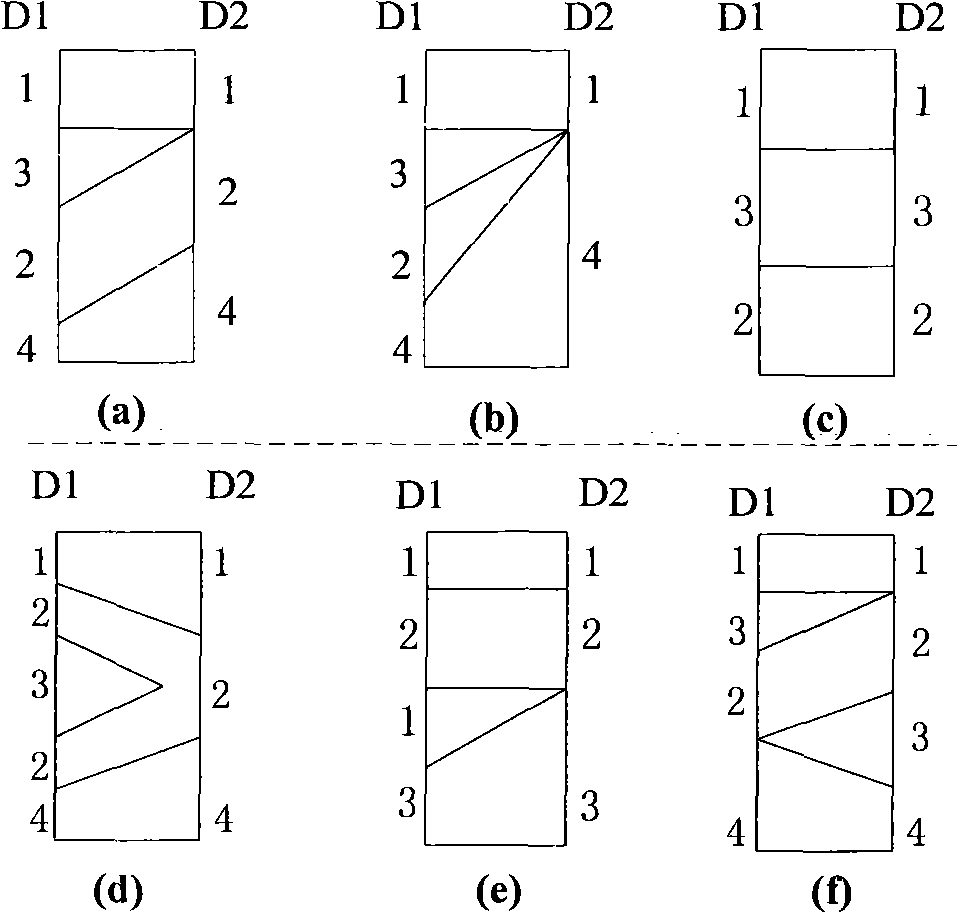
[0059] This example uses Figure 4 The two boreholes shown are connected and filled, the stratigraphic sequence of borehole LK1 is 13242, and the stratigraphic sequence of borehole LK2 is 12324. The process of using this screening method to connect lines to create districts is as follows:
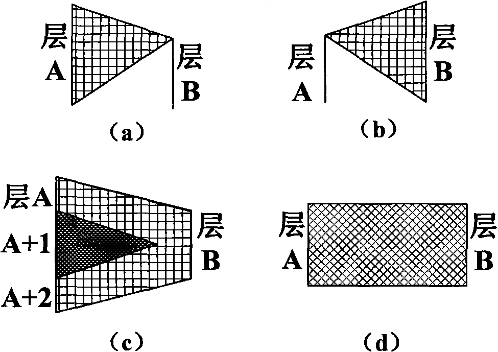
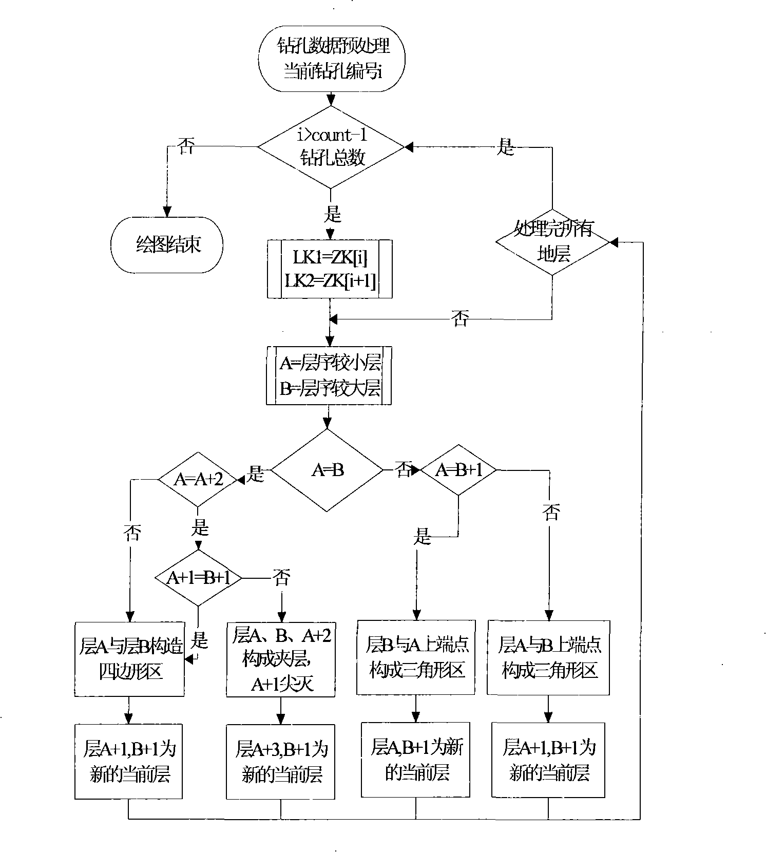
[0060](1) The current layer A is LK1-1, B is LK2-1, the two are the same; go to step (6), the serial number of A+2 is 2 and A is different, so follow figure 2 (d) Connect to build area a, and update A to LK1-2, and B to LK2-2;
[0061] (2) A and B are different, go to step (5); the serial numbers of A and B+1 are both 3, so follow figure 2 (b) Connect to build area b, and update A to LK1-2, and B to LK2-3;
[0062] (3) A and B are the same, go to step (6); the serial number of A+2 is 4 and A is different, so follow figure 2 (d) connect to build area c, and update A to LK1-3, and B to LK2-4;
[0063] (4) A is the same as B, go to step (6); the serial number of A+2 is 2 and A is the s...
Embodiment 2
[0065] In this embodiment, the screening method of digital mapping of complex strata is applied to the development of the underground environmental information system (UEEIS) of the Eastern Reform Project and the development of the highway spatial geographic information visualization management system (HSIVS) of the Guangdong Meihe Expressway Project. The application process is as follows:
[0066] 1. Establish a drilling information database according to the drilling histogram provided by the engineering unit;
[0067] 2. According to the connection drilling specified by the user in the system, the corresponding drilling coordinate data and soil layer information are extracted from the drilling information database, and the stratum information of each drilling is preprocessed:
[0068] (1) Determine the borehole on the leftmost side of the profile as the initial borehole of the algorithm array, and sort the other boreholes according to the distance from the initial borehole f...
PUM
 Abstract
Description
Claims
Application Information
 - R&D
- Intellectual Property
- Life Sciences
- Materials
- Tech Scout
- Unparalleled Data Quality
- Higher Quality Content
- 60% Fewer Hallucinations
Browse by: Latest US Patents, China's latest patents, Technical Efficacy Thesaurus, Application Domain, Technology Topic, Popular Technical Reports.
© 2025 PatSnap. All rights reserved.Legal|Privacy policy|Modern Slavery Act Transparency Statement|Sitemap|About US| Contact US: help@patsnap.com


