Ground, aviation integral autonomous navigation system design method

A technology of an autonomous navigation system and a design method, which is applied in the directions of integrated navigators, radio wave measurement systems, satellite radio beacon positioning systems, etc., to achieve the effects of high positioning accuracy, improved autonomy, and high reliability

Inactive Publication Date: 2010-11-17
SHANGHAI INST OF TECHNICAL PHYSICS - CHINESE ACAD OF SCI
View PDF0 Cites 0 Cited by
  • Summary
  • Abstract
  • Description
  • Claims
  • Application Information

AI Technical Summary

Problems solved by technology

[0007] The purpose of the present invention is to provide a method for designing an autonomous navigation system to solve the problem of autonomous navigation of deep space aircraft

Method used


Image

  • Ground, aviation integral autonomous navigation system design method
  • Ground, aviation integral autonomous navigation system design method
  • Ground, aviation integral autonomous navigation system design method

Examples


Embodiment Construction

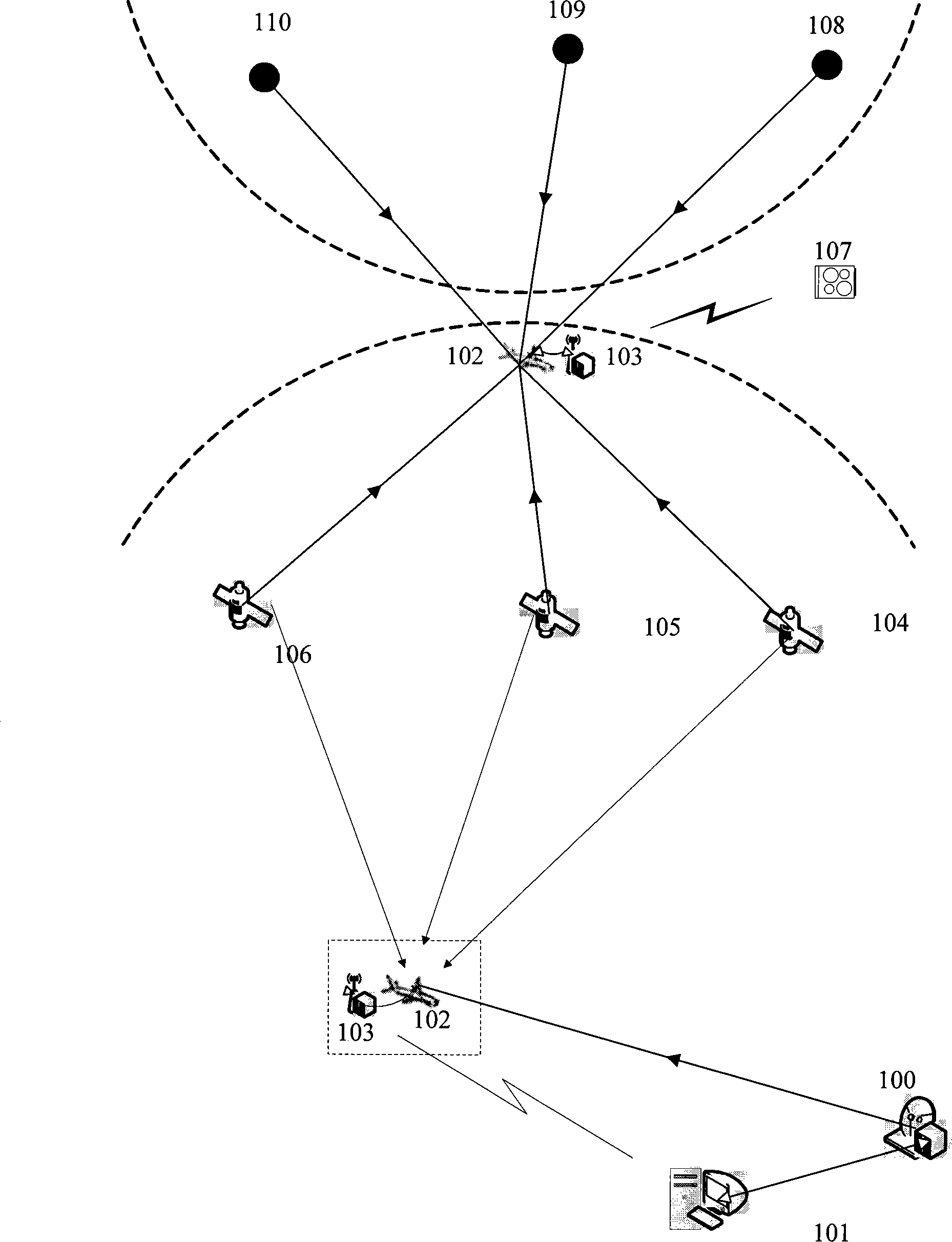
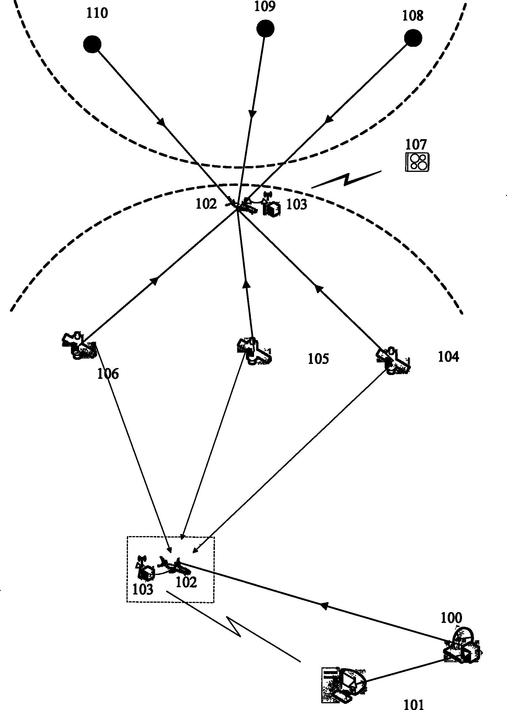
[0039] refer to figure 1 , figure 2 , in conjunction with the navigation requirements of deep-space aircraft, the specific implementation and operation of the method of the present invention are carried out as a case study:

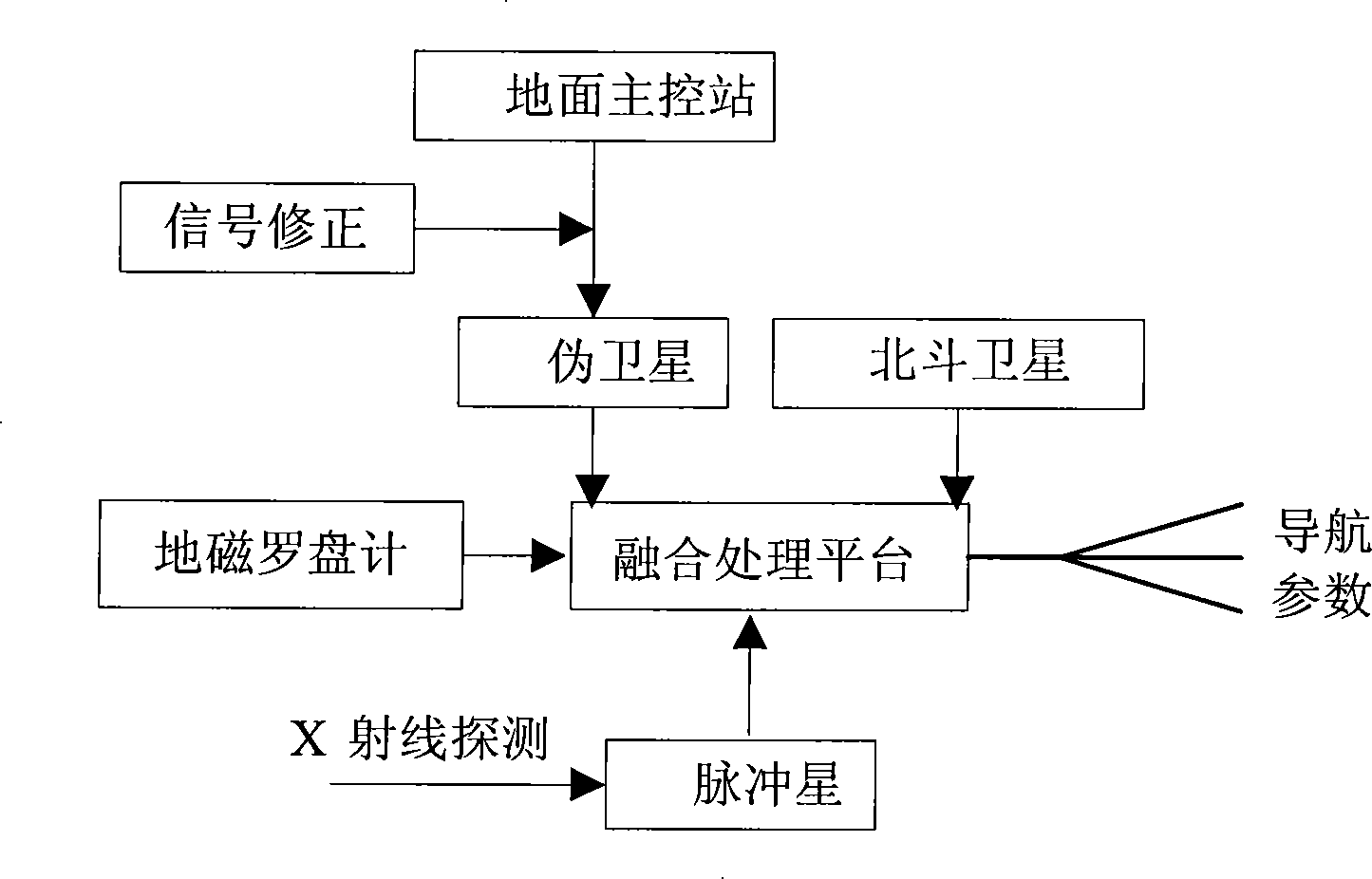
[0040] (1) The deep-space aircraft 102 is launched on the ground to the space between the navigation and positioning satellites 104, 105, and 106. The navigation and positioning of the deep-space aircraft 102 relies on the pseudolites 100 and the navigation and positioning satellites 104, 105, and 106. 104, 105, and 106 use GPS satellites or Chinese Beidou satellites. In the joint positioning system of this section, the pseudolite 100 needs to perform time synchronization correction, atmospheric error correction, etc. through the ground master control station 101 . During the flight, the deep-space vehicle 102 turns on its built-in pseudolite 103 to interact with the main control station 101 on the ground.

[0041] (2) The deep-space vehicle 102 flies...


PUM


Abstract

The invention discloses a ground-space-sky integrated autonomous navigation system design method, which is an autonomous navigation system design method that can be applied to the whole process of launching aircrafts from the ground to the deep space for detection. A system at least comprises a pseudo satellite, a pulsar, a ground main control station, an aircraft, etc. The system is combined with an on-orbit operating GPS or Chinese 'Beidou' satellite so as to be integrated into an autonomous navigation positioning system as a whole. The method prospectively fuses the pulsar which is a stable signal source still in physical concepts into the technical category of deep space integrated autonomous navigation. The method systematically solves the integration requirements of the autonomous navigation of deep space aircrafts, effectively realizes the information fusion of a variety of high technology application, and satisfies the high-precision autonomous navigation application of aircrafts in deep space detection activities. Meanwhile, the method is also a new exploration for the expanding study and system method of ground navigation positioning application.

Description

Technical field: [0001] The invention belongs to the technical field of spacecraft autonomous navigation, and specifically refers to a design method for an integrated autonomous navigation system of ground, space and space, which utilizes pseudolites, pulsars and navigation satellites (such as GPS or Beidou) to construct an integrated autonomous navigation system for aircraft High-precision autonomous orbit determination, time synchronization, attitude control and navigation positioning, the system is suitable for all space parts of the ground, near space, low-Earth orbit and deep space where aircraft complete exploration missions. Background technique: [0002] With the development of space information technology, especially the advancement of deep space exploration, and the launch of aircraft from the ground to space and then to the deep space environment, human beings have never stopped the demand for autonomous navigation and the exploration of new models and methods. ...

Claims


Application Information

Patent Timeline
Patent Type & Authority Patents(China)
IPC IPC(8): G01C21/24G01S5/02G01S19/38
Inventor 张雷王建宇戴宁舒嵘
Owner SHANGHAI INST OF TECHNICAL PHYSICS - CHINESE ACAD OF SCI
Why Eureka
Try Eureka