Synthetic aperture radar three-dimensional microwave imaging method for circular track of earth synchronization orbit

A technology of geosynchronous orbit and synthetic aperture radar, which is applied in the radio wave measurement system, radio wave reflection/re-radiation, and re-radiation utilization, etc. It can solve the problem of small observation area, ambiguous phase of elevation information, and difficulty in obtaining high-resolution 3D Information and other issues

Inactive Publication Date: 2011-04-13
INST OF ELECTRONICS CHINESE ACAD OF SCI
View PDF0 Cites 0 Cited by
  • Summary
  • Abstract
  • Description
  • Claims
  • Application Information

AI Technical Summary

Problems solved by technology

[0007] The existing satellite-borne SAR microwave remote sensing technology has problems such as small observation area, long revisit period, difficulty in obtaining high-resolution 3D information, and phase ambiguity in elevation information, which cannot be applied to areas with complex and steep changes in objects such as cities and military bases. , the purpose of the present invention is to carry out large-area fixed-point continuous monitoring and obtain high-resolution three-dimensional information of ground features. Area 3D Microwave Imaging Method

Method used


Image

  • Synthetic aperture radar three-dimensional microwave imaging method for circular track of earth synchronization orbit
  • Synthetic aperture radar three-dimensional microwave imaging method for circular track of earth synchronization orbit
  • Synthetic aperture radar three-dimensional microwave imaging method for circular track of earth synchronization orbit

Examples


Embodiment Construction

[0039] The present invention will be described in detail below in conjunction with the accompanying drawings. It should be noted that the described embodiments are only intended to facilitate the understanding of the present invention, and have no limiting effect on it.

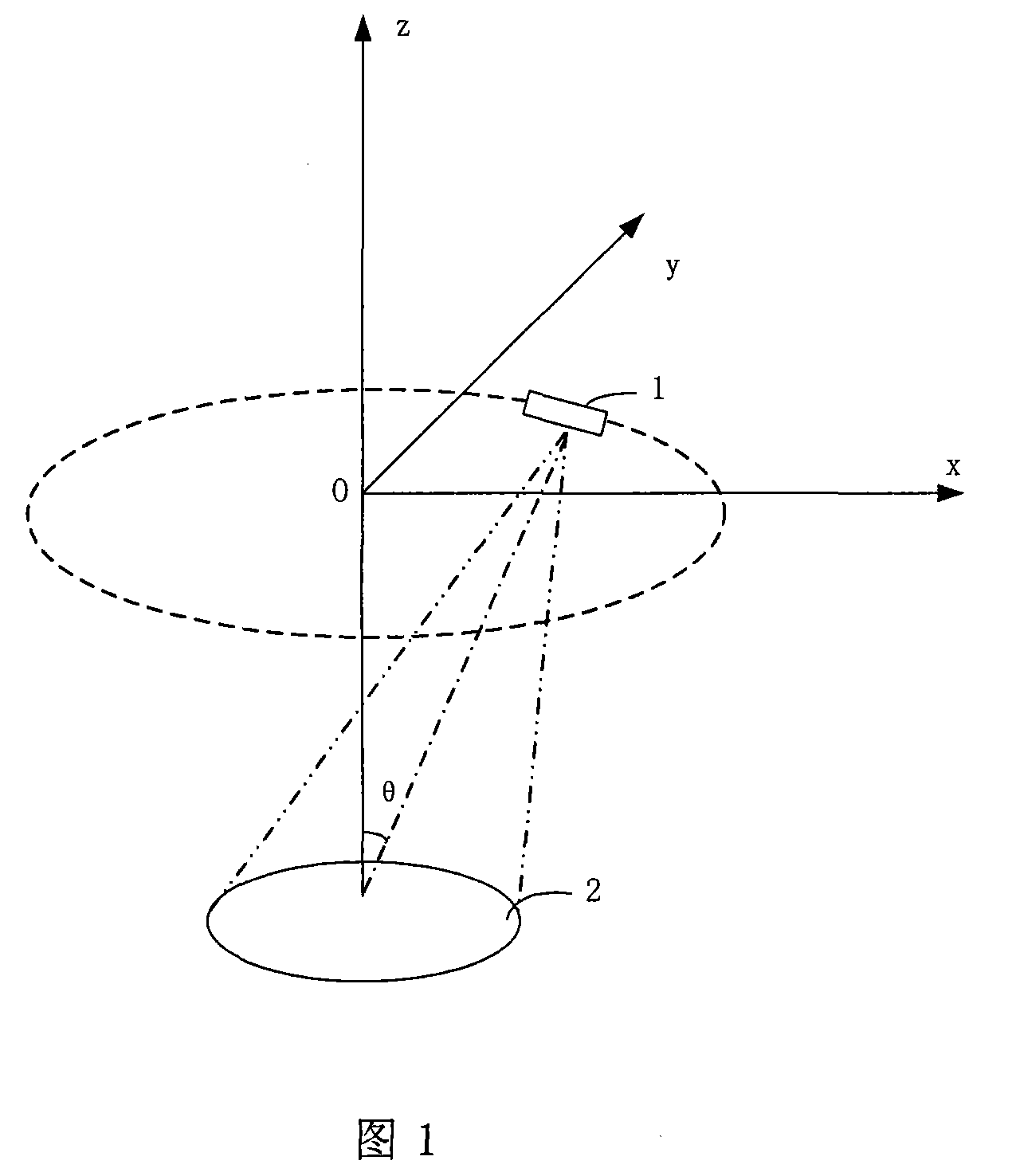
[0040] In the present invention, we propose to use a circular track synthetic aperture radar (Circular SAR, hereinafter referred to as CSAR) mode on a geosynchronous orbit to realize fixed-point observation of the earth and three-dimensional microwave imaging of a large area.

[0041] 1 is a schematic diagram of a circular track synthetic aperture radar (CSAR) according to the present invention. The circular dotted line above is the running track of the SAR platform 1, and the observation area 2 below is the area where the antenna beam is always irradiated. Compared with the conventional strip SAR mode, this CSAR working mode has a very long synthetic aperture length and can obtain the omnidirectional angle in...


PUM


Abstract

The invention discloses a circular synthetic aperture radar (CSAR) 3D microwave imaging method for an earth synchronous orbit. In the method, parameters of the earth synchronous orbit are designed to cause a synthetic aperture radar (SAR) satellite platform to make a flight with an annular track around a target zone and above the target zone, and an antenna beam is caused to irradiate the target zone all the time by a circular synthetic aperture radar mode, and a ground object target is subject to continuous large-area fixed point observation to acquire high-resolution 3D imaging information of the ground object target. A CSAR system of the earth synchronous orbit provided by the system can acquire high-resolution 3D images of the ground object, solves the problem that the existing space-borne SARs are hard to acquire the high-resolution 3D information of the ground object; and is applicable to areas with complex and steep terrains as elevation information does not interfere with phase ambiguity in the SAR. The CSAR system of the earth synchronous orbit can realize the fixed point continuous observation of large-area zones, and solve the problems that the existing space-borne SARshave small observation zones and long revisit period.

Description

technical field [0001] The invention belongs to synthetic aperture radar microwave imaging technology, and relates to a three-dimensional microwave imaging method for spaceborne synthetic aperture radar on orbit. Background technique [0002] Compared with other remote sensing methods, Synthetic Aperture Radar (SAR) microwave imaging technology has the advantages of high resolution, all-time and all-weather, so it has become an important tool for earth observation. To achieve large-area observation of the earth, spaceborne SAR must be used. However, the current spaceborne SAR technology has considerable deficiencies in the scope of the surveying zone, long-term high-repetition observation of the target, and acquisition of three-dimensional information, which seriously limits the application of SAR in military and civilian applications. [0003] All SAR satellites currently in orbit are low-orbit satellites. For a fixed area, the overhead time of low-orbit satellites is ver...

Claims


Application Information

Patent Timeline
Patent Type & Authority Patents(China)
IPC IPC(8): G01S13/90
Inventor 王小青朱敏慧陈永强肖疆
Owner INST OF ELECTRONICS CHINESE ACAD OF SCI
Why Eureka
Try Eureka