Real-time accurate monitoring method for earth crust millimeter-level displacement

A millimeter-level, precise technology, applied in the field of real-time precision monitoring of seismic activity and millimeter-level displacement of the earth's crust, can solve problems such as difficult to be widely promoted, time-consuming, and heavy drilling workload in deep wells

Active Publication Date: 2009-05-13
NAT ASTRONOMICAL OBSERVATORIES CHINESE ACAD OF SCI +1
View PDF2 Cites 26 Cited by
  • Summary
  • Abstract
  • Description
  • Claims
  • Application Information

AI Technical Summary

Problems solved by technology

It is reported that similar deep well drilling surveys have been explored in China, but deep well drilling has a large workload and takes a long time, making it difficult to widely promote

Method used


Image

  • Real-time accurate monitoring method for earth crust millimeter-level displacement
  • Real-time accurate monitoring method for earth crust millimeter-level displacement
  • Real-time accurate monitoring method for earth crust millimeter-level displacement

Examples


specific Embodiment approach

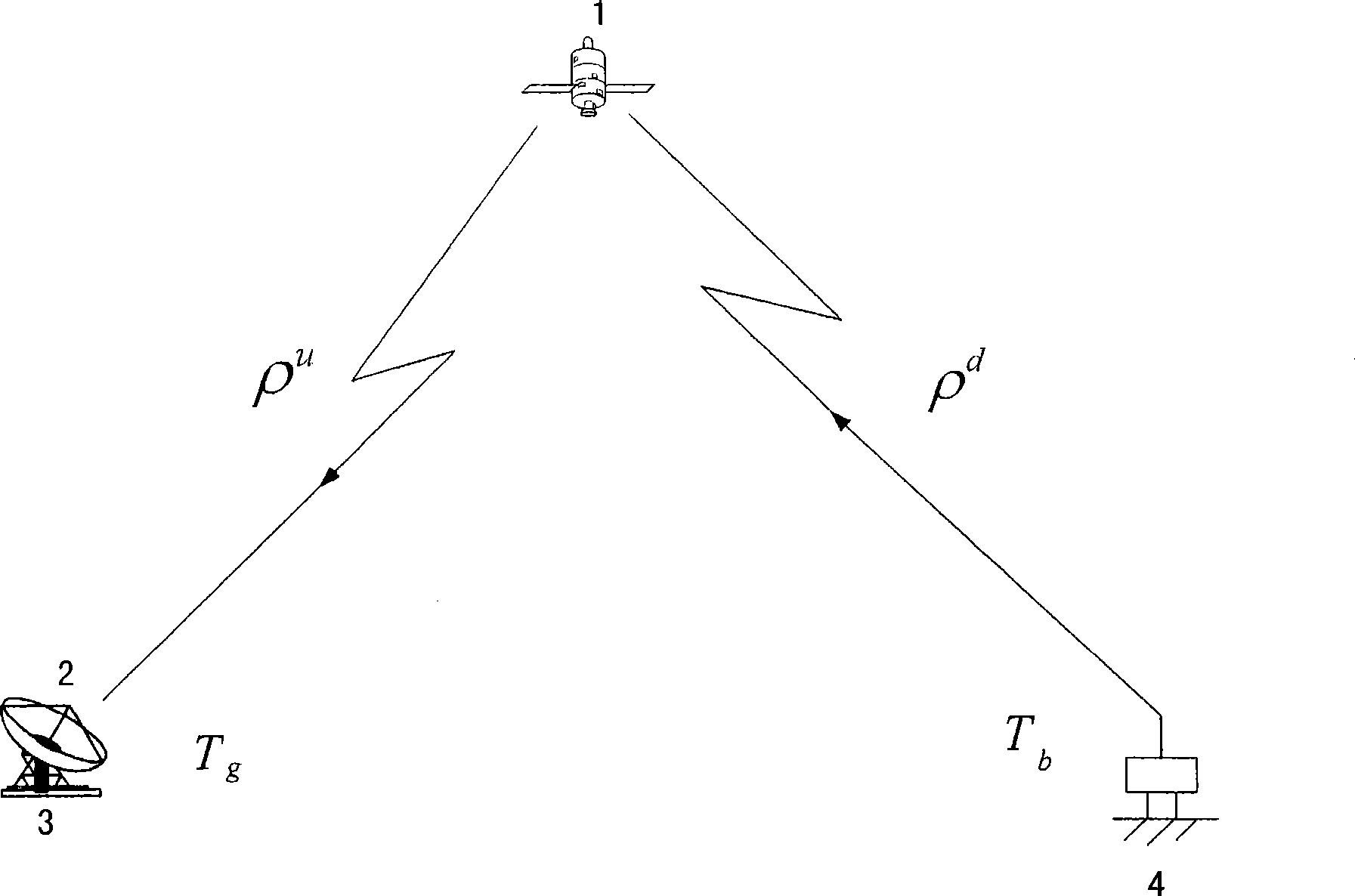
[0151] 1. Measuring system composition plan

[0152] The measurement system consists of three parts: space satellite 1, measurement terminal 4 and central ground station 2 (see Figure 13 ). A brief introduction is given below:

[0153] 1).Satellite 1

[0154] Satellite 1 selects commercial communication satellite 1 or decommissioned satellite 1 on the geostationary orbit (see invention patent 200610055009.2) (such as Asia Pacific 1 satellite, see Figure 13 ), the frequency used is C-band. The decommissioned synchronous communication satellite 1 with rich transponder resources is used to complete the signal transmission, so that the frequency band usage cost is obviously lower than that of commercial synchronous communication satellite 1 . If it is desired to know the individual components of the vibration or the resulting vibration vector, at least three geostationary satellites 1 with co-frequency transponders are required.

[0155]2). Ground central station

[0156] ...


PUM


Abstract

The invention discloses a real-time precision monitoring method of millimeter crustal displacement, and relates to the seismic survey technology, wherein, the method comprises the following steps: 1) emission points are arranged in a large region grid manner, and a microminiature satellite survey terminal is arranged on nodes of a monitoring network; 2) a national ground information processing central station is divided into a center and a regional center; 3) information acquired by the microminiature satellite survey terminal is transmitted to a synchronous communication satellite, then forwarded to a downlink by a satellite repeater, and received by a large antenna in the ground information processing central station, and the data are acquired and processed in a centralized manner; 4) crustal shock parameters of a position at which the survey terminal is positioned are obtained, in which the survey resolution of the displacement and the amplitude are not greater than 1mm, the survey frequency is not greater than 50HZ, and the survey period is not greater than 20ms; and 5) terminal monitoring points are operated in an unmanned manner. The method can help continuously and exactly monitor the movement and variation of the crust in a real time, provides information for predicting and forecasting earthquakes, and can help survey the shock and the displacement of dams, bridges, high-rise buildings, large facilities and the like.

Description

technical field [0001] The invention relates to the field of seismic measurement technology, in particular to real-time precise monitoring of seismic activity, which is a real-time precise monitoring method for millimeter-scale displacement of the earth's crust, which can provide relevant information on earthquake prediction and forecasting, and can be applied due to the accurate measurement of displacement and vibration. It is used in related fields that require displacement and vibration monitoring. Background technique [0002] Earthquakes are one of the most serious natural disasters, similar to those that occurred in Tangshan in 1976, Indonesia in 2004, and Wenchuan in 2008. They will cause houses to collapse, roads to be interrupted, and landslides to occur in a very short period of time. , communication interruption, serious casualties, and extremely heavy losses. Accurate earthquake prediction is very important to alleviate the impact of earthquake disasters, especi...

Claims


Application Information

Patent Timeline
Patent Type & Authority Applications(China)
IPC IPC(8): G01V1/00G01S5/14
Inventor 施浒立韩延本裴军李志刚杨旭海尹志强胡超崔君霞杜晓辉
Owner NAT ASTRONOMICAL OBSERVATORIES CHINESE ACAD OF SCI
Why Eureka
Try Eureka