
Accurate navigation system and method for movable object

A technology of moving objects and navigation methods, applied in the field of navigation, can solve the problems of positioning and navigation without teaching

Inactive Publication Date: 2009-07-08
丘玓 +1
View PDF6 Cites 33 Cited by
  • Summary
  • Abstract
  • Description
  • Claims
  • Application Information

AI Technical Summary

Problems solved by technology

However, there is no teaching in this patent how to perform positioning and navigation in GPS-undetectable areas

Method used


Image

  • Accurate navigation system and method for movable object
  • Accurate navigation system and method for movable object
  • Accurate navigation system and method for movable object

Examples


Embodiment Construction

[0020] The following is a further description of the present invention based on the objectives, effects, configurations, and preferred embodiments of the present invention, together with the drawings, which are not intended to limit the present invention.

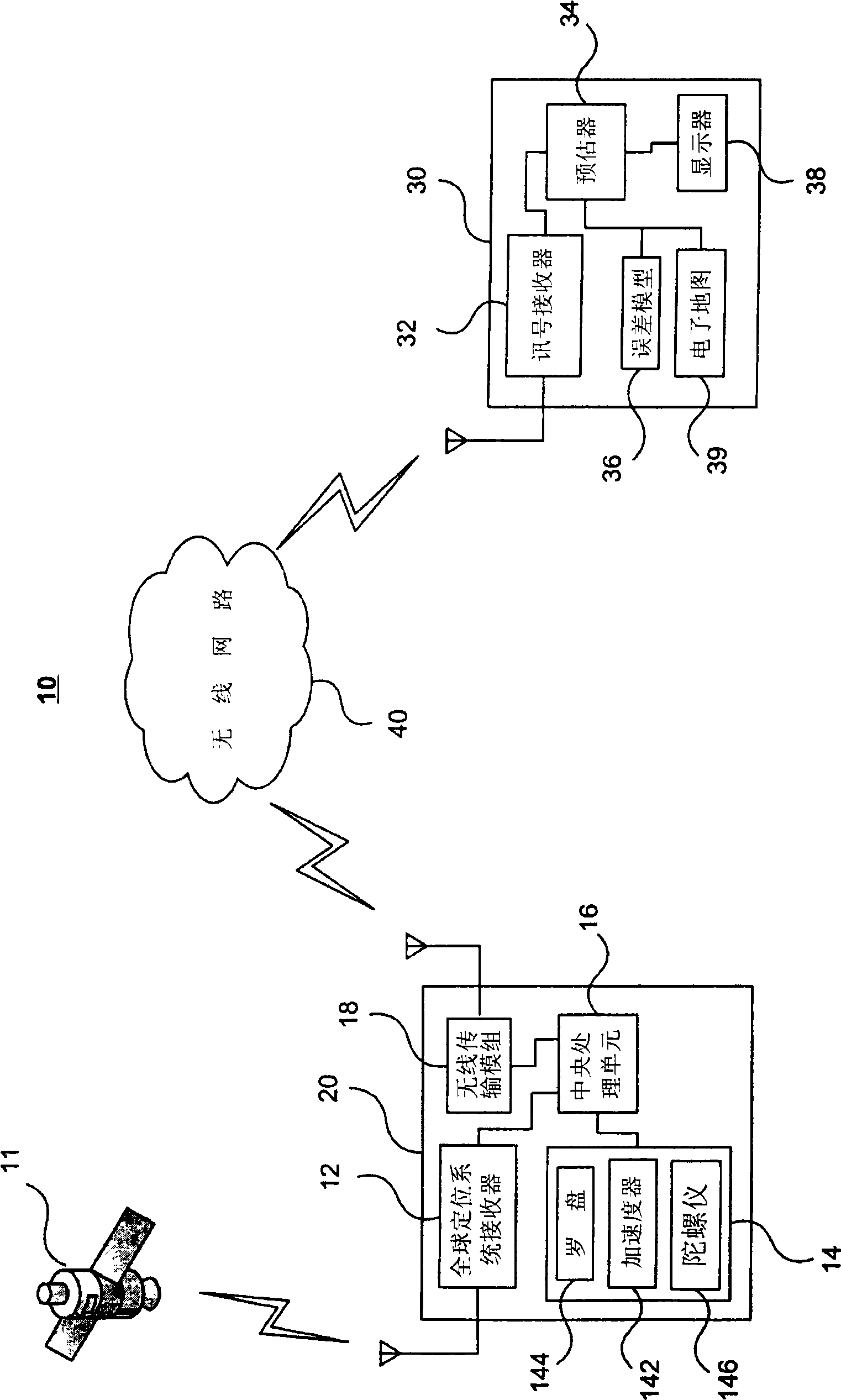
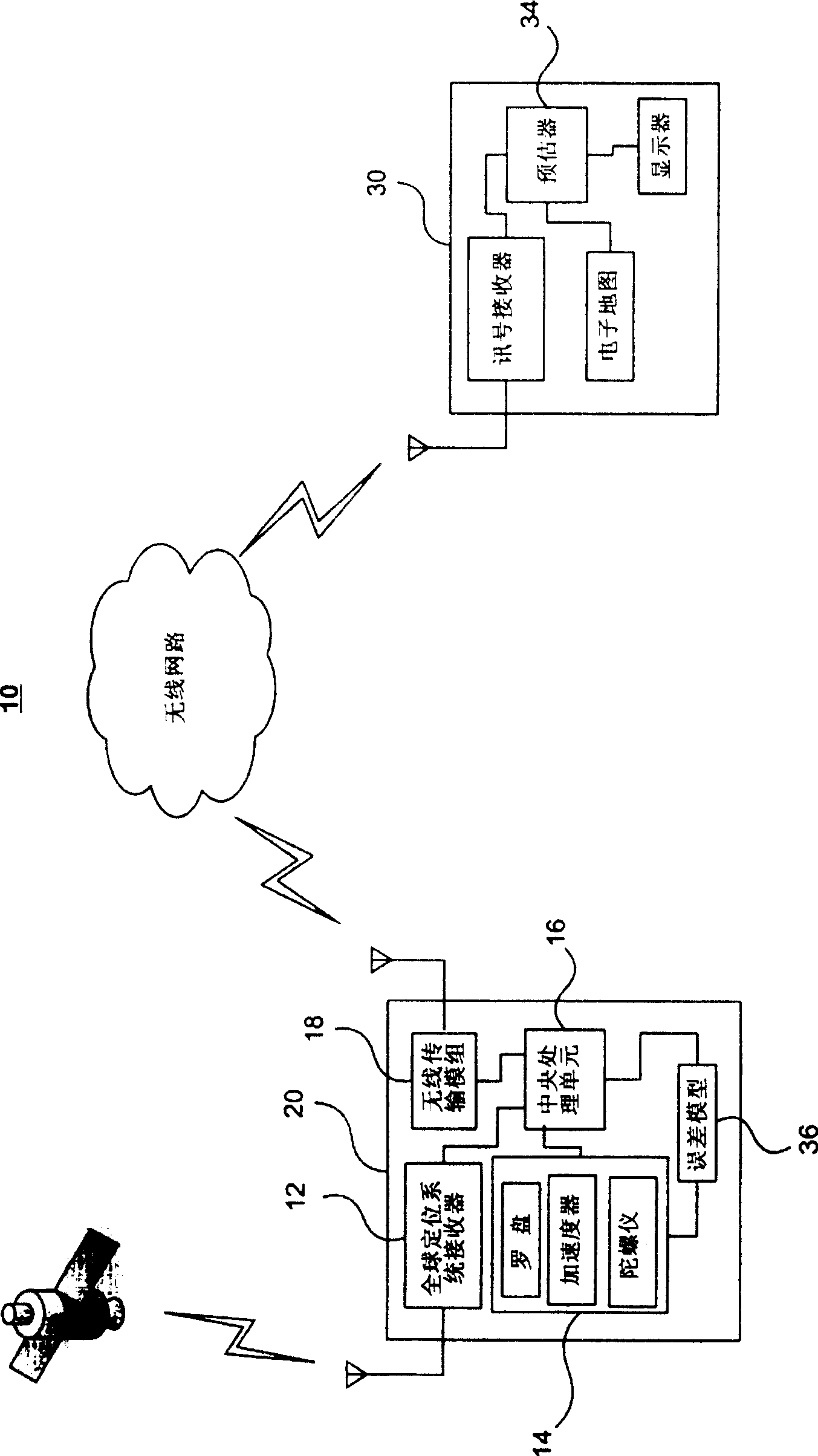
[0021] see figure 1 The navigation system 10 disclosed in the present invention includes a global positioning system receiver (GPS receiver) 12 for receiving position data transmitted from at least one artificial satellite 11; an inertial detection device 14 for detecting the speed of a moving object, distance, direction and angle etc. The moving objects include moving vehicles, moving goods, or moving people.

[0022] The GPS receiver 12 and the inertial detection device 14 are respectively connected to a central processing unit 16 , and the data received by the GPS receiver 12 and the data detected by the inertial detection device 14 are respectively sent to the central processing unit 16 . Wherein, the inertial detecti...


PUM


Abstract

The invention discloses a method for the precise navigation of a moving object, which comprises in a motion process of the object, building an error model by using global positioning system data and inertia detection data and outputting a correction value. When the moving object enters an invisible zone, the correction value and the inertia detection data fuse to generate a predict position. To implement the method, the invention also discloses a precise navigation system, which comprises a front platform for receiving the global positioning system data and generating the inertia detection data, a wireless network and a rear platform, wherein the data can be transmitted to the rear platform through the wireless network, the error model is configured on the front platform or the rear platform, and the rear platform is provided with a predictor which can fuse the correction value output by the error model and the inertia detection data to generate a predict position.

Description

technical field [0001] The present invention relates to a navigation method and system, in particular to a navigation method and system capable of accurately locating a moving object in an invisible area. Background technique [0002] The Global Positioning System (GPS) is a known navigation system that enables accurate positioning of moving objects in areas where satellite signals are available; however, in areas where satellite signals are not available, such as basements, tunnels, Or if there is interference and shadowing, the satellite signal will fail and positioning cannot be performed. [0003] An inertial navigation system (INS) is another known navigation system that allows automatic operation and is independent of terrain. After initializing the starting point, the inertial navigation system can output information such as the position, speed, and direction of the moving object. However, its navigation solution will drift with time, making the navigation error inc...

Claims


Application Information

Patent Timeline
Patent Type & Authority Applications(China)
IPC IPC(8): G01C21/00G01S5/02G01C21/16G01C21/28
Inventor 丘玓田丰周元玉
Owner 丘玓
Learn More