Farmland pollution area following system by wireless sensor network and method thereof

A wireless sensor and polluted area technology, applied in the field of wireless sensor network farmland polluted area tracking system, can solve the problem of lack of ranging methods

Active Publication Date: 2009-10-14
GUANGDONG UNIV OF TECH
View PDF0 Cites 22 Cited by
  • Summary
  • Abstract
  • Description
  • Claims
  • Application Information

AI Technical Summary

Problems solved by technology

The wireless sensor network farmland pollution area tracking system belongs to the outdoor wireless sensor network positioning system. At present, the outdoor wireless sensor network positioning technology still lacks a more effective and accurate ranging method to accurately determine the wireless sensor network positioning

Method used


Image

  • Farmland pollution area following system by wireless sensor network and method thereof
  • Farmland pollution area following system by wireless sensor network and method thereof
  • Farmland pollution area following system by wireless sensor network and method thereof

Examples


Embodiment Construction

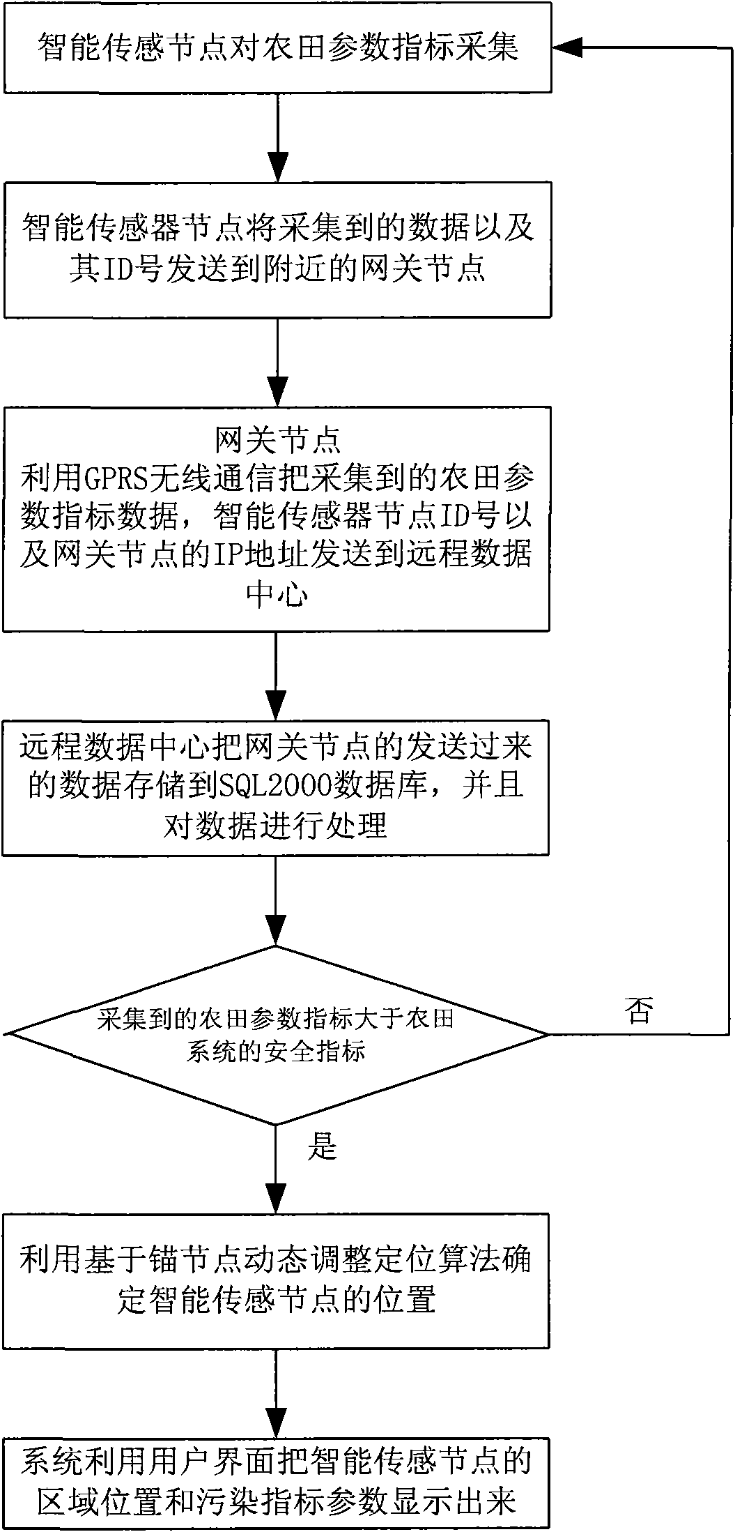
[0054] figure 1 It is a flowchart of a wireless sensor network farmland polluted area tracking system based on dynamic adjustment of anchor nodes. The system includes the following steps:

[0055] 1. Intelligent sensor nodes collect farmland parameters;

[0056] 2. The smart sensor node sends the collected data and its ID number to the nearby gateway node;

[0057] 3. The gateway node uses GPRS wireless communication to send the collected farmland parameter index data, the ID number of the smart sensor node and the IP address of the gateway node to the remote data center;

[0058] 4. The remote data center stores the data sent by the gateway node into the SQL2000 database, and processes the data;

[0059] 5. Judging whether the collected farmland parameter index is greater than the safety index of the farmland system; if it is smaller than the safety index of the farmland system, repeat step 1;

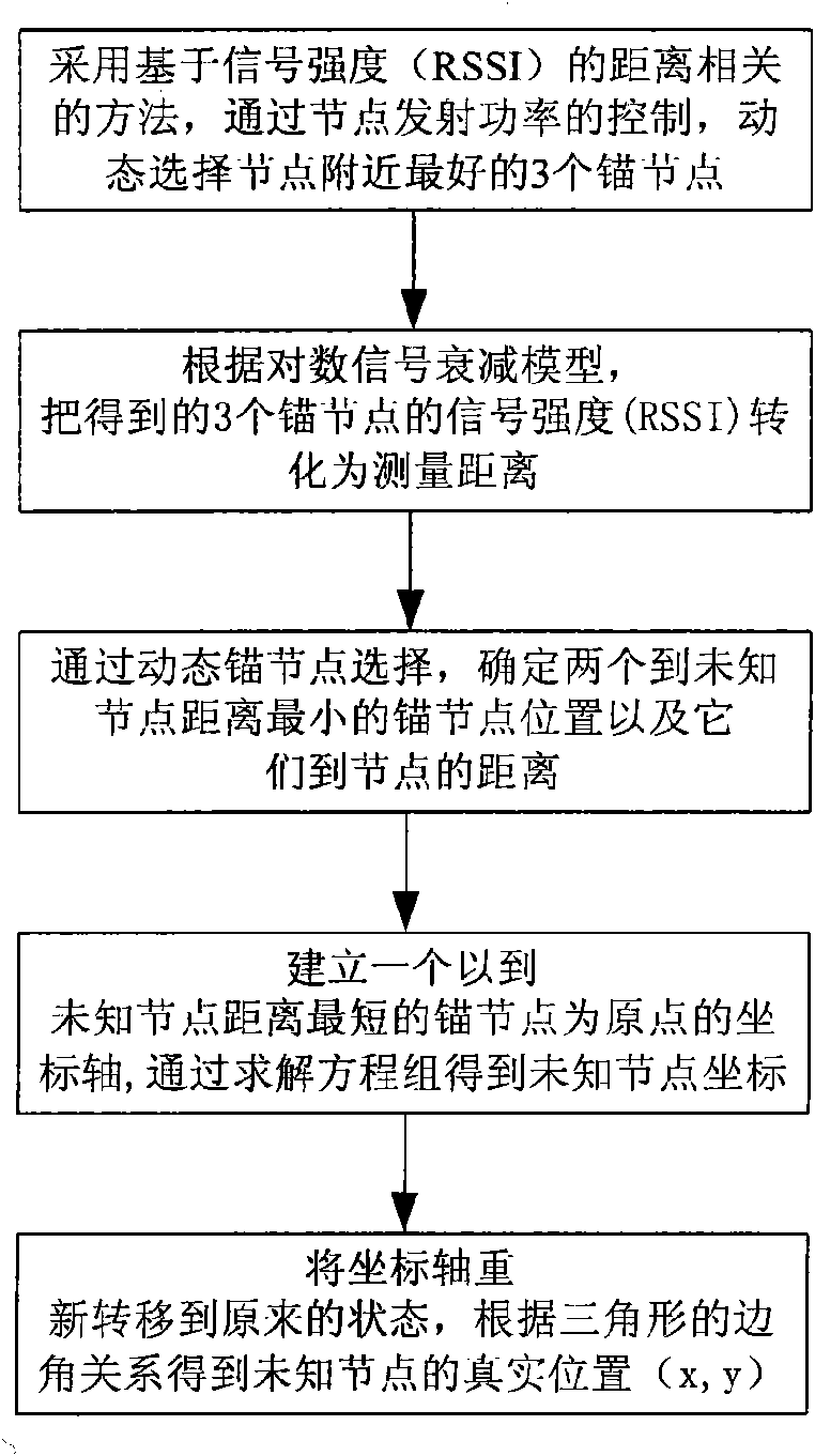
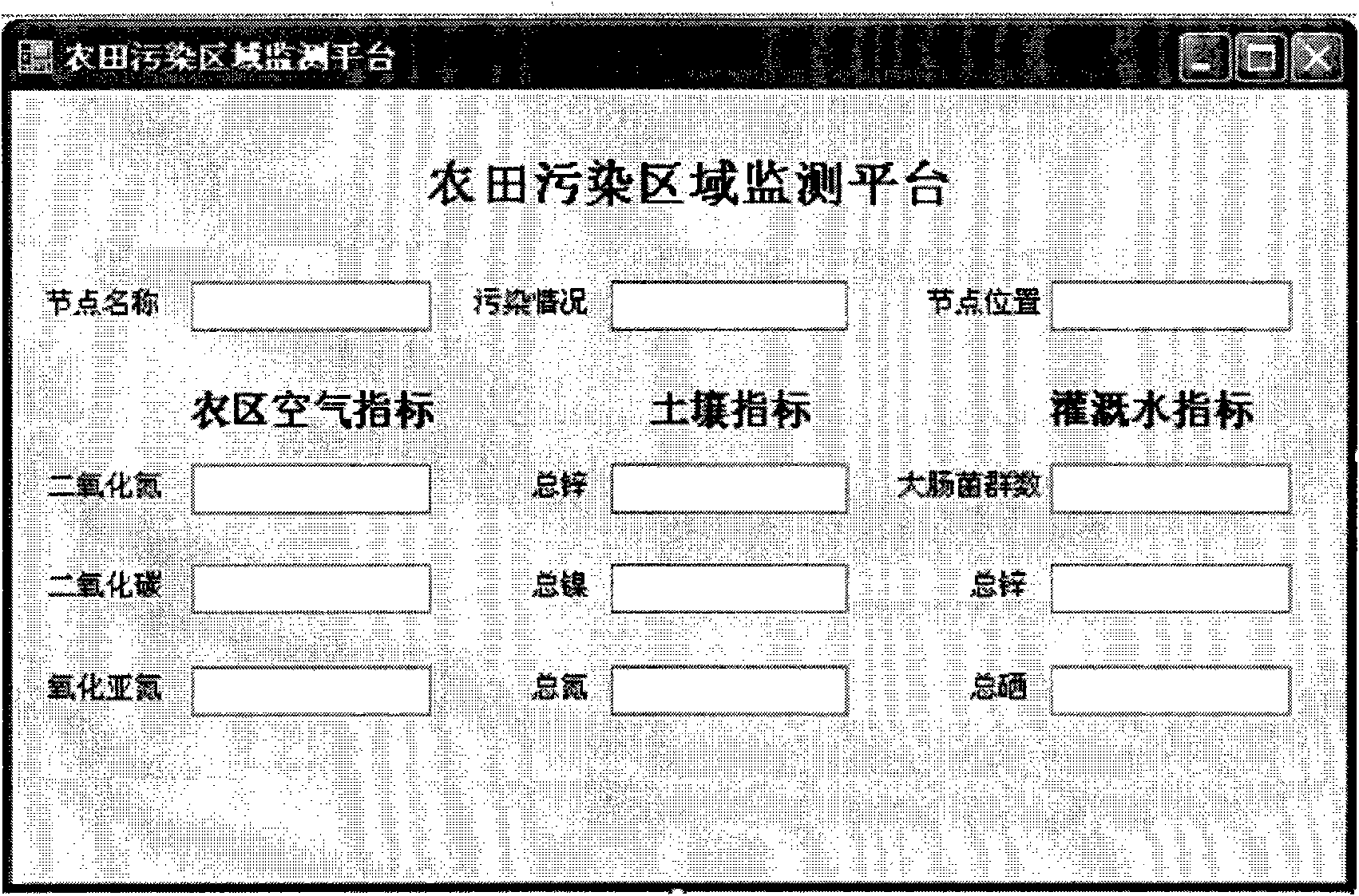
[0060] 6. If it is greater than the safety index of the farmland system, use ...


PUM


Abstract

The invention relates to a farmland pollution area following system by a wireless sensor network, comprising an intelligent sensor node which collects farmland parameter indexes, a gateway node which receives the collected farmland parameter index data and ID number of the intelligent sensor node and a remote data center which receives and processes the collected farmland parameter index data, ID number of the intelligent sensor node and IP address of the gateway node; wherein, the remote data center conducts space-time analysis on the information of the intelligent sensor node through a user interface and displays the information. The system is accurate in positioning, can realize self-adjusting positioning algorithm in the mobile network environment and can resist all kinds of disturbances of the external environment. The invention also discloses a farmland pollution area following method by the wireless sensor network.

Description

technical field [0001] The invention belongs to wireless sensor networks, in particular to a wireless sensor network farmland polluted area tracking system and method thereof. Background technique [0002] A wireless sensor network is a network composed of a large number of tiny nodes integrated with sensors, data processing units and wireless communication modules through self-organization (Ad hoc). It integrates sensor technology, embedded computing technology, modern network and wireless communication technology, distributed information processing technology, and has very broad application prospects. At the same time, it has potential practical value in many important fields such as military defense, industry and agriculture, urban management, biomedicine, environmental monitoring, emergency rescue, anti-terrorism, and remote control in dangerous areas. [0003] In terms of agriculture, agriculture is the foundation of the national economy, and the sustainable developmen...

Claims


Application Information

Patent Timeline
Patent Type & Authority Applications(China)
IPC IPC(8): H04W84/18G08C17/02H04L29/08
Inventor 程良伦黎大鹏衷柳生
Owner GUANGDONG UNIV OF TECH
Why Eureka
Try Eureka