Land evaluation index classification quantitative method based on spatial data field

A technology of spatial data field and evaluation index, applied in data processing applications, electrical digital data processing, special data processing applications, etc., can solve the problem of lack of action mechanism, Euclidean geometric space distance cannot reflect the actual path, and it is difficult to reveal the influence of factors. substantive issues

Inactive Publication Date: 2009-12-09
WUHAN UNIV
View PDF0 Cites 15 Cited by
  • Summary
  • Abstract
  • Description
  • Claims
  • Application Information

AI Technical Summary

Problems solved by technology

In general, the traditional methods of quantifying the role of land evaluation factors lack the analysis of the mechanism of action between land use demand and land characteristic attributes, as follows: ① there is a lack of unified measurement space for the quantification of evaluation indicators of different types and scales; ② Existing quantification methods mostly use hypothetical, ideal and uniform geographic space to determine the area of ​​action and the maximum radius of influence, ignoring the non-uniform influence of natural and socioeconomic factors such as roads, rivers, mountains, and population density on location. (Anisotropy) ③The linear distance between the...

Method used


Image

  • Land evaluation index classification quantitative method based on spatial data field
  • Land evaluation index classification quantitative method based on spatial data field
  • Land evaluation index classification quantitative method based on spatial data field

Examples


Embodiment Construction

[0056] The method of the present invention will be further described below in conjunction with the accompanying drawings and specific embodiments.

[0057] A method for classifying and quantifying land evaluation indicators based on spatial data fields, comprising the following steps:

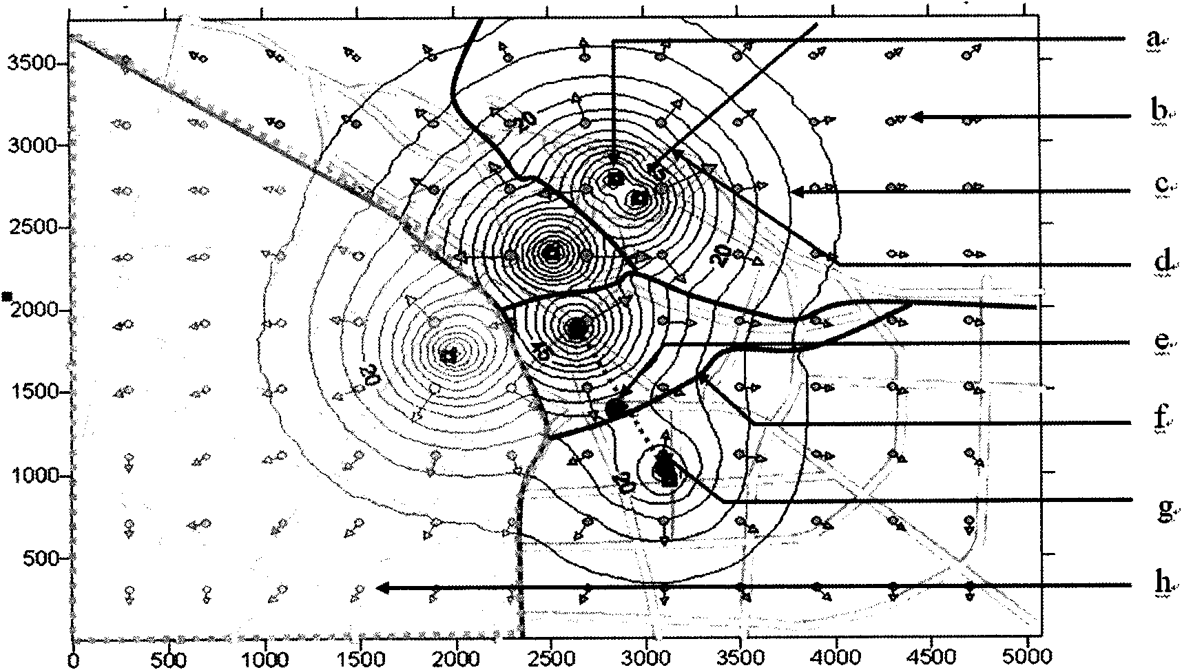
[0058] (1) The construction of land evaluation spatial data field. The land evaluation spatial data field is centered on the interaction between land quality and land use factors, and describes the physical carrier, interaction, economic relationship, spatial The space-time configuration of motion and field characteristics is a system functional structure that uniformly describes the interdependent state of land quality and spatial economic system. as attached figure 1 As shown, field source (a), vector line (b), equipotential line (c), gradient line (d), field field, equilibrium point (e), equilibrium line (f), competition line (g), action Domain (h) and other graphic methods describe the s...


PUM


Abstract

The invention discloses a land evaluation index classification quantitative method based on spatial data field, the method comprises the following steps: (1) constructing a land evaluation spatial data field; (2) classifying land evaluation spatial data field source; (3) classifying and quantizing the land evaluation index based on the land evaluation spatial data field source. The method leads factors affecting land price and the distribution of the land price to be viewed as a special geographic space data field, different types of the evaluation index are different field sources of land price data field, and according to the radiation characteristics of the data field source, the invention provides a set of land evaluation index classification quantitative method based on spatial data field, so as to provide technical support for quantitative and automatic land evaluation.

Description

technical field [0001] The invention relates to a land evaluation index automatic quantification method, in particular to a land evaluation index classification and quantification method based on a spatial data field, which belongs to the field of land investigation and evaluation. Background technique [0002] The quantification of land evaluation indicators is the key to realize the transformation of land evaluation from qualitative to quantitative, and it is necessary to comprehensively consider the characteristics of the evaluation index itself and its impact on the geographical space of the evaluation. Analyzing and clarifying the spatial mechanism of land evaluation influencing factors is the basis for choosing a reasonable land evaluation index quantification method. The research on the quantification of land evaluation indicators and the division of evaluation units in foreign countries has gone through three stages of development. From the 1950s to the 1970s, the qu...

Claims


Application Information

Patent Timeline
IPC IPC(8): G06Q10/00G06Q50/00G06F17/30G06Q50/26
Inventor 刘耀林唐旭洪晓峰
Owner WUHAN UNIV
Why Eureka
Try Eureka