
Altitude measurement method and altitude measurement system

An elevation measurement and elevation technology, applied in the field of measurement, can solve problems such as measurement speed that are susceptible to environmental occlusion, and achieve the effect of fast and simple measurement process

Inactive Publication Date: 2010-02-24
ALIBABA (CHINA) CO LTD
View PDF0 Cites 10 Cited by
  • Summary
  • Abstract
  • Description
  • Claims
  • Application Information

AI Technical Summary

Problems solved by technology

[0007] Embodiments of the present invention provide a method and system for height measurement, which can overcome the problems in the prior art that are susceptible to environmental occlusion and slow measurement speed when measuring under specific conditions

Method used


Image

  • Altitude measurement method and altitude measurement system
  • Altitude measurement method and altitude measurement system
  • Altitude measurement method and altitude measurement system

Examples


Embodiment 1

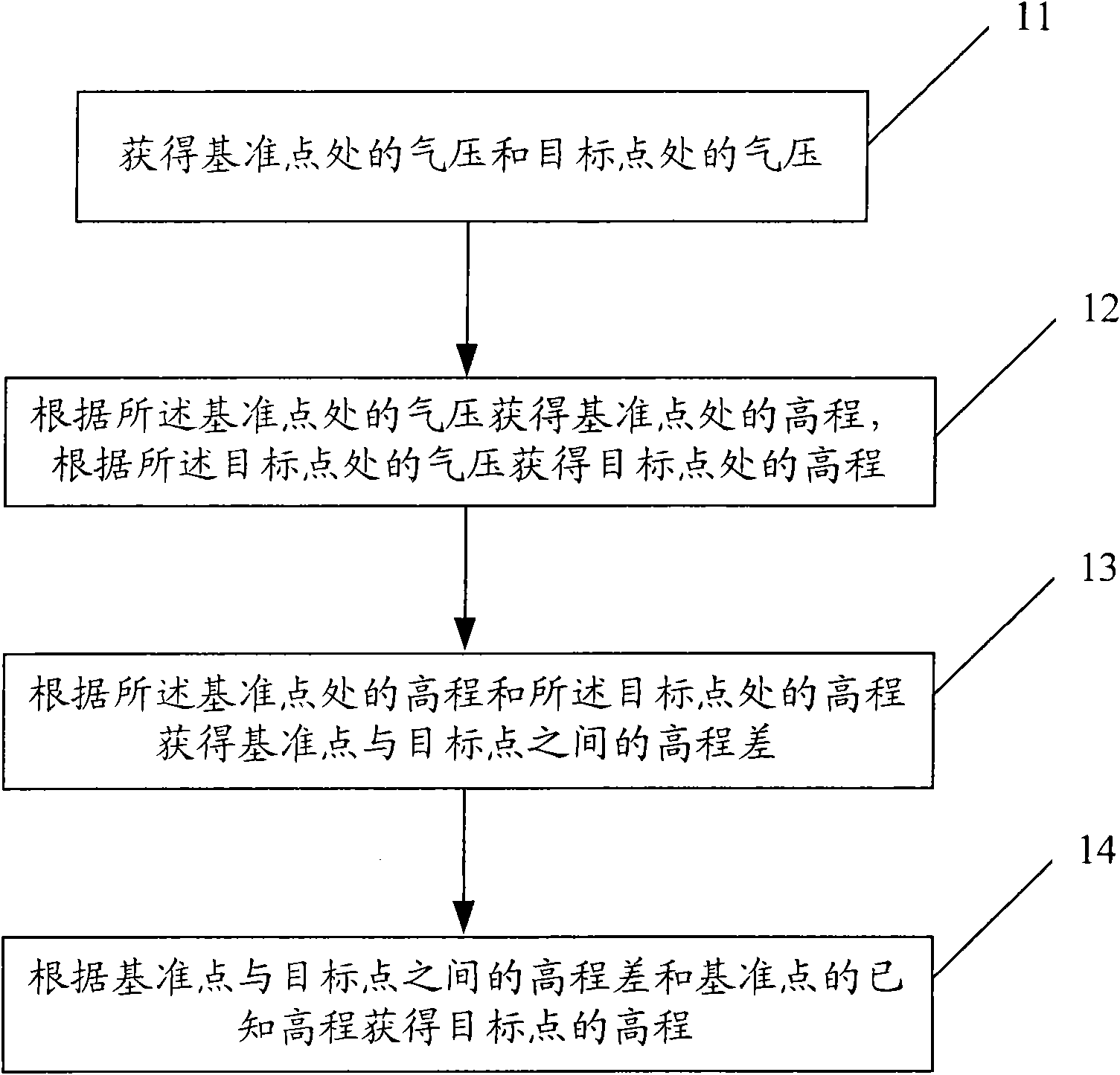
[0021] Such as figure 1 As shown, the present embodiment provides a method for height measurement, comprising the steps of:

[0022] Step 11, obtaining the air pressure at the reference station and the air pressure at the target station.

[0023] The air pressure acquisition device can be used to obtain the air pressure, and the air pressure acquisition device can be composed of a digital air pressure gauge and a PC (Personal Computer, personal computer), wherein the digital air pressure gauge is connected with the PC, the digital air pressure gauge is used for measuring the air pressure, and the PC is used for Obtains the air pressure measured by the digital barometer. One set of air pressure acquisition devices is placed on a reference station whose elevation is known; the other set of air pressure acquisition devices is placed on a target station to be measured as the target station.

[0024] In order to obtain higher measurement accuracy, before the measurement, the time...

Embodiment 2

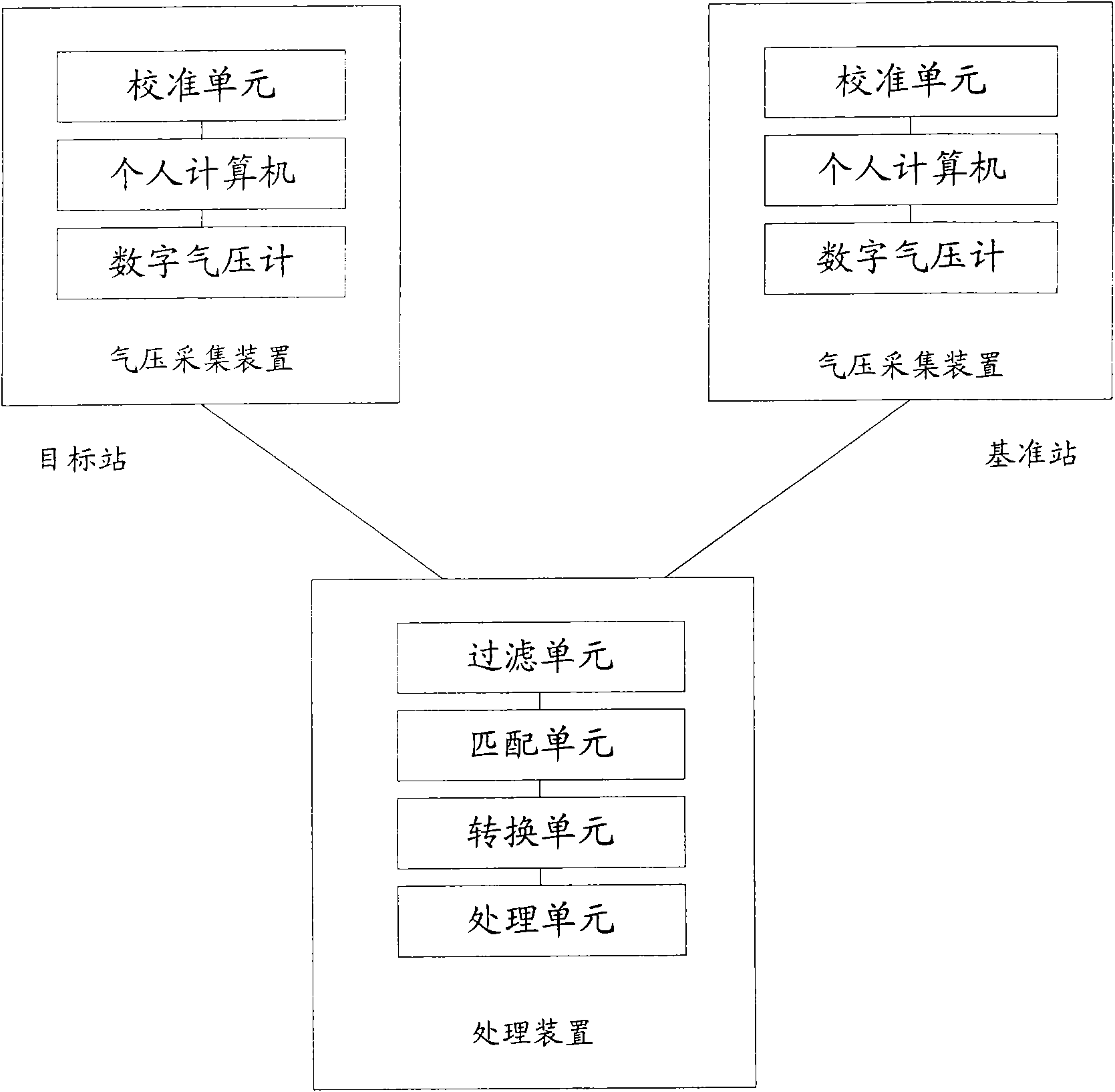
[0160] Such as figure 2 As shown, this embodiment discloses a height measurement system, which includes two sets of air pressure acquisition devices and a processing device; the air pressure acquisition device is used to obtain the air pressure of a digital barometer, wherein one air pressure acquisition device is arranged on a reference station, Another air pressure acquisition device is arranged on the target station; the processing device is used to determine the elevation difference between the reference station and the target station according to the air pressure obtained by the air pressure acquisition device, and according to the known elevation difference and the reference station Elevation Determines the elevation of the target station.

[0161] The air pressure acquisition device comprises a digital barometer and a personal computer, wherein the digital barometer is connected to a PC, the digital barometer is used to measure air pressure, and the personal computer i...


PUM


Abstract

The embodiment of the invention provides an altitude measurement method and an altitude measurement system and solves the problem that in the prior art measurement under a specific condition is susceptible to ambient occlusion and is slow. The method comprises: acquiring the air pressure at the position of a reference station and the air pressure at the position of a target station; acquiring thealtitude of the position of the reference station according to the air pressure at the position of the reference station and acquiring the altitude of the position of the target station according to the air pressure at the position of the target station; acquiring the altitude difference between the reference station and the target station according to the altitudes of the reference station and the target station; and acquiring the altitude of the target station according to the altitude difference between the reference station and the target station and the known altitude of the target station. The system comprises a processor and two sets of air pressure acquisition devices. According to the method and the system, an air pressure gauge is adopted to measure the altitudes, so the measurement of the altitudes can be measured even when the distance between the reference station and the target station is big. And the reference station and the target station are free from limitation of ambient occlusion and the measurement process is quick and simple.

Description

technical field [0001] The invention relates to a measurement technology, in particular to a height measurement method and system. Background technique [0002] Elevation is an important geographic information parameter. When collecting geographic information data, it is usually necessary to collect the elevation of certain geographical locations, such as the height of floors, the elevation of mountains and hills, etc. In the prior art, methods for obtaining elevation include: GPS static positioning elevation measurement method, leveling measurement method and triangular elevation measurement method. The above-mentioned elevation measurement methods are briefly introduced below. [0003] GPS static positioning height measurement method. The scheme adopts differential GPS positioning method and requires two GPSs, one is placed on a point with known elevation as the reference station, and the other is placed on the point to be measured as the target station. Turn on the GPS...

Claims


Application Information

Patent Timeline
IPC IPC(8): G01C5/06
Inventor 杨自华郭飞
Owner ALIBABA (CHINA) CO LTD
Learn More