Implementation method of Street View and implementation system thereof

A street view and map technology, applied in the multimedia field, can solve problems such as complex technology and high system construction costs, and achieve the effects of browsing coherence, reducing construction costs, and saving implementation costs

Inactive Publication Date: 2010-06-02
ZTE CORP
View PDF0 Cites 52 Cited by
  • Summary
  • Abstract
  • Description
  • Claims
  • Application Information

AI Technical Summary

Problems solved by technology

At present, the number of street view map service providers is quite small, one of the important reasons is that due to the complexity of the technology and the high cost of system construction, only a few corporate giants can provide such services

Method used


Image

  • Implementation method of Street View and implementation system thereof
  • Implementation method of Street View and implementation system thereof
  • Implementation method of Street View and implementation system thereof

Examples


Embodiment Construction

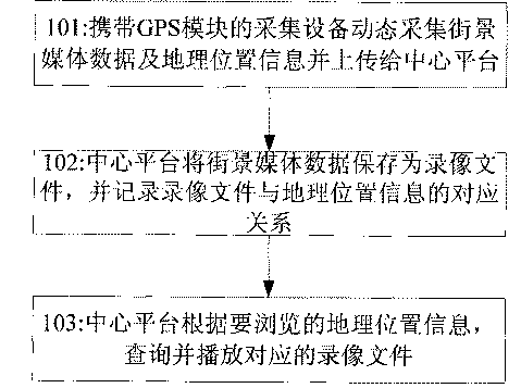
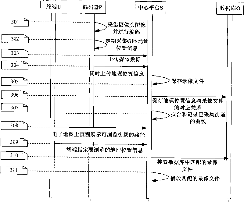
[0041] The implementation method and implementation system of the street view map of the present invention adopts a collection device carrying GPS global positioning system (Global Positioning System) module to dynamically collect street view images and geographic location information, save geographic location information and video files of street view images, and browse according to requirements Play the corresponding video files for the geographic location information, so as to realize the construction and application of street view maps.

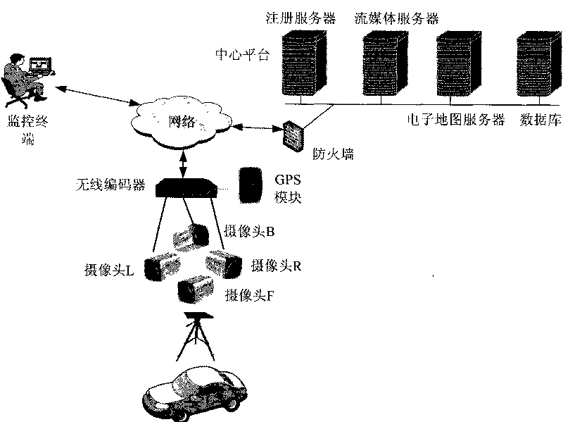
[0042] The realization system of the street view map of the present invention includes a collection device carrying a GPS module and a central platform, such as figure 1 As shown, the implementation method of the street view map of the present invention includes:

[0043] Step 101: A collection device carrying a GPS module dynamically collects street view media data and geographic location information and uploads them to the central platform;

...


PUM


Abstract

The invention discloses an implementation method of Street View, which comprises the following steps: A. a collecting device carrying a GPS module dynamically collects street view media data and geographic location information and submits to a central platform; B. the central platform stores the street view media data as a videotape file and records the corresponding relation between the videotape file and the geographic location information; and C. the central platform inquires and plays the corresponding videotape file according to the geographic location information to be browsed. The inventive implementation method of Street View and implementation system thereof are easy and feasible.

Description

Technical field [0001] The invention relates to the field of multimedia technology, in particular to a realization method and realization system of a street view map. Background technique [0002] With the continuous development of the Internet, people’s applications to the Internet are becoming more and more extensive. Electronic maps are gradually being widely used by people due to their intuitive performance, rich functions, sufficient information, and fast information updates. Using electronic maps, users can easily and quickly perform Inquiries about life information such as geography, location, driving, and public transportation. [0003] Street view map is an application based on electronic map technology that has become popular in recent years. In 2007, Google launched the street view function in its Google Maps and Google Earth products, which made this technology popular rapidly. Street view maps allow users to view everything Choose different locations on the city groun...

Claims


Application Information

Patent Timeline
Patent Type & Authority Applications(China)
IPC IPC(8): G06F17/30G01C21/34
Inventor 陈洁
Owner ZTE CORP
Why Eureka
Try Eureka