
Positioning method of remote sensing image of side-looking radar

A technology of remote sensing image and side-view radar, which is applied in the direction of radio wave reflection/re-radiation, using re-radiation, measuring devices, etc. It can solve the problems of poor precision and applicability, and the inappropriate distance Doppler model positioning method.

Active Publication Date: 2010-11-03
CHINESE ACAD OF SURVEYING & MAPPING
View PDF3 Cites 16 Cited by
  • Summary
  • Abstract
  • Description
  • Claims
  • Application Information

AI Technical Summary

Problems solved by technology

[0005] The purpose of the present invention is to solve the deficiencies of the existing side-looking radar remote sensing image positioning technology based on external orientation elements, and propose a method for image correction and stereo positioning based on distance and coplanar conditions, which overcomes the radar image based on collinear equation model method The rigor and applicability are poor, and the positioning method based on the range Doppler model is not suitable for the shortcomings of the existing photogrammetry data processing algorithm

Method used


Image

  • Positioning method of remote sensing image of side-looking radar
  • Positioning method of remote sensing image of side-looking radar
  • Positioning method of remote sensing image of side-looking radar

Examples


Embodiment Construction

[0031] The present invention will be described in further detail below in conjunction with the accompanying drawings.

[0032]This side-looking radar remote sensing image positioning method uses the outer orientation element of the image as the orientation parameter, and realizes image correction and stereo positioning according to the distance condition and coplanar condition, and overcomes the strictness of the side-looking radar remote sensing image positioning method based on the collinear equation model. Due to the shortcomings of poor performance and applicability, and the method based on the range-Doppler model is not suitable for the existing photogrammetry data processing algorithm, this method is rigorous in both imaging mechanism and data processing method. And like the collinear equation model method, the image point coordinates can be reflected as the attribute of the independent observation value of photogrammetry during photogrammetric adjustment processing, whic...


PUM


Abstract

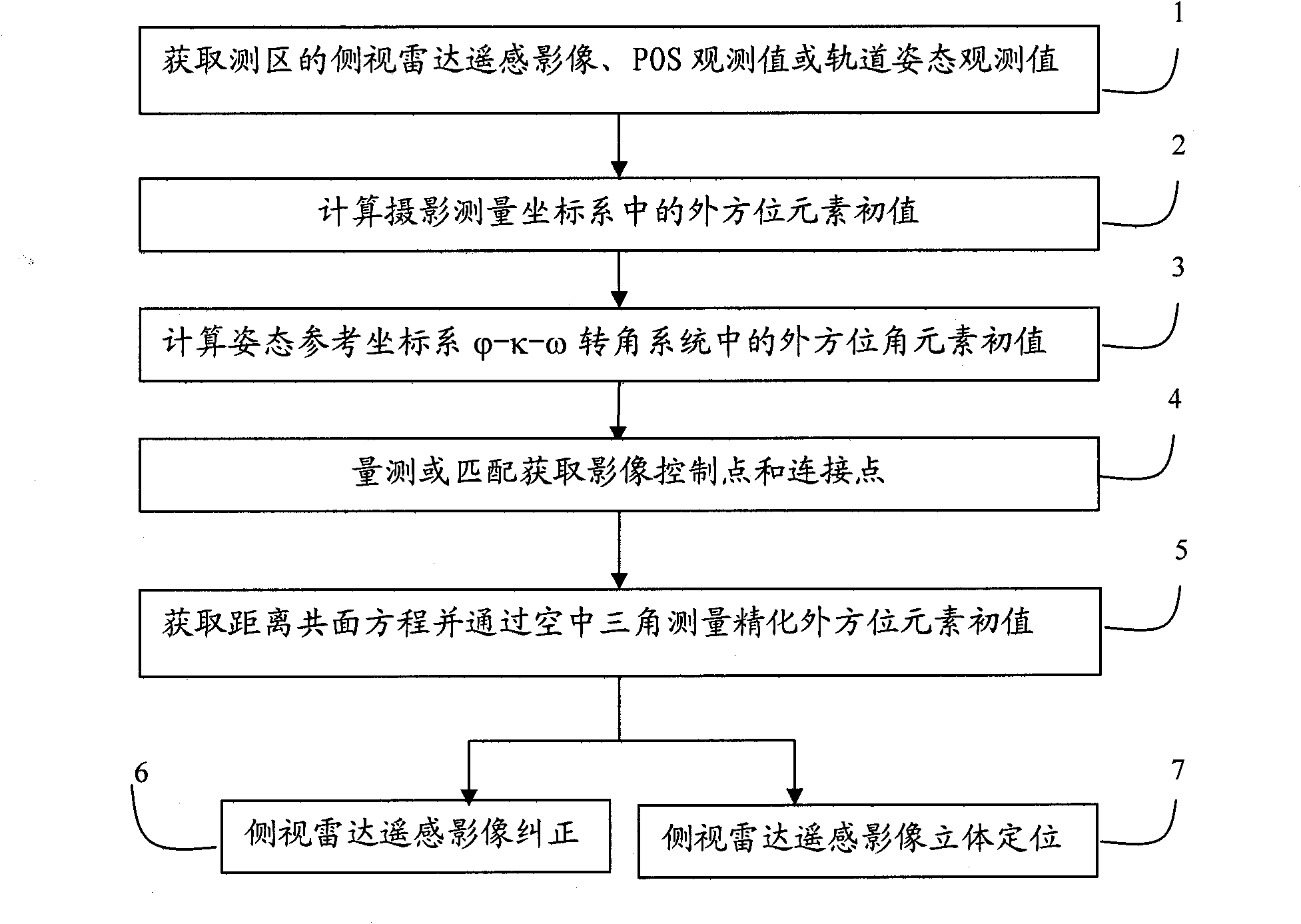
The invention relates to a positioning method of a remote sensing image of a side-looking radar, which takes elements of exterior orientation of the image as orientation parameters and comprises the following steps: (1) acquiring a remote sensing image of a side-looking aerial radar and a POS observed value of a measurement region or a remote sensing image of a side-looking aerial radar and track and attitude observed values; (2) computing the initial values of line elements of exterior orientation in the photogrammetric coordinate system; (3) computing the initial values of angle elements of exterior orientation in the attitude reference coordinate system; (4) measuring or matching control points and connection points of the original image; (5) acquiring a distance-coplanarity equation, and acquiring the refined values of the elements of exterior orientation through aerial triangulation; and (6) correcting the image or three-dimensionally positioning the image according to the refined elements of exterior orientation. The method can improve the accuracy of geometric correction and three-dimensional positioning of the remote sensing image of the current side-looking radar; the provided scheme can perform important functions in orientation, baseline solution, geometric correction and ground three-dimensional reconstruction of the image of a real aperture radar and the remote sensing image of a synthetic aperture radar; and the invention has better technical effect.

Description

technical field [0001] The invention belongs to the field of digital photogrammetry of remote sensing images, in particular to geometric correction and three-dimensional reconstruction methods of side-view radar remote sensing images (including real aperture radar and synthetic aperture radar). Background technique [0002] Remote sensing image positioning refers to the technology and method of obtaining the corresponding ground point plane or three-dimensional coordinates of the image through certain means. Generally speaking, the remote sensing image positioning methods based on strict models are all based on strict construction equations. The construction equations link ground point coordinates and image point coordinates together to realize the conversion between ground point coordinates and image point coordinates. Finally, the ground point plane or three-dimensional coordinates corresponding to the more accurate image are obtained. [0003] Generally speaking, the pos...

Claims


Application Information

Patent Timeline
IPC IPC(8): G01S13/06G01S13/90G01S7/02
Inventor 张继贤程春泉张力燕琴黄国满赵争谢文寒艾海滨孙钰珊
Owner CHINESE ACAD OF SURVEYING & MAPPING
Learn More