Positioning method and system
A positioning method and a predetermined area technology, applied in the computer field, can solve problems such as large system overhead, and achieve the effect of reducing system overhead and reducing the amount of calculation
- Summary
- Abstract
- Description
- Claims
- Application Information
AI Technical Summary
Problems solved by technology
Method used
Image

Examples
Embodiment 1
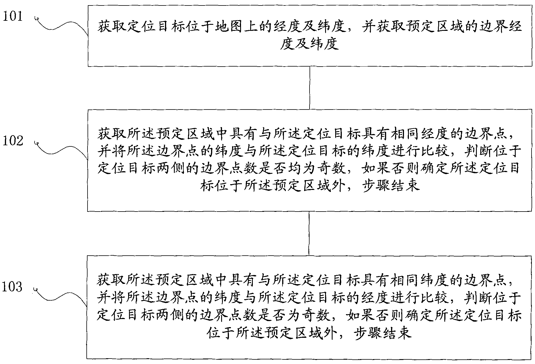
[0042] The first embodiment of the present invention proposes a positioning method, the process of which is as follows image 3 shown, including:
[0043] Step 101, obtaining the longitude and latitude of the positioning target on the map, and obtaining the boundary longitude and latitude of the predetermined area;
[0044] Step 102: Obtain the boundary points in the predetermined area that have the same longitude as the positioning target, and compare the latitude of the boundary points with the latitude of the positioning target, and determine whether the number of boundary points on both sides of the positioning target is are all odd numbers, if otherwise it is determined that the positioning target is located outside the predetermined area, the step ends;
[0045] Step 103: Obtain boundary points in the predetermined area that have the same latitude as the positioning target, and compare the longitude of the boundary points with the longitude of the positioning target, an...
Embodiment 2
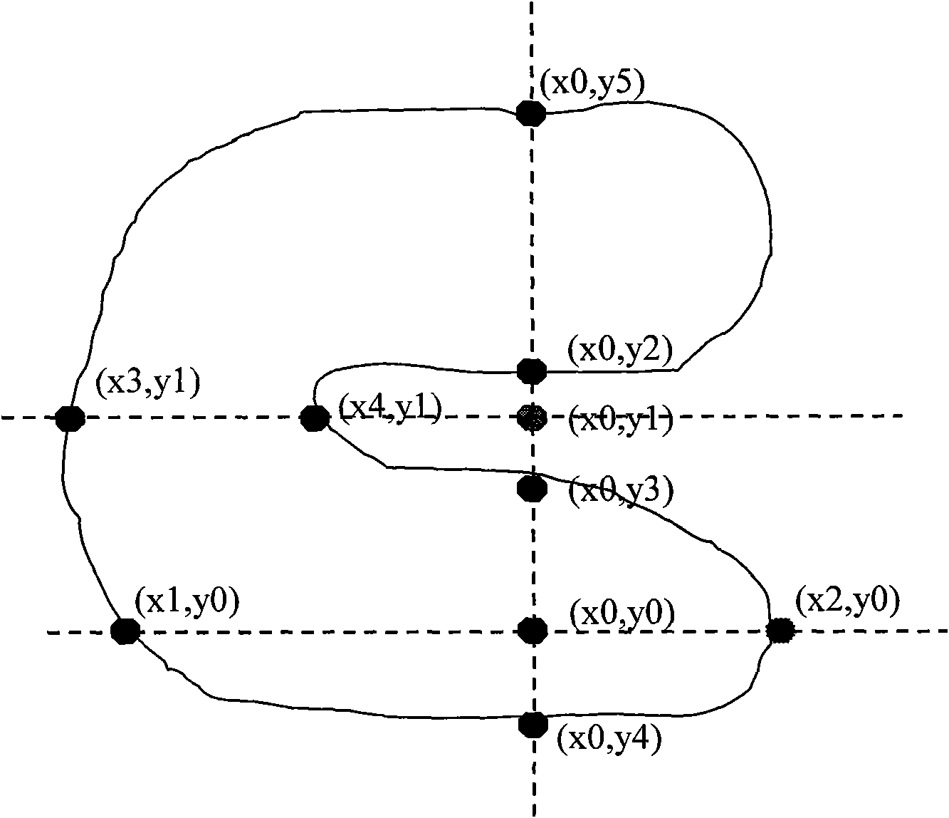
[0048] The second embodiment of the present invention is improved on the basis of the first embodiment. In the first embodiment, it is proposed to judge whether the boundary points located on both sides of the positioning target are odd numbers respectively through the east-west direction and the north-south direction, then the specific implementation method can adopt the following technical solutions, and its process is as follows Figure 4 shown, including:
[0049] Step 201, obtaining the longitude and latitude of the positioning target on the map, and obtaining the boundary longitude and latitude of the predetermined area;
[0050] Step 202: Determine the position of the positioning target on the GIS map according to the longitude and latitude of the positioning target;
[0051] Wherein, both step 201 and step 202 are prior art, and those skilled in the art can simply mark the predetermined area and positioning target on the existing GIS map according to the prior art;
[...
Embodiment 3
[0073] The third embodiment of the present invention proposes a positioning system, the structure of which is as follows Figure 5 shown, including:
[0074] Coordinate acquisition module 1, used to acquire the longitude and latitude of the positioning target on the map, and acquire the boundary longitude and latitude of the predetermined area;
[0075] The north-south direction determination module 2 is used to obtain the boundary point with the same longitude as the positioning target in the predetermined area, and compare the latitude of the boundary point with the latitude of the positioning target, and determine whether it is located in the north or south of the positioning target Whether the number of boundary points on both sides is an odd number, if not, it is determined that the positioning target is located outside the predetermined area;
[0076] The east-west direction determining module 3 is used to obtain the boundary point having the same latitude as the positi...
PUM
 Abstract
Description
Claims
Application Information
 - Generate Ideas
- Intellectual Property
- Life Sciences
- Materials
- Tech Scout
- Unparalleled Data Quality
- Higher Quality Content
- 60% Fewer Hallucinations
Browse by: Latest US Patents, China's latest patents, Technical Efficacy Thesaurus, Application Domain, Technology Topic, Popular Technical Reports.
© 2025 PatSnap. All rights reserved.Legal|Privacy policy|Modern Slavery Act Transparency Statement|Sitemap|About US| Contact US: help@patsnap.com