
Atmosphere environmental impact assessment system and environmental impact assessment method based on GIS (Geographic Information System) technology and AERMODE model

A model and EIA technology, applied in ICT adaptation, climate sustainability, special data processing applications, etc., can solve the problems of insufficient human-computer interaction and data display, complex steps, and many parameters, and achieve high input efficiency and accurate prediction. The effect of improving the ability of judgment, improving the ability of judgment, and large data coverage

Active Publication Date: 2012-02-22
中冶赛迪重庆环境咨询有限公司 +1
View PDF0 Cites 1 Cited by
  • Summary
  • Abstract
  • Description
  • Claims
  • Application Information

AI Technical Summary

Problems solved by technology

AERMODE is developed in Fortran language, command line interface, due to many parameters and complicated steps, the output result is pure data, which is very insufficient in human-computer interaction and data display, and it is very inconvenient to operate and use. It improves the interactive performance and strengthens the analysis of the result data. The display effect is a common problem that needs to be solved when applying the AERMODE model for environmental impact assessment analysis
[0003] At present, the domestic air pollution source diffusion evaluation system has the following shortcomings: it is not convenient to input the topographic data of the prediction point without the introduction of GIS technology, and the effect and function are poor; the local pollution source, weather, and prediction point database have not been established, and Realize the automatic update of pollution sources and meteorological data, and there is still room for improvement in the convenience of user input; when generating concentration contours from the prediction results, there is no choice of interpolation method, which is not convenient for users to judge the accuracy of the results

Method used


Image

  • Atmosphere environmental impact assessment system and environmental impact assessment method based on GIS (Geographic Information System) technology and AERMODE model
  • Atmosphere environmental impact assessment system and environmental impact assessment method based on GIS (Geographic Information System) technology and AERMODE model

Examples


Embodiment Construction

[0029] Preferred embodiments of the present invention will be described in detail below.

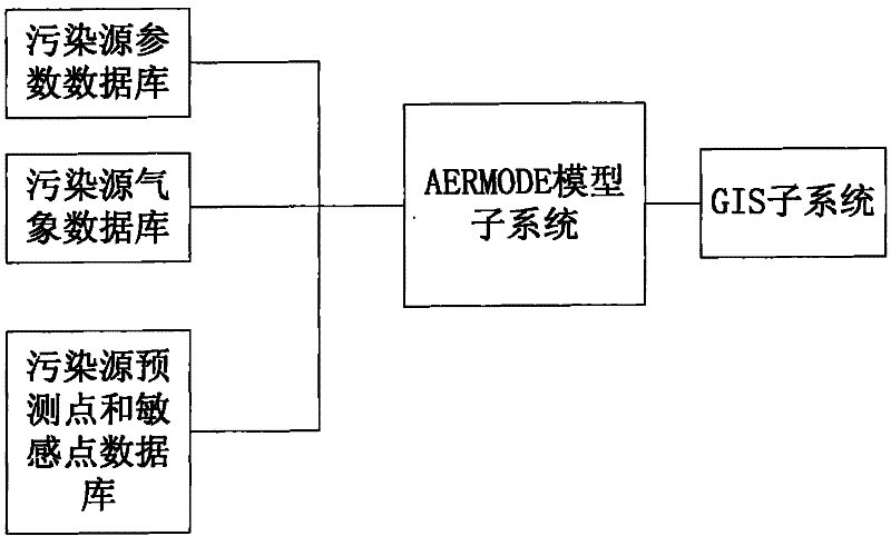
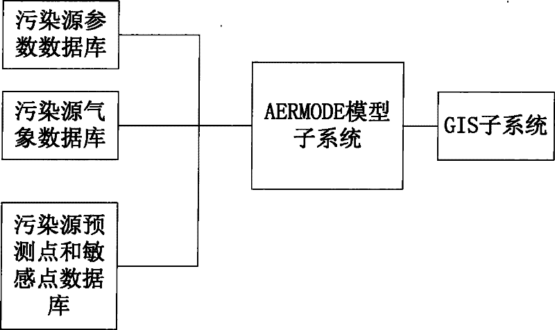
[0030] see figure 1 , the present invention builds an atmospheric environment assessment system based on GIS technology and AERMODE model, including

[0031] Pollution source parameter database, used to store pollution source parameter data that meets the requirements of AERMODE format; real-time collection or manual input of pollution source parameter data, and secondary storage after statistical processing;

[0032] The pollution source meteorological database is used to store the pollution source meteorological data that meets the requirements of the AERMODE format; the accuracy of the meteorological data affects the accuracy of the prediction results. Real-time and historical shared data collection data issued by agencies such as bureaus), if there are high requirements, it is necessary to obtain data or conduct actual measurements from the meteorological department closest to the p...


PUM


Abstract

The invention relates to the technical field of computer environment assessment, in particular to an atmosphere pollution source diffusion assessment system and an assessment method constructed based on a GIS (Geographic Information System) technology and an AERMODE model. The assessment system comprises a pollution source parameter database, a pollution source meteorological database, a pollution source forecast point and sensitive point database, an AERMODE model subsystem and a GIS subsystem, wherein the pollution source parameter database is used for storing pollution source parameter data meeting AERMODE format requirements; the pollution source meteorological database is used for storing pollution source meteorological data meeting the AERMODE format requirements; the pollution source forecast point and sensitive point database is used for storing forecast point and sensitive point data meeting the AERMODE format requirements; the AERMODE model subsystem acquires data from the pollution source parameter database, the pollution source meteorological database and the pollution source forecast point and sensitive point database and operates the AERMODE model for analysis; and the GIS subsystem renders and outputs the analysis result of the AERMODE model subsystem to a map.

Description

technical field [0001] The invention relates to the technical field of computer environment evaluation, in particular to an evaluation system and evaluation method for constructing an air pollution source diffusion evaluation system based on GIS technology and an AERMODE model. Background technique [0002] The technology of conducting diffusion simulation analysis on air pollution sources and conducting environmental impact assessment has important practical value in the field of environmental protection. The Ministry of Environmental Protection's "Technical Guidelines for Environmental Impact Assessment Atmospheric Environment HJ2.2-2008" national standard recommends five diffusion evaluation models (1) Estimation model, which is a single-source prediction model, suitable for determining the evaluation level and evaluation scope, open source ;(2) AERMODE mode, suitable for primary and secondary evaluation projects with an evaluation distance of less than 50KM, which can si...

Claims


Application Information

Patent Timeline
Patent Type & Authority Patents(China)
IPC IPC(8): G06F19/00G06F17/30
CPCY02A90/10
Inventor 张汉荣王志伟谢川唐小健刘艺杜云贵蒋建华周伟张辉蒋晓玲李征曾祥宁郭红宇杨刚宋扬周松张帮均欧阳宏刘昆
Owner 中冶赛迪重庆环境咨询有限公司
Learn More