Remote sensing image road extracting method based on stereo constraint

A remote sensing image and road extraction technology, applied in the field of remote sensing, can solve the problems of low efficiency of road information extraction, classification protocol dependence, etc.

Inactive Publication Date: 2010-12-01
TONGJI UNIV
View PDF5 Cites 32 Cited by
  • Summary
  • Abstract
  • Description
  • Claims
  • Application Information

AI Technical Summary

Problems solved by technology

It is characterized by the refinement of classification, but it relies heavily on the classification protocol (it is better to have protoco

Method used


Image

  • Remote sensing image road extracting method based on stereo constraint
  • Remote sensing image road extracting method based on stereo constraint
  • Remote sensing image road extracting method based on stereo constraint

Examples


Embodiment 1

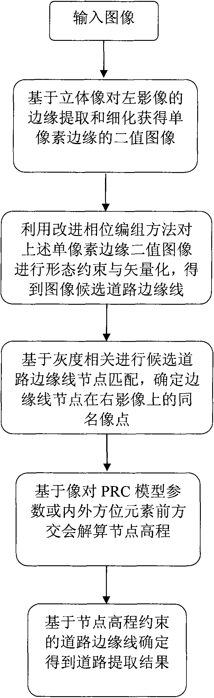
[0054] It is necessary to extract the road edge line from a high-resolution remote sensing image stereo pair through stereo constraints, and obtain road thematic information vector data.

[0055] The experimental image is a stereo pair of Quickbird panchromatic bands. The left image size is 6961*5048, the right image is 6606*5419, and the image pixel resolution is 0.6m. Because the image is too large, the image in the experiment Parts A (on the left image) and B (on the right image) are used for the road edge line extraction experiment. The image sizes of A and B are both 2000*2000 pixels in TIFF format. The pixel coordinates of the upper left corner of image A on the left image of the original quickbird stereo pair are (2865, 1859), and the pixel coordinates of the upper left corner of image B on the right image of the original quickbird stereo pair are (2802, 1687). The two are basically the same area. Due to the large amount of data, the display data in the example is the ...

example 1

[0317] For the above edge line, the elevation value of its trisection point and endpoint is 7.1816522.4432013.1067649.348106

[0318] The average elevation value is 5.5199, which is within the limit, so this line segment is reserved.

[0319] The length of the line is 78, and the coordinate values ​​along the line are shown in the table below:

[0320] 111

[0321] 112

[0322] 122

[0323] 135

[0324] 139

[0325] 150

example 2

[0327] In the experimental image pair, there is also an edge line with a length of 68, and the coordinate values ​​along the line are shown in the following table:

[0328] 24

1095

25

1095

26

1094

27

1094

28

1093

29

1093

[0329] 30

1093

31

1092

[0330] 32

1092

33

1092

34

1091

35

1091

36

1091

37

1090

38

1090

39

1090

40

1090

41

1089

42

1088

43

1088

44

1087

45

1087

46

1087

47

1087

48

1087

49

1087

[0331] 50

1087

51

1086

52

1085

53

1085

54

1084

55

1084

56

1083

57

1083

58

1082

59

1082

...


PUM


Abstract

The invention relates to a remote sensing image road extracting method based on stereo constraint, which comprises the following steps: extracting and refining the edge of the left image of a stereo pair, thereby obtaining a binary image of the single pixel edge; carrying out shape constraint and vectorization on the binary image of the single pixel edge by using an improved phase grouping method; carrying out edge line node matching on the basis of grey scale correlations, thereby determining the homonymous image point of the edge line node on the right image; resolving node elevation on the basis of an image pair RPC model parameter or interior/exterior orientation element forward intersection method; and determining the road extraction result on the basis of the road edge line constrained by the node elevation. Starting with the stereo image, the invention extracts the elevation information of the road edge line, which is obtained after edge extraction, refining, shape constraint and vectorization, and establishes a model by which the branch nodes of the candidate road edge lines can be matched and the elevation information can be acquired by carrying out forward intersection on the homonymous point information; and according to the elevation characteristic of the road, the invention establishes elevation constraint conditions, carries out elevation constraint, and extracts satisfactory road edge lines from the candidate road edge lines, thereby realizing quick automatic extraction of road thematic information on the remote sensing image.

Description

technical field [0001] The invention belongs to the technical field of remote sensing, and in particular relates to a method for extracting roads from remote sensing images based on three-dimensional constraints. Background technique [0002] Road is a kind of important thematic information, which is of great value to geoscience analysis and urban management. The day-to-day management of cities is of great value. Using remote sensing images to extract road information is a fast and up-to-date way. Therefore, it has become a research hotspot. At present, the methods of extracting roads from remote sensing images include manual methods, semi-automatic tracking methods and automatic pattern classification methods. Among them, the manual method includes the extraction directly on a single remote sensing image, and the extraction method based on stereo observation under a stereo image pair (mostly an aerial image pair); semi-automatic tracking mainly uses a given seed point on...

Claims


Application Information

Patent Timeline
IPC IPC(8): G06K9/46G01C11/04
Inventor 叶勤张小虎王卫安
Owner TONGJI UNIV
Why Eureka
Try Eureka