Multi-scale spatial projecting and remote sensing image fusing method

A technology of spatial projection and remote sensing image, applied in the field of remote sensing image processing data fusion, which can solve the problems of chromaticity change, fusion effect depends on correlation, fusion image loses physical characteristics, etc.

Inactive Publication Date: 2010-12-15
WUHAN UNIV
View PDF4 Cites 29 Cited by
  • Summary
  • Abstract
  • Description
  • Claims
  • Application Information

AI Technical Summary

Problems solved by technology

The IHS transformation algorithm is simple and can obtain higher spatial resolution, but requires a greater correlation between the replaced brightness components, which can only be applied to three bands, and is powerless for multi-band images. Large differences between the image and the luminance image result in chromaticity shifts that can produce severe spectral distortions
The PCA transform can fuse any multi-band image, but it will lose the original physical characteristics of the fused image, and similar to the IHS transform, the fusion effect depends on the correlation between the replaced two principal components

Method used


Image

  • Multi-scale spatial projecting and remote sensing image fusing method
  • Multi-scale spatial projecting and remote sensing image fusing method
  • Multi-scale spatial projecting and remote sensing image fusing method

Examples


Embodiment Construction

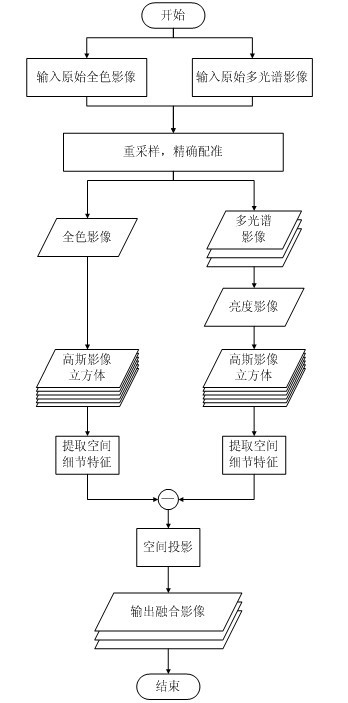
[0041] In order to better understand the technical solution of the present invention, the present invention will be further described in detail below in conjunction with the accompanying drawings. The embodiment of the present invention is to fuse the panchromatic image Pan and the multi-spectral image Mul, refer to figure 1 , the steps of the embodiment of the present invention are as follows:

[0042] Step a:

[0043]Image preprocessing is performed first. The image preprocessing in the embodiment includes resampling and precise registration (ie precise geometric correction processing in the art). The purpose of resampling is to make the original multispectral image have the same pixel size as the original panchromatic image, and the registration is to make the original multispectral image (that is, the original low spatial resolution multispectral image) High spatial resolution panchromatic images) are consistent in spatial location. According to the requirements of fus...


PUM


Abstract

The invention relates to a multi-scale spatial projecting and remote sensing image fusing method. The method comprises the following steps of: calculating the brightness image of a primary low-spatial resolution multispectral image by using the primary low-spatial resolution multispectral image, respectively generating the Gaussian image cube of the brightness image and a primary high-spatial resolution panchromatic image through improved Gaussian scale-space theory, extracting spatial detail characteristics of the brightness image and the panchromatic image through the difference between layers of the Gaussian image cube, and projecting the spatial detail characteristics onto the primary multispectral image according to a weighted fusion scheme to obtain a fused multispectral image with high spatial resolution and high spectral resolution. By the method, the spectral information of the primary multispectral image is well kept when the spatial detail performance ability of the fused image is improved; the physical significance is clear; the realization structure is simple; and the fusion effect is good.

Description

technical field [0001] The invention belongs to the technical field of remote sensing image processing data fusion and relates to a multi-scale spatial projection remote sensing image fusion method. Background technique [0002] The development of remote sensing technology provides a wealth of multi-source remote sensing data. These data from different sensors have different temporal, spatial and spectral resolutions as well as different polarization methods. The amount of image information acquired by a single sensor is limited, which is often difficult to meet the application needs. Through image fusion, more useful information can be obtained from different remote sensing images to supplement the deficiency of a single sensor. Image fusion refers to the process of generating new images from multi-source remote sensing images in a specified geographic coordinate system according to a certain algorithm. Panchromatic images generally have high spatial resolution, and multi...

Claims


Application Information

Patent Timeline
Patent Type & Authority Applications(China)
IPC IPC(8): G06T5/50G06T5/00
Inventor 邵振峰刘军
Owner WUHAN UNIV
Why Eureka
Try Eureka