Method for correcting navigation deviation and navigation display adopting same

A display and deviation technology, applied in directions such as road network navigators, can solve problems such as affecting the working accuracy of the inertial system, and achieve the effect of real-time error correction

Inactive Publication Date: 2011-08-10
BEIJING INSTITUTE OF TECHNOLOGYGY
View PDF0 Cites 36 Cited by
  • Summary
  • Abstract
  • Description
  • Claims
  • Application Information

AI Technical Summary

Problems solved by technology

[0004] Inertial navigation will inevitably produce gyro drift, and its random drift is accumulated over time, which affects the working accuracy of the inertial system

Method used


Image

  • Method for correcting navigation deviation and navigation display adopting same
  • Method for correcting navigation deviation and navigation display adopting same
  • Method for correcting navigation deviation and navigation display adopting same

Examples


Embodiment Construction

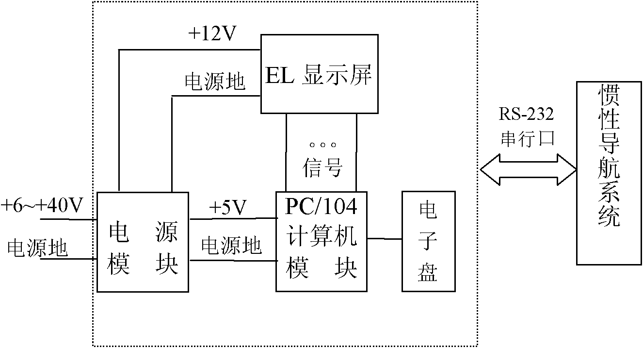
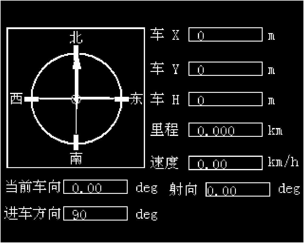
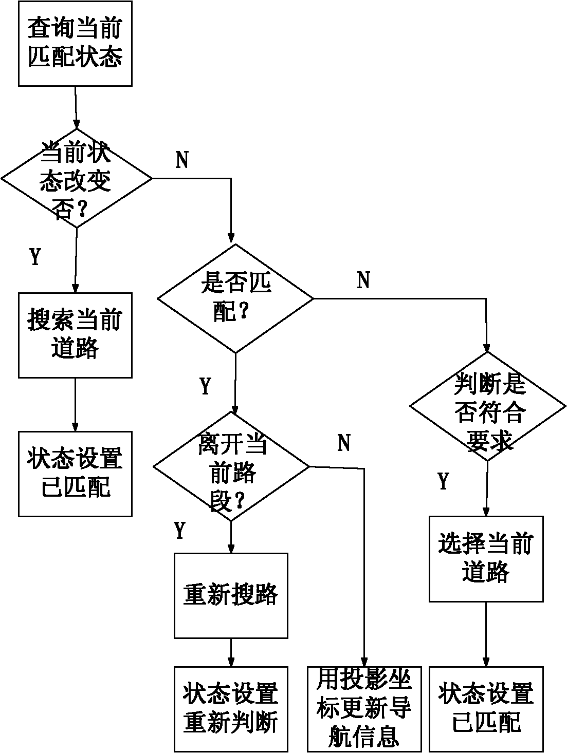
[0031] The north finder automatically completes the measurement of the north reference and the attitude angle of the carrier under the working condition of the carrier to provide the initial azimuth angle for the system; the azimuth maintainer completes the memory of the north azimuth reference and is sensitive to the change of the heading angle when the carrier is moving; the odometer The driving distance of the sensitive carrier provides mileage information for navigation calculation; the altimeter measures the elevation information of the carrier to enable the system to have a three-dimensional positioning function; the GPS / GLONASS receiver is used as an auxiliary component to provide reference position information for the system to improve the navigation of the system Positioning accuracy; heading indicator displays heading, mileage, position and other information for vehicle occupants; navigation control display completes system control management and realizes information e...


PUM


Abstract

The invention provides a method for correcting navigation deviation and a navigation display adopting the same. The method comprises the steps of: matching with a given electronic map through the moving and running directions of the coordinates of a vehicle, pointing out a currently selected road, obtaining matching degrees of candidate road sections by means of a matching degree function by taking the road section and the vehicle running direction as one parameter and taking an Euclidean distance from a measuring point to the candidate road section as the other parameter, and selecting the matching road section with the maximum matching degree. By means of the invention, the deviation of an inertial system, caused by gyro drift, can be eliminated, and errors can be corrected in real time to obtain the accurate running position and direction of the vehicle.

Description

technical field [0001] The invention relates to a display, which is mainly used for positioning and orientation in a land vehicle navigation system. In addition to the functions of displaying coordinates and azimuth and finding north, it also has a built-in electronic map, has a map matching function, and can effectively improve navigation accuracy. Background technique [0002] Due to the mobility, rapidity, and flexibility required by modern warfare, heavy weapons must be able to enter the position before they can be fired, and then they can be withdrawn; at the same time, for indirect aiming weapons, after entering the position, it is required to know its high-precision coordinates and orientation. In this way, an autonomous land vehicle navigation system that can quickly determine its own orientation and coordinates has extraordinary significance. The land vehicle navigation system is an autonomous inertial navigation system, which can independently determine its own pr...

Claims


Application Information

Patent Timeline
Patent Type & Authority Applications(China)
IPC IPC(8): G01C21/30G01C21/36
Inventor 韩勇强李磊磊陈家斌宋春雷谢玲
Owner BEIJING INSTITUTE OF TECHNOLOGYGY
Why Eureka
Try Eureka