
GIS (Geographic Information System) platform processing method for mass lightning data

A processing method and lightning technology, applied in the fields of electrical digital data processing, special data processing applications, instruments, etc., can solve problems such as difficulty in analysis and utilization, and large space for raw data data.

Inactive Publication Date: 2011-08-17
NANJING UNIV OF INFORMATION SCI & TECH
View PDF2 Cites 10 Cited by
  • Summary
  • Abstract
  • Description
  • Claims
  • Application Information

AI Technical Summary

Problems solved by technology

The number of daily lightning strikes ranges from a few to tens of thousands. Therefore, the original data stored in the form of text records takes up a huge space and is not easy to analyze and utilize.

Method used


Image

  • GIS (Geographic Information System) platform processing method for mass lightning data
  • GIS (Geographic Information System) platform processing method for mass lightning data
  • GIS (Geographic Information System) platform processing method for mass lightning data

Examples


Embodiment Construction

[0044] In order to make the purpose, technical solutions and advantages of the present invention clearer, the implementation of the present invention will be further described in detail below in conjunction with the accompanying drawings:

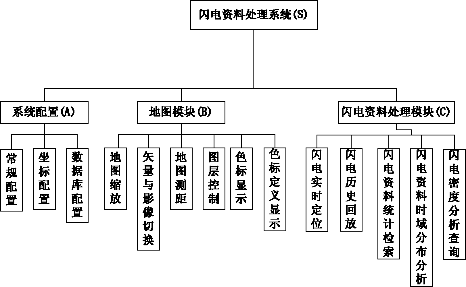
[0045]This example provides a GIS platform processing method for massive lightning data, combined with geographic information system (GIS) technology, researches data detection and real-time acquisition of lightning information, builds and maintains lightning database, and presents lightning distribution in real time in the form of spatial elements. Predict the development trend of lightning and provide necessary support for lightning protection decision-making. In addition to real-time monitoring, acquisition and display of lightning data, interactive statistics and analysis of historical lightning data, time evolution analysis and spatial density analysis of lightning on different time scales and different spatial scales are also used. Th...


PUM


Abstract

The invention discloses a GIS (Geographic Information System) platform processing method for mass lightning data, which comprises the following steps of: (1) establishing a lightning database to provide a basic data source for lightning analysis through inducing historical data and acquiring data in combination with a real-time lightning detection system, wherein lightning information is intuitively displayed by using a GIS platform for the convenience of predicting the development tendency of lightning; and (2) analyzing lightning data through an interactive method, and finally forming a weather product which can be issued, wherein the lightning data comprises the query and statistics of customized lightning information, lightning space density analysis and the like. As mass lightning data is processed on the GIS platform, the demand on lightning protection services is met. Real-time or delayed load, customized display as well as time domain and spatial analysis can be performed on a lot of lightning data, and therefore a technical support is provided for weather forecasters to observe and analyze lightning for the convenience of lightning prevention forecast in a better manner.

Description

technical field [0001] The invention belongs to the intersection field of lightning protection technology in GIS and meteorological information technology. Geographic Information System (GIS) is a spatial management system for the storage, display and related analysis of spatial information; it can conveniently split and store spatial data in the form of various attribute data, and display them in an intuitive and friendly way. Then perform various required spatial analysis, such as buffer analysis, etc.; in addition, it also supports various attribute queries and spatial relationship operations between graphics. Background technique [0002] The occurrence of lightning in nature is highly random, instantaneous and dangerous, and it is closely related to the strong convective system of the atmosphere. The lightning monitoring network is mainly composed of the ground atmospheric electric field monitoring network, lightning location monitoring network, and ground automatic ob...

Claims


Application Information

Patent Timeline
Patent Type & Authority Applications(China)
IPC IPC(8): G06F17/30
Inventor 毕硕本王启富朱斌侯荣涛冯民学史鑫明
Owner NANJING UNIV OF INFORMATION SCI & TECH
Learn More