Method for acquiring position information in real time based on GPS (Global Positioning System) data

A technology of GPS data and location information, applied in measuring devices, satellite radio beacon positioning systems, instruments, etc., can solve the problems of not being intuitive enough, occupying a large storage space, and affecting query speed, etc.

Inactive Publication Date: 2011-08-24
XIAMEN YAXON NETWORKS CO LTD
View PDF6 Cites 24 Cited by
  • Summary
  • Abstract
  • Description
  • Claims
  • Application Information

AI Technical Summary

Problems solved by technology

However, the description of place names in the existing position information description method is relatively simple. A village (town) only has the name of the village (town) without the name of the county (city) of the superior administrative region. For ordinary people, the effect of this description Not intuitive; however, if the description of the place name of each specific location object has the name of the superior administrative region, the amount of information repetition is too large, the storage space is large, and the query speed will also be affected

Method used


Image

  • Method for acquiring position information in real time based on GPS (Global Positioning System) data
  • Method for acquiring position information in real time based on GPS (Global Positioning System) data
  • Method for acquiring position information in real time based on GPS (Global Positioning System) data

Examples


Embodiment 1

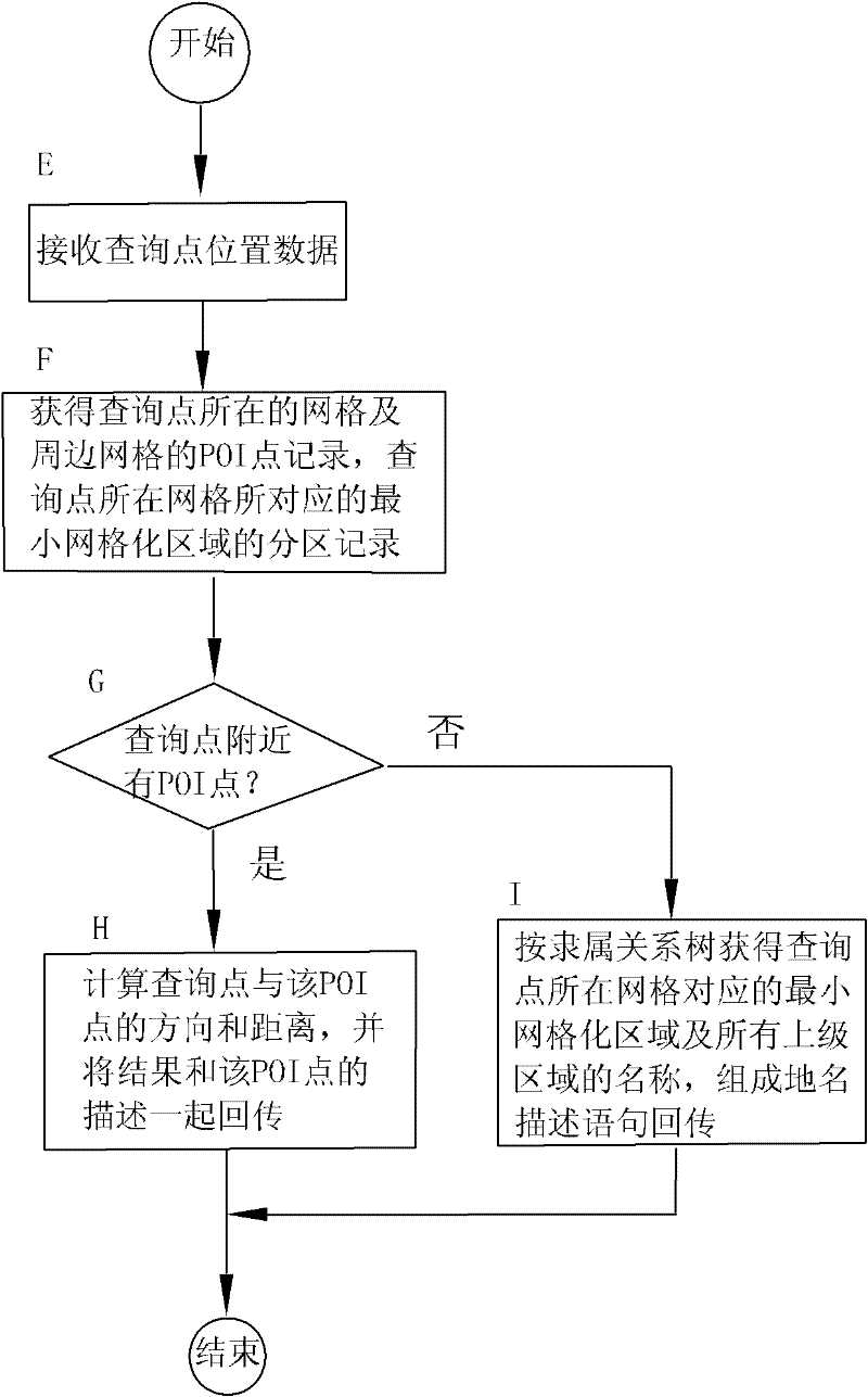
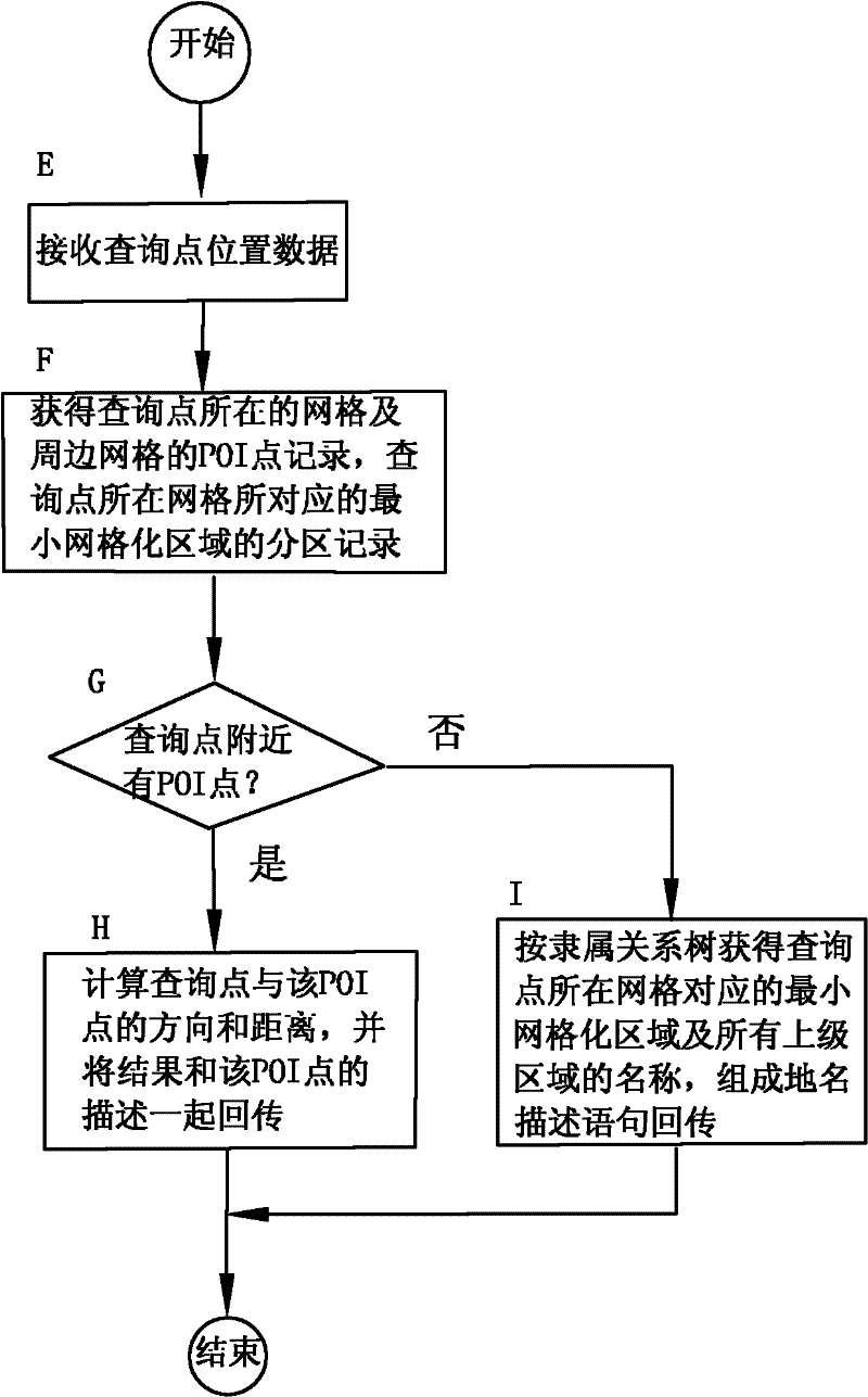
[0022] In one embodiment of the method for obtaining location information in real time based on GPS data in the present invention, the mobile terminal uploads the current GPS location data to the navigation center, and the navigation center replies with geographical description information of the location.

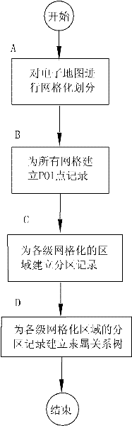
[0023] The process of map preprocessing in the navigation center, such as figure 1 Shown:

[0024] Step A, performing grid division on the electronic map provided by the map provider.

[0025] The electronic map provided by the map provider has clear hierarchical information, including national boundary layer, provincial boundary layer, city boundary layer, county boundary layer, town (township) boundary layer, village boundary layer, road layer and detailed POI points layers. The size of the grid division is predetermined, that is, the difference in longitude and latitude spanned by each grid. According to the principle of gridding, each surface mark, line mark, and po...


PUM


Abstract

The invention relates to a method for acquiring position information in real time based on GPS (Global Positioning System) data, relating to a method for intelligently navigating and positioning by a computer. In the method, a navigation center processing method comprises the following steps of: performing grid division to an electronic map; establishing POI (Point of Interest) point records for all grids; establishing sub-area records for various grid regions; establishing administering relation trees for sub-areas of various grid regions; receiving the position information of inquiring points; acquiring POI point records of the grid and peripheral grids where the inquiring points are, and the sub-area records of the minimal grid region corresponding to the grid where the inquiring points are; judging whether POI points are existed besides the inquiring points, if so, calculating the distance between the inquiring points and the POI point and re-transmitting the result and description of the POI point; if not, acquiring the minimal grid region corresponding to the grid of the inquiring points and the names of all dormant regions depending on the administering relation, thereby obtaining place name describing statement for re-transmission. The method in the invention is rapid in inquiring speed, and clear and direct in position information.

Description

technical field [0001] The invention relates to a computer intelligent navigation and positioning method. Background technique [0002] Since the GPS system was officially put into use in 1994, GPS applications around the world have entered a climax. Since GPS is a global, all-weather, continuous satellite radio navigation system, it can provide real-time three-dimensional coordinates, three-dimensional speed and high-precision time information. Because of its advantages of high positioning accuracy, fast speed, and wide range, it is used in almost all fields of the national economy. Its application fields include: military surveying and mapping, precision surveying, geographical science research, precision agriculture, navigation positioning and traffic management. Especially the application of navigation positioning is more popular. [0003] Since GPS provides geodetic coordinates in latitude and longitude format, navigation requires plane coordinates and their relative...

Claims


Application Information

Patent Timeline
Patent Type & Authority Applications(China)
IPC IPC(8): G01S19/42G01C21/32
Inventor 余建成韩震华傅建记洪志新张华
Owner XIAMEN YAXON NETWORKS CO LTD
Why Eureka
Try Eureka