Personalized and context-sensitive 3D route guidance

A route and road section technology, applied in the field of images presenting electronic navigation maps, can solve the problems of no enlightenment, visual confusion, and inability to provide clear route guidance for drivers, so as to reduce cognitive load, improve visual clarity, improve The effect of experience

Active Publication Date: 2011-09-14
ROBERT BOSCH GMBH
View PDF6 Cites 1 Cited by
  • Summary
  • Abstract
  • Description
  • Claims
  • Application Information

AI Technical Summary

Problems solved by technology

However, apparently in figure 2 In , this approach can lead to visual confusion for the observer in understanding what is a route, what is a building, and where the route and buildings relate to each other
Also, this method of building transparency may not provide clear route guidance to drivers
[0005] There is neither disclosure nor suggestion in the prior art to provide a method for presenting 3D landmarks and other 3D objects on a navigation map that overcomes the above-mentioned problems and drawbacks

Method used


Image

  • Personalized and context-sensitive 3D route guidance
  • Personalized and context-sensitive 3D route guidance
  • Personalized and context-sensitive 3D route guidance

Examples


Embodiment Construction

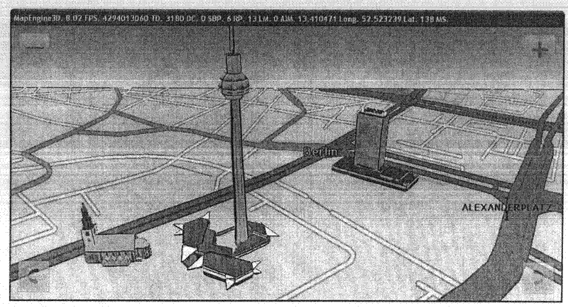
[0027] The present invention provides a method of 3D navigation using an NPR 3D map, which includes stylized visualization of 3D objects in the navigation map. The 3D objects displayed in the 3D navigation map include buildings, landmarks, POIs, hazardous locations, and roads. Generate NPR 3D maps based on 3D object data generated in different ways. This 3D data is provided by the data provider in a format suitable only for photorealistic rendering (eg polygon faces with photorealistic textures). In this case, these data were enhanced for NPR presentation.

[0028] To avoid the occlusion problem, the present invention describes the 3D objects along the route in a context-sensitive manner, which provides the user with a higher level of navigation relative to the position of the 3D objects along the route. The visualization style of these 3D objects (eg, buildings or landmarks) along the route can be changed to highlight the route, or to visualize the route to a higher degree....


PUM


Abstract

The invention relates to a personalized and context-sensitive 3D route guidance. A method of displaying a navigation map includes determining a route of a vehicle. Three-dimensional data is received. The data is associated with buildings that are disposed within a geographic area. The geographic area includes the route of the vehicle. At least one of the buildings in the data that is adjacent to at least one street of the route is rendered in a first opaque visual style. All of the buildings in the data that are nonadjacent to at least one street of the route are rendered in at least one second visual style different from the first opaque visual style.

Description

technical field [0001] The present invention relates to electronic navigation maps, and more particularly to presenting images of electronic navigation maps. Background technique [0002] Navigation maps are an important resource for visitors to unfamiliar cities because they visually highlight landmarks including buildings, natural features, and points of interest such as museums, restaurants, parks, and shopping areas. While most in-vehicle or portable navigation devices (PNDs) rely on two-dimensional navigation maps to visualize these landmarks in two dimensions, three-dimensional in-vehicle navigation systems are emerging. [0003] Navigating with a 3D map has many advantages. For example, 3D maps can provide better driver orientation than 2D maps because people live in a 3D world. 3D maps can also improve landmark recognition, because important features (e.g. geometry, buildings, textures) of 3D buildings / landmarks can be fully disclosed, so it is easy for the user to...

Claims


Application Information

Patent Timeline
Patent Type & Authority Applications(China)
IPC IPC(8): G01C21/36
CPCG01C21/3638
Inventor 任骝翁富良
Owner ROBERT BOSCH GMBH
Why Eureka
Try Eureka