Geographic information system (GIS) and geographic position calibrating and querying method thereof

A technology of geographic location and query method, which is applied in the field of GIS system and its geographic location calibration and query, which can solve problems such as house numbers not conforming to definition rules, and achieve the effect of convenient manual input, convenient query, and simple coding

Inactive Publication Date: 2011-11-23
PEKING UNIV SHENZHEN GRADUATE SCHOOL
View PDF2 Cites 4 Cited by
  • Summary
  • Abstract
  • Description
  • Claims
  • Application Information

AI Technical Summary

Problems solved by technology

Another method is to create your own code. In the creation process, some methods directly use the house number as part of the data to calibrate the location of the building. Although the house number in my country gradually increases from east to west and from south to north, odd and even numbers are used. Distinguish the numbering rules on both sides of the street, but because some house numbers do not actually conform to their definition rules, if we copy and enter the location of the real estate relative to the street, it will become dirty data

Method used


Image

  • Geographic information system (GIS) and geographic position calibrating and querying method thereof
  • Geographic information system (GIS) and geographic position calibrating and querying method thereof
  • Geographic information system (GIS) and geographic position calibrating and querying method thereof

Examples


Embodiment Construction

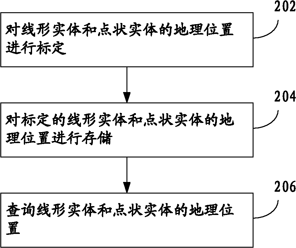
[0029] The present invention will be further described in detail below through specific embodiments in conjunction with the accompanying drawings.

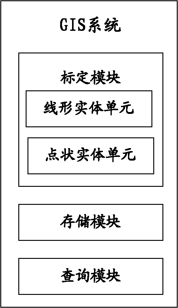
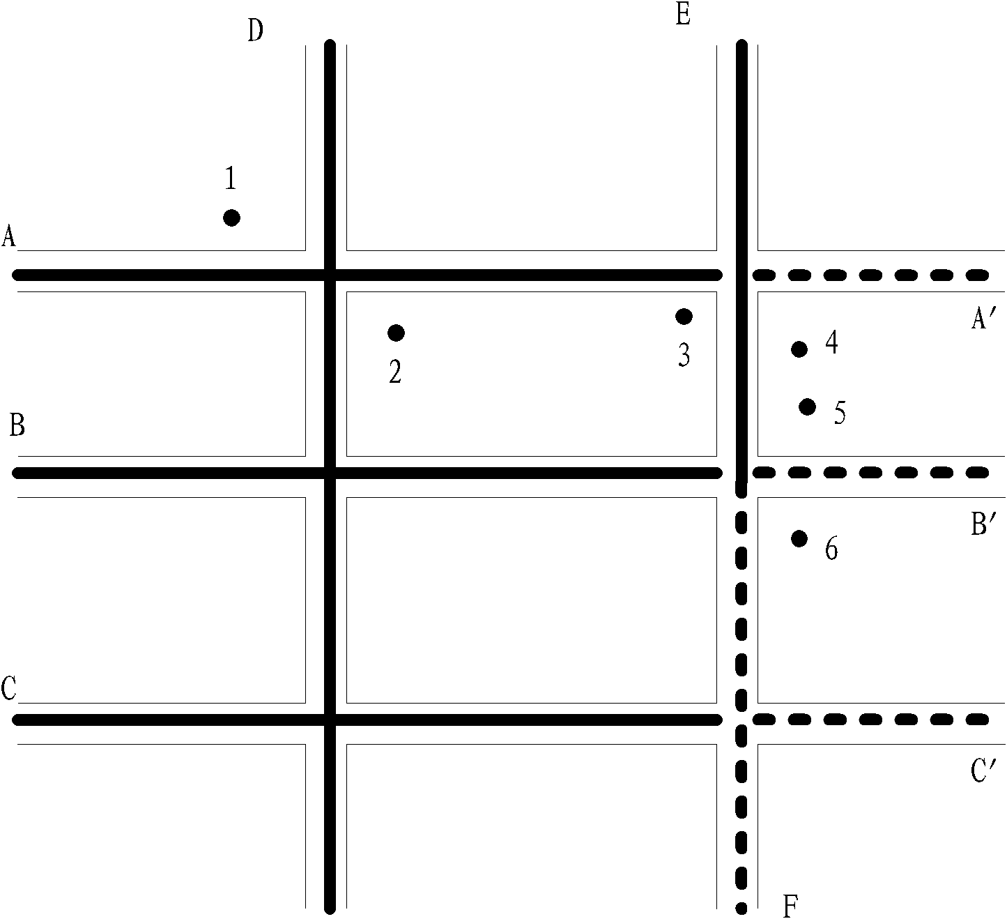
[0030] The linear entities involved in the present invention refer to but are not limited to roads, rivers, pipelines, etc. that are linear entities in the GIS system, and the point entities refer to but are not limited to buildings, communities, parks, etc. that are point-shaped in the GIS system. a class of entities. The horizontal reference position in the present invention refers to the relative position of the geographical entity (including the above-mentioned linear entity and point entity) in the east-west direction, and the vertical reference position refers to the relative position of the geographical entity in the north-south direction.

[0031] The core of the present invention is to adopt a geographical location calibration method oriented to geographic entities, which belongs to the calibration method of data models o...


PUM


Abstract

The invention discloses a geographic position calibrating and querying method for a geographic information system (GIS). The method comprises the following steps of: calibrating geographic positions of a linear entity and a point entity; storing the positions of calibrated geographic entities such as the linear entity and the point entity; and querying the positions of the linear entity and the point entity, wherein the geographic position of the calibrated linear entity comprises the orientation and the relative position of the linear entity; and the geographic position of the calibrated point entity comprises the geographic position of a linear entity which is closest to the point entity, and the relative position of the point entity. The invention further discloses the geographic information system (GIS). In the method, the geographic position is calibrated according to the relative position relationship between the point entity and the linear entity, and the method does not depend on the conventional GIS; manual input is convenient to realize; and the method has high expandability and reliability.

Description

technical field [0001] The invention relates to a GIS system and its geographical position marking and querying method. Background technique [0002] GIS (Geographic Information System: Geographic Information System) is a computer system that deals with the input, output, management, query, analysis and decision-making of geographic data. The basic technologies are database, map visualization and spatial analysis. [0003] As far as GIS conceptual data models are concerned, there are currently two main categories: topological relational data models and entity-oriented data models, among which topological relational data models are commonly used in early GIS application systems. These two models have their advantages in the scalability of storage structure, the expressibility of complex geographical entities, the efficiency of single entity query and topology query. [0004] The topological relationship data model organizes and stores various geometric elements based on the ...

Claims


Application Information

Patent Timeline
Patent Type & Authority Applications(China)
IPC IPC(8): G06F17/30G01C21/26
Inventor 徐伯星于雅洁杭诚方卢佳丛鹏飞
Owner PEKING UNIV SHENZHEN GRADUATE SCHOOL
Why Eureka
Try Eureka