Method for eliminating terrestrial clutters of airborne weather radar based on terrain altitude data

An airborne weather radar, terrain elevation technology, applied in the direction of climate sustainability, radio wave measurement system, radio wave reflection/reradiation, etc., can solve problems such as the influence of clutter position calculation

Active Publication Date: 2013-03-06
CIVIL AVIATION UNIV OF CHINA
View PDF3 Cites 0 Cited by
  • Summary
  • Abstract
  • Description
  • Claims
  • Application Information

AI Technical Summary

Problems solved by technology

Among them, the determination of the depression angle range of the beam is very important. Once there is an error in the depression angle, it will have a very large impact on the calculation of the subsequent clutter position.

Method used


Image

  • Method for eliminating terrestrial clutters of airborne weather radar based on terrain altitude data
  • Method for eliminating terrestrial clutters of airborne weather radar based on terrain altitude data
  • Method for eliminating terrestrial clutters of airborne weather radar based on terrain altitude data

Examples


Embodiment Construction

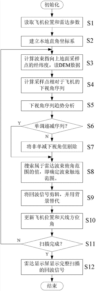
[0044] Hereinafter, the ground clutter removal method of airborne weather radar based on terrain elevation data provided by the present invention will be described in detail with reference to the accompanying drawings and specific embodiments.

[0045] figure 1 The flow chart of the airborne weather radar ground clutter removal method based on terrain elevation data provided by the present invention. All the operations shown are completed in the airborne electronic equipment with the computer as the core, so the main body of the operation is the computer .

[0046] Such as figure 1 As shown, the airborne weather radar ground clutter removal method based on terrain elevation data provided by the present invention includes the following steps in sequence:

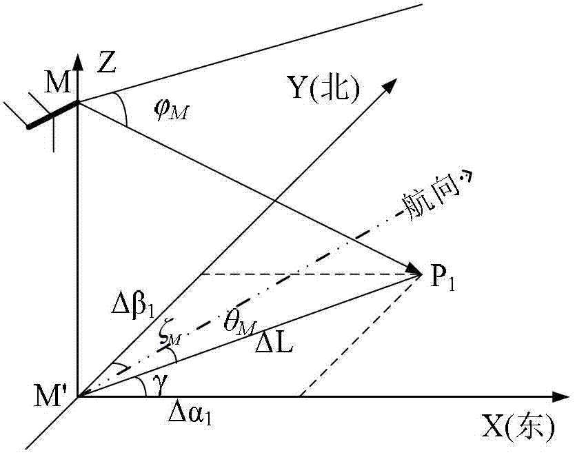
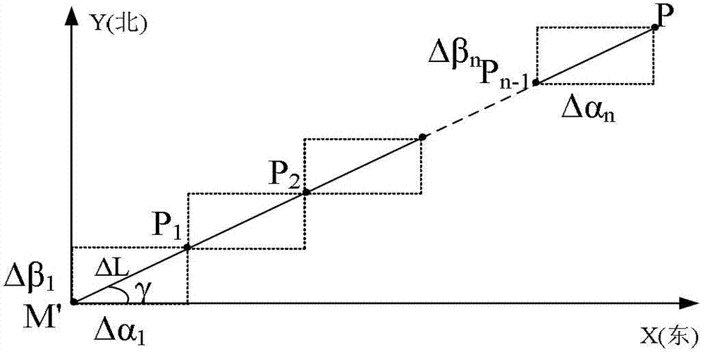
[0047] 1) The S1 stage of reading the aircraft position and radar parameters: read the aircraft geographical position and radar parameters from the airborne radar electronic equipment: the latitude and longitude of the aircraft (α...


PUM


Abstract

The invention provides a method for eliminating terrestrial clutters of an airborne weather radar based on terrain altitude data. The method provided by the invention comprises the following steps of: reading airplane position and radar parameters, establishing a local rectangular coordinate system, calculating longitudes and latitudes of ground sampling points in a beam direction, reading DEM (Digital Elevation Model) data, calculating a lower view angle sequence of the sampling points relative to an airplane, analyzing a tendency of the lower view angle sequence, judging a monotonically decreasing sequence, eliminating a non-monotonically-decreasing lower view angle value, determining a beam grounding range, editing echo signals and replacing by a background, updating the airplane position and an antenna azimuth angle, judging whether the scanning is finished, displaying complete scanning echo signals by a radar display screen and the like. According to the method provided by the invention, by utilizing the characteristics that the terrestrial clutters of the airborne weather radar echoes and weather targets are respectively located at units with different distances and can be separated in the distance and adopting the discipline characteristics of the lower view angle, the grounding position of the radar beam is analyzed, and the terrestrial clutters is eliminated by utilizing and utilizes the terrain altitude data; and the method has the advantages of simple method, calculation accuracy, good inhibition effect, capability of effectively eliminating terrestrial cluttersof the airborne weather radar in a time domain and the like.

Description

Technical field [0001] The invention belongs to the technical field of airborne radar ground clutter suppression, and particularly relates to an airborne weather radar ground clutter elimination method based on terrain elevation data. Background technique [0002] Because the airborne weather radar is installed on the aircraft, it is generally in the downward-looking working mode when working, so it faces more serious ground (sea) clutter than the ground-based weather radar, and the clutter has a wide distribution range and high intensity. In addition, the frequency shift of the main lobe clutter caused by the movement of the carrier and the increase in the scanning azimuth angle also broaden the clutter frequency band. This kind of clutter Doppler broadening makes the conventional frequency domain filtering method invalid and cannot separate it from the frequency domain. But at this time, clutter and meteorological targets are usually separable in space. [0003] At present, gro...

Claims


Application Information

Patent Timeline
Patent Type & Authority Patents(China)
IPC IPC(8): G01S7/36G01S13/95
CPCY02A90/10
Inventor 吴仁彪秦娟苏志刚卢晓光
Owner CIVIL AVIATION UNIV OF CHINA
Why Eureka
Try Eureka