Digital Array Meter Wave Radar Super-resolution Altimetry Method Based on Terrain Matching

A meter-wave radar and digital array technology, applied in the field of meter-wave radar altimetry and super-resolution altimetry based on terrain matching, can solve the problems of difficult to detect low-altitude targets, large angle measurement errors, and large fluctuations in launching points, and achieve improved The effect of position adaptability, reducing the amount of algorithm calculation, and improving the accuracy of angle measurement

Active Publication Date: 2011-12-21
XIDIAN UNIV
View PDF2 Cites 35 Cited by
  • Summary
  • Abstract
  • Description
  • Claims
  • Application Information

AI Technical Summary

Problems solved by technology

However, meter wave radar is limited by factors such as long wavelength, limited antenna size and height, wide antenna beam width, low angular resolution, and more importantly, it is difficult to detect due to the so-called "multipath" problem caused by ground and sea reflections. Low-altitude targets, and it is difficult to measure height in a multi-path environment, so the height measurement problem of meter wave radar ha...

Method used


Image

  • Digital Array Meter Wave Radar Super-resolution Altimetry Method Based on Terrain Matching
  • Digital Array Meter Wave Radar Super-resolution Altimetry Method Based on Terrain Matching
  • Digital Array Meter Wave Radar Super-resolution Altimetry Method Based on Terrain Matching

Examples


Embodiment Construction

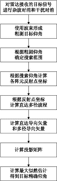
[0044] The content and effects of the present invention will be described in detail below in conjunction with the accompanying drawings.

[0045] refer to figure 1 , the present invention comprises the following steps:

[0046] Step 1: Perform clutter cancellation and interference cancellation processing on the target signal received by the radar to obtain the target signal after cancellation.

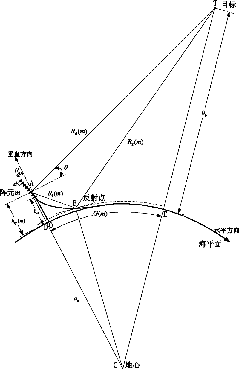
[0047] The model of radar receiving target signal among the present invention is as figure 2 shown. figure 2 A far-field narrowband signal is incident on a uniform linear array composed of M array elements, and the tilt angle of the antenna is θ a , the elevation is h a0, the array element interval is d, the projection point of the first antenna on the sea level is taken as the coordinate origin, point D is the ground projection point of the mth array element, point E is the ground projection point of the target, a e is the equivalent earth radius, R t is the target distance, θ...


PUM


Abstract

The invention discloses a super-resolution height measuring method based on topographic matching for a digital array meter wave radar, which is mainly used for solving the problem of high height measuring error of a fluctuating position in the prior art. The method comprises the following implementation steps of: performing clutter cancellation and interference cancellation processing on a targetsignal received by the radar to obtain a cancelled target signal; roughly measuring a target elevation angle by using a beam forming method; determining a maximum likelihood search range according tothe roughly-measured elevation angle and searching in the search range; computing a ground reflection point coordinate corresponding to each array element and a direct wave path and a reflection wavepath of each target relative to each array element according to a search elevation angle; computing a corresponding direct steering vector and a multipath steering vector by using the direct wave path and the reflection wave path; constructing a synthetic steering vector and computing a projection matrix of the synthetic steering vector; and performing maximum likelihood estimation to obtain a target accurate elevation angle. In the method, an altitude parameter of a radar position and the synthetic steering vector are introduced into super-resolution height measurement, so that the measuringaccuracy is increased; and the method can be applied to target tracking.

Description

technical field [0001] The invention belongs to the technical field of radar signal processing, and relates to meter-wave radar height measurement. Specifically, it proposes a terrain-matching-based super-resolution height measurement method for digital array meter-wave radar, which can be used for target tracking. Background technique [0002] According to the elevation angle beam forming method and scanning method, three-coordinate 3D radar can be divided into stacked beam radar, frequency scanning radar, phase scanning radar and digital beam forming radar. [0003] The stacked beam radar stacks the received beams formed at the same time vertically in elevation and scans mechanically in azimuth to realize the measurement of the search target and the three coordinates of the target. For example, the land-based S-band three-coordinate AN / TPS-43 radar in the United States covers an elevation range of 20° with six elevation beams. The L-band three-coordinate S713Martello rada...

Claims


Application Information

Patent Timeline
IPC IPC(8): G01S7/40G01S13/68
Inventor 朱伟陈伯孝杨明磊
Owner XIDIAN UNIV
Why Eureka
Try Eureka