Watershed scale soil moisture remote sensing data assimilation method

A technology of soil moisture and remote sensing data, applied in electrical digital data processing, special data processing applications, instruments, etc.

Inactive Publication Date: 2012-02-15
NANJING UNIV
View PDF0 Cites 40 Cited by
  • Summary
  • Abstract
  • Description
  • Claims
  • Application Information

AI Technical Summary

Problems solved by technology

The observation of soil moisture by microwave remote sensing also has certain limitations. Due to the influence of vegetation and the limitation of microwave wavelength, the soil moisture that can be detected by spaceborne microwave remote sensing is only the moisture content of the ground surface (only a few centimeters).

Method used


Image

  • Watershed scale soil moisture remote sensing data assimilation method
  • Watershed scale soil moisture remote sensing data assimilation method
  • Watershed scale soil moisture remote sensing data assimilation method

Examples


Embodiment

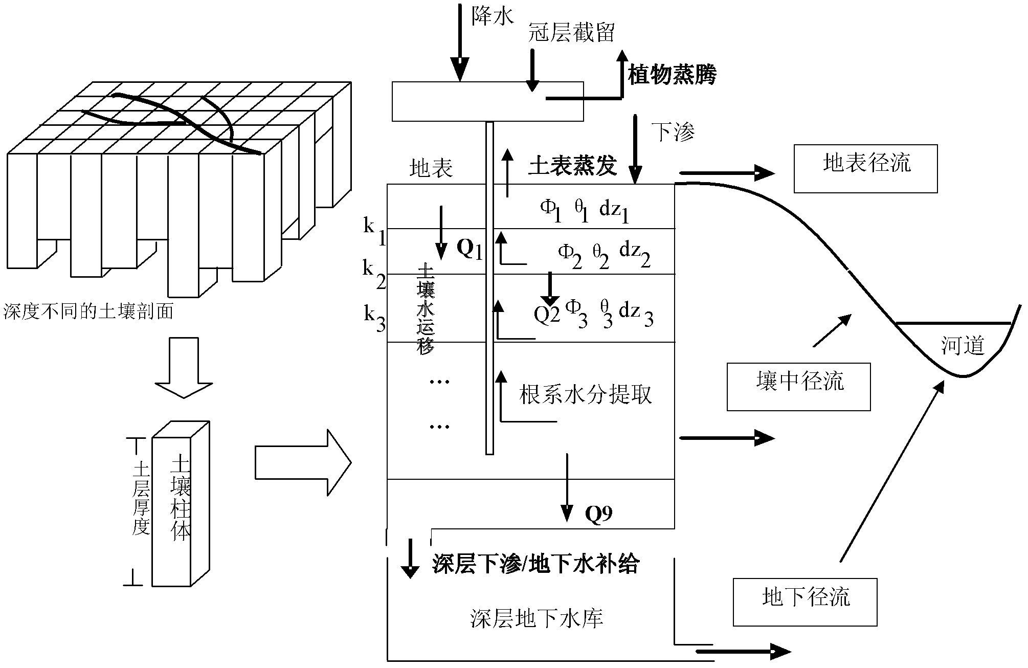
[0178] 1. Overview of the study area

[0179] The Yihe River Basin is located in the south of Shandong Province in North China. Its catchment area is 2413km2. The annual average precipitation in the basin is 830mm, and the rainfall in the flood season is 616mm, accounting for about 75% of the annual precipitation. It belongs to the semi-humid and semi-arid area.

[0180] 2. Basic data of the study area

[0181] A. Hydrological and Meteorological Data

[0182] The daily precipitation observation and water surface evaporation observation data of 10 meteorological stations in the Yihe River Basin from 2001 to 2003, 2006 and 2007 were collected, and the basin flow verification station was Linyi Hydrological Station.

[0183] B. DEM data

[0184] The digital elevation required for simulation and assimilation research was collected and sorted out: 90m resolution DEM provided by SRTM project, sampled to 1000m and 240m spatial resolution respectively, using UTM projection, WGS84 coo...


PUM


Abstract

The invention discloses a watershed scale soil moisture remote sensing data assimilation method belonging to the field of remote sensing data assimilation methods. The method comprises the following steps of: (A) preparing for data; (B) constructing a watershed soil moisture assimilation observation operator; (C) constructing a distributed hydrologic model assimilation platform; and (D) constructing a watershed soil moisture remote sensing data assimilation scheme based on a distributed hydrologic model and particle filter assimilation algorithm. In the invention, a novel distributed watershed hydrologic model which is capable of effectively fusing microwave remote sensing information and has a certain physical basis is constructed by utilizing soil water hydrodynamic method and combining a saturation excess runoff principle, a hydrological simulation detection result of the Yi River watershed in a typical semi-arid and semi-humid area shows that the novel distributed watershed hydrologic model has a better daily runoff simulation effect and stable surface soil moisture simulation precision and can be used as a watershed soil moisture remote sensing data assimilation model operator. By using the watershed scale soil moisture remote sensing data assimilation method, a watershed scale soil moisture assimilation data set in temporal and spatial distribution can be acquired effectively.

Description

technical field [0001] The invention relates to a method for assimilating remote sensing data, more specifically, the inversion information of surface soil moisture in a watershed obtained by remote sensing and a specific data assimilating method. Background technique [0002] The study of watershed-scale and field-scale soil moisture status is conducive to deepening people's understanding of hydrological processes and helping to finally grasp the complex interactions between surface water and groundwater resources. In the field of hydrology and water resources, the accurate spatial distribution of soil moisture can be used as the initial value of the soil moisture variable required for the flood simulation of the distributed hydrological model to improve the accuracy of flood forecasting; in addition, the corrected continuous and accurate soil moisture Substituting data into hydrological models has potential value in improving the accuracy of long-term hydrological process ...

Claims


Application Information

Patent Timeline
Patent Type & Authority Applications(China)
IPC IPC(8): G06F19/00
Inventor 张万昌陈炯峰
Owner NANJING UNIV
Why Eureka
Try Eureka