Path planning method and device

A path planning and planning technology, applied in the field of intelligent transportation, can solve problems such as slow driving, inconvenient travel for users, waste of time, etc., and achieve the effect of saving time

Inactive Publication Date: 2012-03-28
CENNAVI TECH
View PDF2 Cites 64 Cited by
  • Summary
  • Abstract
  • Description
  • Claims
  • Application Information

AI Technical Summary

Problems solved by technology

[0004] When abnormal conditions (such as traffic jams, road construction, or traffic accidents, etc.) occur in a section of the road determined by the navigation system, causing vehicl

Method used


Image

  • Path planning method and device
  • Path planning method and device
  • Path planning method and device

Examples


Embodiment 1

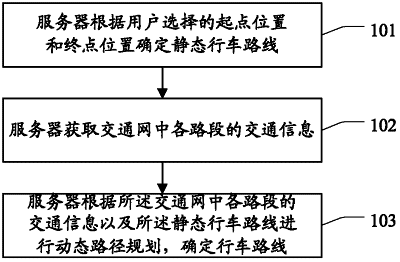
[0022] The embodiment of the present invention provides a path planning method, such as figure 1 As shown, the method includes:

[0023] 101. The server determines a static driving route according to the starting point and the ending point selected by the user, and the static driving route includes at least one driving route from the starting point to the ending point.

[0024] Specifically, the server may determine the static driving route from the start point to the end point through the GIS electronic map, but it is not limited thereto. Wherein, the static driving route is generally a route with a relatively short distance from the starting point to the ending point, and there may be one or multiple routes, which are not limited here.

[0025] 102. The server acquires traffic information of each road segment in the traffic network, where the traffic information of the road segment includes traffic condition information of the road segment and / or event information occurring...

Embodiment 2

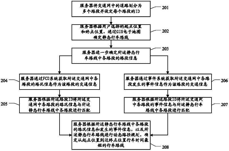
[0030] The embodiment of the present invention provides a path planning method, such as figure 2 As shown, the method includes:

[0031] 201. The server divides the roads in the traffic network into multiple road sections and sets the ID of each road section, wherein the traffic network can be determined according to user instructions, or can be automatically matched by the server according to the user's location The traffic network of the city where the user resides, but not limited thereto; the link ID is the identification of the link.

[0032] Specifically, the server may use but not limited to the following methods to divide road sections:

[0033] divide the area between two intersections in a road into a road segment; or

[0034] Divide the area between two overpasses on an urban ring road or an inner-urban expressway into one road segment; or

[0035] Divides the area between two exits or entrances of a highway into a road segment.

[0036] 202. The server determi...

Embodiment 3

[0052] The embodiment of the present invention provides a device for path planning, which can realize the above method embodiment, such as image 3 Said, said device comprises:

[0053] A determining unit 31, configured to determine a static driving route according to the starting position and the ending position selected by the user, the static driving route including at least one driving route from the starting position to the ending position;

[0054] An acquisition unit 32, configured to acquire traffic information of each road segment in the traffic network, where the traffic information of the road segment includes road condition information of the road segment and / or event information occurring on the road segment;

[0055] The route planning unit 33 is configured to perform dynamic route planning according to the traffic information of each road segment in the traffic network and the static route to determine the route.

[0056] Further, such as Figure 4 As shown, t...


PUM


Abstract

The invention discloses a path planning method and device, and relates to the field of intelligent transportation, and the method and device provided by the invention are used for solving the problem that a great amount of time is wasted in the driving process for users when abnormal conditions occur in the driving path determined by a navigation system in the prior art. The method provided by the invention comprises the following steps: determining the static driving path according to the initial position and the final position selected by users, wherein the static driving path comprises at least one driving path from the initial position to the final position; acquiring the transporation information of each road section in a transportation network, wherein the transportation information of the road section comprises the road condition information of the road section and/or the event information occurs for the road section; and carrying out dynamic path planning according to the transportation information of each road section in the transportation network and the static driving path, and determining the driving path. The method and device provided by the invention are suitable for the field of intelligent transportation, and are used for path planning.

Description

technical field [0001] The invention relates to the field of intelligent transportation, in particular to a path planning method and device. Background technique [0002] With the popularity of automobiles and the construction of roads, people are often not limited to activities in the area around them. When people go out by car, the situation that they don't know the road and can't find the destination also happens frequently. Currently, a navigation mode based on a GIS (Geographic Information System, Geographic Information System) electronic map combined with a GPS system (Global Positioning System, Global Positioning System) has become a popular trend in personal route planning. The current navigation mode is mainly to determine the driving route through the electronic map based on GIS, and to determine the location of oneself through the GPS system for route planning. Specifically, in the existing navigation mode, one or several paths with relatively short distances fr...

Claims


Application Information

Patent Timeline
IPC IPC(8): G01C21/34
Inventor 常思阳蒋晟
Owner CENNAVI TECH
Why Eureka
Try Eureka