Method and system for generating earth surface albedo product

A technology of surface albedo and surface reflectance, which is applied in the field of satellite remote sensing, can solve problems such as the inability to meet the needs of long-term sequence, high temporal and spatial resolution, and high-quality remote sensing production

Inactive Publication Date: 2012-05-02
BEIJING NORMAL UNIVERSITY
View PDF6 Cites 25 Cited by
  • Summary
  • Abstract
  • Description
  • Claims
  • Application Information

AI Technical Summary

Problems solved by technology

The production of remote sensing products in China uses personal computers to produce small batches of products, which cannot meet the needs of long-term sequence, high temporal and spatial resolution, and high-quality remote sensing production

Method used


Image

  • Method and system for generating earth surface albedo product
  • Method and system for generating earth surface albedo product
  • Method and system for generating earth surface albedo product

Examples


Embodiment Construction

[0055] The specific implementation manners of the present invention will be further described in detail below in conjunction with the accompanying drawings and embodiments. The following examples are used to illustrate the present invention, but are not intended to limit the scope of the present invention.

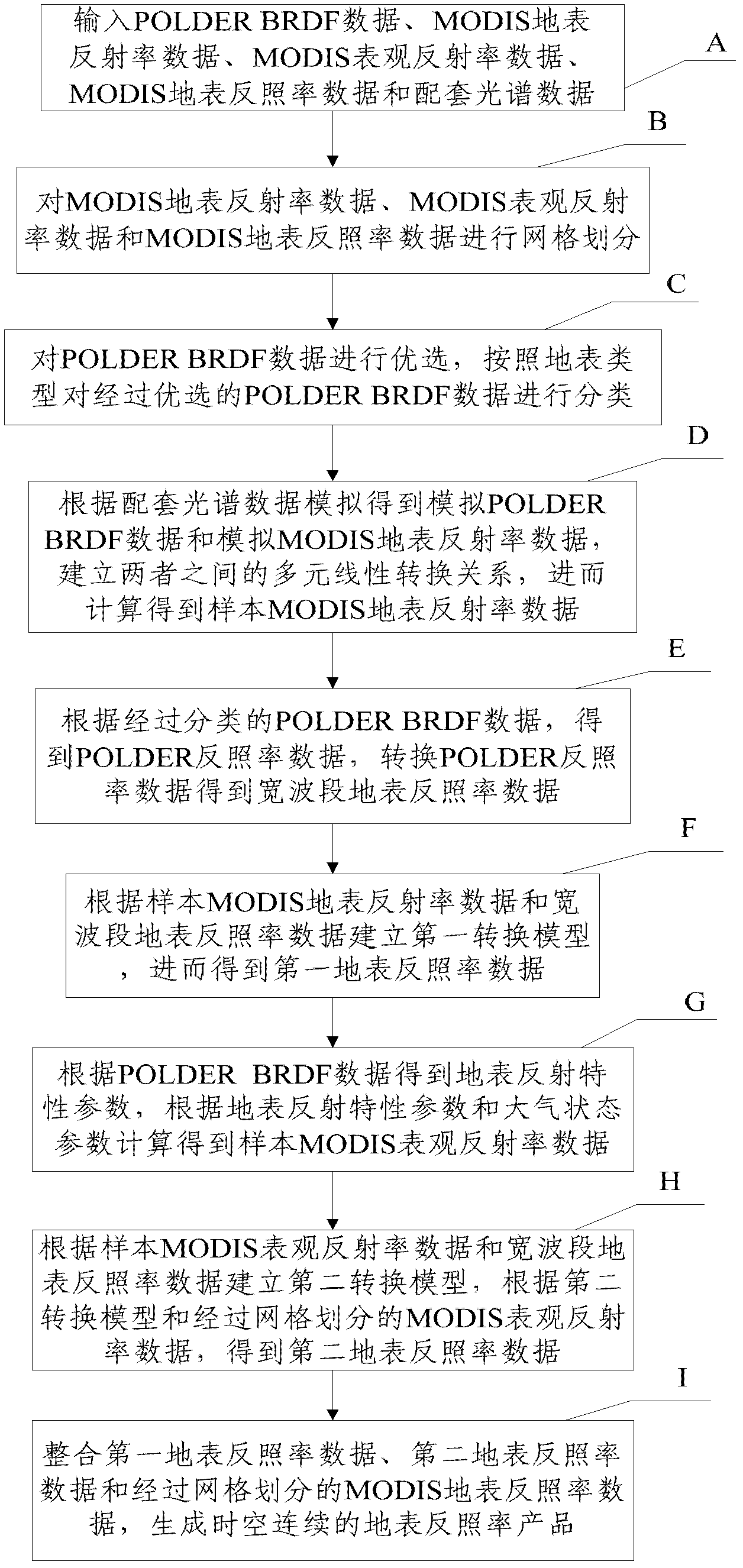
[0056] figure 1 It is a flow chart of the method for generating the surface albedo product described in the embodiment of the present invention. Such as figure 1 As shown, the method includes:

[0057] Step A: Enter the following data:

[0058] (1) POLDER BRDF data

[0059] The spatial resolution of POLDER BRDF data is (6km×7km), which is the latest multi-angle satellite remote sensing data available at present, with rich angle, spectrum and polarization information, and is one of the ideal data for multi-angle remote sensing. The input POLDER BRDF data includes a total of 13227 data files.

[0060] (2) MODIS surface reflectance data

[0061] MODIS surface albedo da...


PUM


Abstract

The invention discloses a method and system for generating an earth surface albedo product, which relate to the satellite remote sensing field. The method comprises the following steps of: according to classified POLDER BRDF data, obtaining POLDER albedo data and converting the POLDER albedo data to obtain wide waveband earth surface albedo data; according to sample MODIS earth surface albedo data and the wide waveband earth surface albedo data, building a first conversion model to obtain first earth surface albedo data; according to sample MODIS surface appearance albedo data and the wide waveband earth surface albedo data, building a second conversion model to obtain second earth surface albedo data; and integrating the first and second earth surface albedo data and the MODIS earth surface albedo data divided by grids to generate the earth surface albedo product with space-time continuum. According to the invention, the earth surface albedo product with long-time sequence, space-time continuum and high space-time resolution is generated and the inversion accuracy of the earth surface albedo product is improved.

Description

technical field [0001] The invention relates to the technical field of satellite remote sensing, in particular to a method and system for generating surface albedo products. Background technique [0002] Surface albedo reflects the ability of the earth's surface to reflect solar radiation, and is one of the driving factors in the energy balance of surface radiation and the interaction between the earth and the atmosphere. Its temporal and spatial changes are affected by natural processes and human activities, and it is an indicator of global environmental changes. factor. [0003] At present, some satellite albedo products have been commercially operated and released, with spatial resolutions ranging from 250m-20km and time resolutions ranging from day to month. Polar orbit satellite products include MODIS, MISR, CERES, POLDER, and MERIS. Geosynchronous satellite products include Meteosat, and MSG. [0004] At present, a large number of surface albedo inversion studies hav...

Claims


Application Information

Patent Timeline
Patent Type & Authority Applications(China)
IPC IPC(8): G01N21/55G01S7/48G06F19/00
Inventor 赵祥刘强王立钊张鑫瞿瑛梁顺林
Owner BEIJING NORMAL UNIVERSITY
Why Eureka
Try Eureka