Flight planning method for airborne synthetic aperture radar

Active Publication Date: 2012-05-16
关鸿亮
View PDF4 Cites 22 Cited by
  • Summary
  • Abstract
  • Description
  • Claims
  • Application Information

AI Technical Summary

Problems solved by technology

Therefore, the ordinary optical route design method cannot minimize the image distortion caused by the imaging characteristics of the airborne synthetic aperture radar image itself
[0009] At present, there is no precedent for large-scale application of airborne synthetic aperture radar technology in the field of mapping at home and abroad. Therefore, airborne synthetic aperture radar route planning technology is still immature and needs further research

Method used


Image

  • Flight planning method for airborne synthetic aperture radar
  • Flight planning method for airborne synthetic aperture radar

Examples


Embodiment Construction

[0028] The technical solutions of the present invention will be further described below in conjunction with the accompanying drawings and through specific implementation methods.

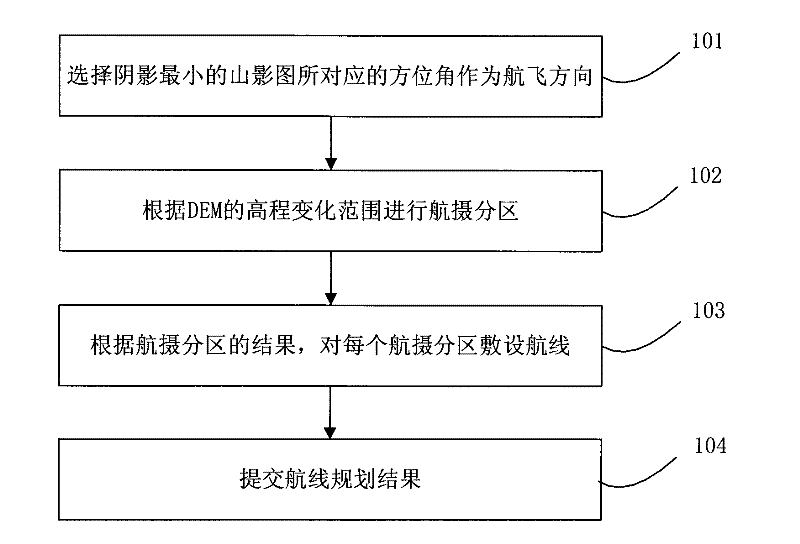
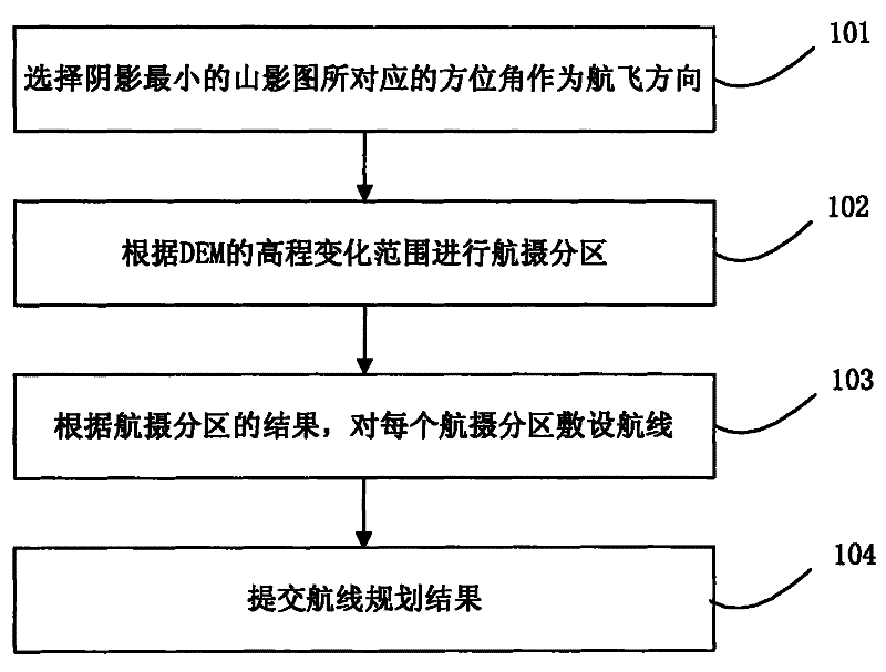
[0029] Since the airborne synthetic aperture radar emits pulses through the side-view method, and forms a strip-like surveying belt as the aircraft flies, its imaging method determines that the previous mature optical photogrammetry route planning technology cannot be copied. It is necessary to develop a route planning scheme suitable for airborne SAR aerial photography on the basis of referring to the route planning of optical photogrammetry and according to the characteristics of airborne SAR itself.

[0030] figure 1 It is a flow chart of airborne synthetic aperture radar route planning in the specific implementation manner of the present invention. Such as figure 1 As shown, the airborne synthetic aperture radar route planning process includes the following steps:

[0031] Step 101. Select th...


PUM


Abstract

The invention discloses a flight planning method for an airborne synthetic aperture radar. The method comprises the following steps: selecting an azimuth angle corresponding to a mountain shadow image having the smallest shadow as a flight direction; dividing aerial photographic zones according to the range of elevation changes of DEM so as to allow the values of elevation changes of DEM in a same aerial photographic zone to be in a range of 1 / 6 to 1 / 4 of flight height; laying flight routes in each aerial photographic zone according to results of the aerial photographic zones. According to the invention, shadows and the phenomenon of layover on an image of the synthetic aperture radar can be maximally reduced, which enables information content of the image of the synthetic aperture radar to be increased and the image to be easier to interpret; flight planning is scientific and reasonable and can effectively reduce cost for aerial photography and enhance efficiency of aerial photography.

Description

technical field [0001] The invention relates to the technical field of aerial surveying and mapping, in particular to an airborne synthetic aperture radar route planning method. Background technique [0002] Airborne SAR (Synthetic Aperture Radar, SAR) aerial photogrammetry is the use of airborne SAR sensors to obtain ground SAR images, after a series of processing, to produce DEM, orthophoto maps, topographic maps, etc. Airborne synthetic aperture radar route planning is the optimal route when designing aerial photography flights. Scientific route planning can reduce the cost of aerial photography and improve production efficiency and product quality. [0003] At present, in the field of aerial photogrammetry route planning, the relatively mature technology is optical photogrammetry route planning. In the field of optical photogrammetry, after decades of development, the route planning technology has been very mature, and now there are many route design software available....

Claims


Application Information

Patent Timeline
Patent Type & Authority Applications(China)
IPC IPC(8): G01C21/24G01C11/00G01S13/90
Inventor 关鸿亮
Owner 关鸿亮
Why Eureka
Try Eureka