Forestry health evaluation system based on aerial remote sensing

A technology for health assessment and aerial remote sensing, applied in the fields of instrument, character and pattern recognition, scene recognition, etc., can solve problems such as differences in research methods and research scales, reduce the accuracy and reliability of monitoring, and one-sided observation, so as to improve research The effect of evaluating ability, ensuring full coverage of monitoring, and ensuring monitoring quality

Inactive Publication Date: 2019-10-08
扆亮海
View PDF7 Cites 19 Cited by
  • Summary
  • Abstract
  • Description
  • Claims
  • Application Information

AI Technical Summary

Problems solved by technology

[0005] There are many deficiencies in the current forestry health evaluation: First, the current forestry health evaluation indicators are not scientifically sound. Researchers in different professional fields have different understandings of forest health standards. They observe the same forest from different angles and consider different indicators. , the evaluation system is incomplete, due to the complexity and variety of research objects, and the differences in research methods and research scales, there is no standard forest health evaluation system at present, and it is difficult to choose an appropriate evaluation method. There are many methods for forest evaluation, and each method is There are advantages and disadvantages. Adopting a certain method may not be able to conduct a comprehensive evaluation of forests. There is a lack of quantitative research on forest health, and there is no in-depth trade-off to understand the relationship between various evaluation indicators. The forestry health evaluation system is not scientific and perfect.
Second, forestry health assessment methods mainly include tower observation, ground inspection and satellite remote sensing, etc., which are backward, costly, and are greatly affected by terrain.

Method used


Image

  • Forestry health evaluation system based on aerial remote sensing
  • Forestry health evaluation system based on aerial remote sensing
  • Forestry health evaluation system based on aerial remote sensing

Examples


Embodiment 1

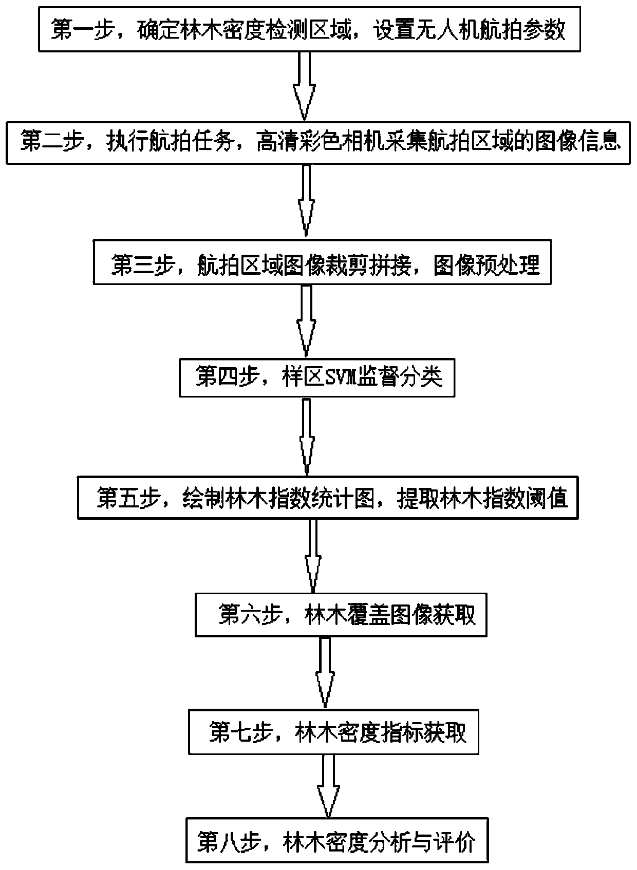
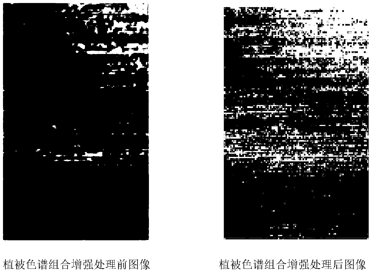
[0138] Example 1: Taking the image of a forest area taken by a drone on September 15, 2018 as an example, the image is interpreted in combination with the results of the field survey, and 110 typical forest area numbers and 110 forest areas are selected on the image according to the field interpretation results. A relatively independent non-tree area, carry out support vector machine supervised classification, the actual situation, the support vector machine has a better effect on the classification of trees and non-trees, on the basis of the results of supervised classification, the tree index S Carry out statistical analysis, statistical histogram, it can be seen from the statistical histogram that the tree index S tree and the intersection point of the non-tree pixel in the statistical histogram are 35.56, and the tree results extracted using the above classification threshold are as follows image 3 As shown in the right figure, the white part represents non-trees, and the ...


PUM


Abstract

The invention provides a forestry health evaluation system based on aerial remote sensing. The system adopts three indexes of tree density, tree growth form and vegetation layer temperature to evaluate the health condition of a forestry, the forest health conditions are analyzed and evaluated from different angles, the three indexes can be used independently, and two or three of the three indexescan be used comprehensively, so that the forestry health research and evaluation capacity is improved. The unmanned aerial vehicle and the 3S technology are combined, so that the innovation speed of the evaluation method is increased, the quantitative research of the healthy forestry is promoted, and the relations among the evaluation indexes are balanced and known deeply, and a perfect forestry health evaluation system is established. The unmanned aerial vehicle is specially designed for the forestry health evaluation system and can obtain the data needed by multiple evaluation indexes at thesame time, an unmanned aerial vehicle flight control system and a geographic information system are combined to fully utilize the geological landform characteristics and the geographic information data of a cruise area, the cruise path design is scientific and reasonable, and the advantages of the unmanned aerial vehicle for evaluating the forestry health are fully exerted.

Description

technical field [0001] The invention relates to a forestry health evaluation system, in particular to a forestry health evaluation system based on aerial remote sensing, and belongs to the technical field of unmanned aerial vehicle forestry health evaluation. Background technique [0002] Forest is the main body of forestry and the basis for the sustainable and healthy development of the entire national economy. Forestry is the economic, aesthetic, ecological and cultural resources that human beings rely on for survival. The role of imbalance. However, in recent years, under the pressure of survival, human beings have caused serious damage to the forest's self-control system and maintenance function through immigration, logging, deforestation, and overgrazing. With the economic development worldwide, forests have been over-cut , forest resources are decreasing, and forest health is facing unprecedented challenges. The productivity and health level of forests are directly r...

Claims


Application Information

Patent Timeline
IPC IPC(8): G06K9/00G06K9/62G06Q50/02
CPCG06Q50/02G06V20/13G06V20/188G06F18/2411G06F18/24
Inventor 扆亮海
Owner 扆亮海
Why Eureka
Try Eureka