Method for acquiring and evaluating urban green land community structure information
A community structure and evaluation method technology, applied to radio wave measurement systems, instruments, etc., can solve problems such as low efficiency and inability to obtain community structure information
- Summary
- Abstract
- Description
- Claims
- Application Information
AI Technical Summary
Problems solved by technology
Method used
Image
Examples
Embodiment 1
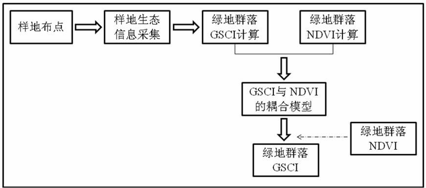
[0024] This example was implemented in Shanghai in 2010, combining ground testing and remote sensing image processing to quickly obtain the community structure information of Shanghai's green space in previous years. Specific steps are as follows:
[0025] (1) Sample plot layout
[0026] Select 120 sample plots in Shanghai, including park green spaces, road green spaces, residential green spaces, protective green spaces and subsidiary green spaces.
[0027] (2) Calculation of the overall community structure integrity index
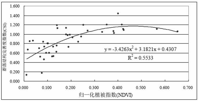
[0028] Six indicators were mainly selected, namely the community structure index x1, the number of trees x2, the total coverage of the community x3, the average tree diameter at breast height x4, the average height of the trees x5 and the average crown width of the trees x6, the overall structure of the community structure index (Community's structure index / CSI).
[0029] ①Shanghai area (at the turn of spring and summer in 2010)
[0030] According to ...
PUM
 Abstract
Description
Claims
Application Information
 - R&D
- Intellectual Property
- Life Sciences
- Materials
- Tech Scout
- Unparalleled Data Quality
- Higher Quality Content
- 60% Fewer Hallucinations
Browse by: Latest US Patents, China's latest patents, Technical Efficacy Thesaurus, Application Domain, Technology Topic, Popular Technical Reports.
© 2025 PatSnap. All rights reserved.Legal|Privacy policy|Modern Slavery Act Transparency Statement|Sitemap|About US| Contact US: help@patsnap.com


