Area quasi-geoid refining method based on earth gravity model (EGM2008)

A technology of EGM2008 and geoid, which is applied in the field of geodesy, can solve the problems of difficulty in obtaining gravity data, low accuracy of calculation results, complex calculation, etc., and achieve the effect of convenient gravity information, expanded application range, and obvious economic benefits

Inactive Publication Date: 2012-07-18
SOUTHEAST UNIV
View PDF2 Cites 13 Cited by
  • Summary
  • Abstract
  • Description
  • Claims
  • Application Information

AI Technical Summary

Problems solved by technology

At present, our country basically adopts the quadratic polynomial fitting method. Although the calculation result of this method is stable, the accuracy of the calculation result is not high, which makes the application range of the GPS elevation measurement results small, and this method does not consider the gravity data. It is a geometric fitting method. face, no physical meaning
[0007] 2) The neural network BP algorithm fitting method, the accuracy of the calculation results is obviously higher than that of the quadratic polynomial fitting method, but the calculation is complicated, the calculation time is long, and the calculation results are unstable. Moreover, if the gravity data is not considered in the input parameters of the BP model, The calculation results also lack physical meaning, so this method is seldom used in engineering at present
[0008] 3) Gravity method, the calculation accuracy is high, and the calculation result can reflect the physical meaning of quasi-geoid, but the gravity data is difficult to obtain, and the calculation is complicated

Method used


Image

  • Area quasi-geoid refining method based on earth gravity model (EGM2008)
  • Area quasi-geoid refining method based on earth gravity model (EGM2008)
  • Area quasi-geoid refining method based on earth gravity model (EGM2008)

Examples


specific example

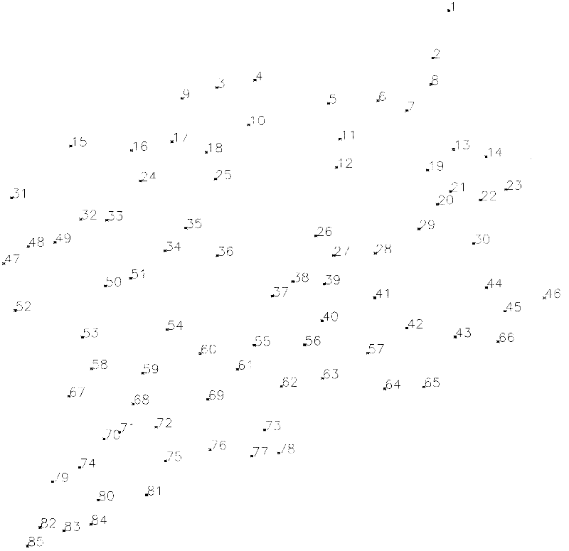
[0040] Specific examples, regional scope: the latitude range is 35°-37° north latitude, the longitude range is 115°-117° east longitude; the regional area is about 200km 2 . Then, 53 "measurement control points" (S=53, see the first 53 points in Table 1) evenly distributed throughout the area are selected in this area. In order to test the effect of the method of the present invention, in fact, we have placed another 32 inspection points in this area (see the last 32 points in Table 1), a total of 85 points. The points are distributed as image 3 Shown.

[0041] 2) Data acquisition. It is required to carry out two measurement tasks on the measurement control points, GPS measurement and leveling measurement, in order to obtain relevant data.

[0042] (1) GPS measurement: In accordance with the requirements of the national measurement specification, carry out B-level or C-level GPS measurement for all control points, the purpose is to obtain the national geodetic coordinate system...


PUM


Abstract

The invention relates to an area quasi-geoid refining method based on an earth gravity model (EGM2008). The method comprises the following steps of: 1) determining an area range and distributing control points; 2) performing field measurement (data acquisition); 3) on the basis of the EGM2008, acquiring a gravity height anomaly of each control point; 4) fitting a quadratic polynomial; 5) measuring adjustment; 6) performing analog computation on a neural network; and 7) refining a model. By adoption of the method, the accuracy of an area height anomaly computation result is high, and the application range of a measurement result of a global positioning system (GPS) height is expanded. Compared with the conventional quadratic polynomial fitting method, the method provided by the invention has the advantages that by a great amount of engineering project application result analysis, the accuracy of a height anomaly computation result is improved by 20 to 50 percent; after the accuracy is improved, the GPS height can replace low-level leveling, so the workload of the conventional low-level leveling which is high in cost, high in difficulty and long in period is reduced to the greatest extent, and economic benefit is obvious; and the method is applicable to the technical field of geodesy.

Description

Technical field [0001] The present invention belongs to the technical field of "geodesis" in the subject of "Surveying and Mapping Science and Technology", and specifically relates to an EGM2008-based refinement method of a regional quasi-geoid. Background technique [0002] The quasi-geoid is the elevation datum for obtaining geospatial information. If a high-precision quasi-geoid model can be established, with the help of high-precision GPS measurement technology, the normal height can be measured indirectly, which can directly serve the engineering application, thereby eliminating the need Traditional leveling with huge workload. At the same time, the establishment and refinement of local or regional geoid models is of great significance to the establishment and maintenance of the national elevation reference frame in the current GPS positioning era, and is also a geodetic infrastructure for the development of surveying and mapping in a country. [0003] In recent years, many c...

Claims


Application Information

Patent Timeline
Patent Type & Authority Applications(China)
IPC IPC(8): G01C5/00
Inventor 胡伍生周洁王浩
Owner SOUTHEAST UNIV
Why Eureka
Try Eureka