
GNSS/IMU (global navigation satellite system/inertial measurement unit) integrated antenna

An antenna and antenna-integrated technology, which is applied to antenna supports/installation devices, radio wave measurement systems, satellite radio beacon positioning systems, etc.

Active Publication Date: 2014-04-02
WUHAN UNIV
View PDF1 Cites 1 Cited by
  • Summary
  • Abstract
  • Description
  • Claims
  • Application Information

AI Technical Summary

Problems solved by technology

In other existing integrated navigation systems, the GNSS antenna and the inertial measurement unit are physically separated, and the uncertainty of the installation position of the two is not only not suitable for high dynamic navigation situations, but also brings serious problems to the precise measurement of the lever arm. difficulty

Method used


Image

  • GNSS/IMU (global navigation satellite system/inertial measurement unit) integrated antenna
  • GNSS/IMU (global navigation satellite system/inertial measurement unit) integrated antenna
  • GNSS/IMU (global navigation satellite system/inertial measurement unit) integrated antenna

Examples


Embodiment Construction

[0033] The present invention provides an integrated antenna design of an antenna of a global satellite positioning system (GNSS) and an inertial measurement unit (IMU, Inertial Measurement Unit) of an inertial navigation system (INS).

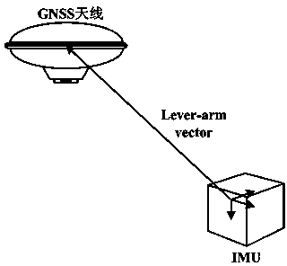
[0034] Such as figure 1 As shown, under normal circumstances, when the GNSS / INS integrated navigation system performs measurement, the GNSS antenna and the IMU are not installed at the same position, and the vector from the IMU measurement center to the GNSS antenna phase center is called the lever-arm vector (Lever-arm vector).

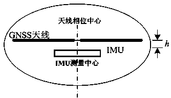
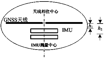
[0035]However, the present invention proposes to integrate one or more GNSS antennas with one or more IMUs. When more than one GNSS antenna is provided, the overall phase center of the GNSS antenna is the equivalent center of the synthesis of the phase centers of each GNSS antenna. When more than one inertial measurement unit is provided, the overall measurement center of the inertial measurement unit is each inertia...


PUM


Abstract

The invention relates to a GNSS / IMU (global navigation satellite system / inertial measurement unit) integrated antenna. One or more GNSS antennas and one or more IMUs are integrally mounted; and the measurement center of the whole IMU and the phase center of the whole GNSS antenna are arranged on the same vertical line or horizontal line, or the measurement center of the whole IMU and the phase center of the whole GNSS antenna are coincided with each other. According to the GNSS / IMU integrated antenna, the measurement center of the whole IMU is coincided with the phase center of the whole GNSS antenna or is equivalently converted to the phase center of the whole GNSS antenna according to the geometrical mounting positions of the IMU and the GNSS antenna, so that the lever arm effect between the IMU and the GNSS antenna is removed, the lever arm compensation process in a combined navigation algorithm is simplified, and the corresponding error is reduced, therefore, the system design is simplified and the convenience is provided for users to mount and use the GNSS / IMU integrated antenna.

Description

technical field [0001] The invention relates to the technical field of a combined navigation system of a global satellite positioning system (GNSS) and an inertial navigation system (INS), in particular to a GNSS / IMU integrated antenna. Background technique [0002] Currently widely used GPS, GLONASS, and the Galileo system being deployed, and my country's Compass (Beidou 2) system all belong to the category of Global Navigation Satellite System (GNSS). Their navigation and positioning principles are all based on the position and velocity of the source of the navigation signal (that is, the satellite) at a certain time, and by measuring the distance between the receiving device and the satellite or parameters such as Doppler to obtain the receiving signal. Navigation parameters such as the device's position and velocity. Taking GPS as an example, the receiver obtains the signal broadcast by the satellite and uses the locally reproduced pseudo-random code to obtain the dista...

Claims


Application Information

Patent Timeline
Patent Type & Authority Patents(China)
IPC IPC(8): G01S19/49H01Q1/22
Inventor 牛小骥班亚龙张提升章红平施闯
Owner WUHAN UNIV
Learn More