
Wireless-sensor-based Internet of things monitoring system and method for geological disaster

A wireless sensor and monitoring system technology, applied in transmission systems, instruments, alarms, etc., can solve the problems of manpower consumption, poor real-time performance, and high cost, and achieve the goal of maintaining social harmony and stability, ensuring the safety of life and property, and quickly querying and updating Effect

Inactive Publication Date: 2012-07-18
CHINA MERCHANTS CHONGQING COMM RES & DESIGN INST
View PDF5 Cites 35 Cited by
  • Summary
  • Abstract
  • Description
  • Claims
  • Application Information

AI Technical Summary

Problems solved by technology

Specifically, it uses synthetic aperture radar interferometry technology to obtain high-resolution ground reflection images from satellites, and judges whether geological disasters have occurred at monitoring points through image analysis. The monitoring system has complex structure, high cost, and poor real-time performance; therefore, it is difficult to achieve Early detection and early treatment of disasters make the prevention and control of geological disasters very passive
[0004] At present, the traditional monitoring device only monitors the abnormal state of the large change in the fracture, and cannot specifically monitor the dynamic process of the change of the fracture, and when the abnormal state of the large change occurs, maintenance personnel need to go to the monitoring node to conduct real-time surveys of the geological conditions on the spot, so that It is not only labor-intensive, but also unable to give early warning of potential hidden dangers in real time, and the effect is not ideal

Method used


Image

  • Wireless-sensor-based Internet of things monitoring system and method for geological disaster
  • Wireless-sensor-based Internet of things monitoring system and method for geological disaster
  • Wireless-sensor-based Internet of things monitoring system and method for geological disaster

Examples


Embodiment Construction

[0040] The preferred embodiments of the present invention will be described in detail below in conjunction with the accompanying drawings; it should be understood that the preferred embodiments are only for illustrating the present invention, rather than limiting the protection scope of the present invention.

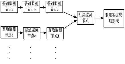
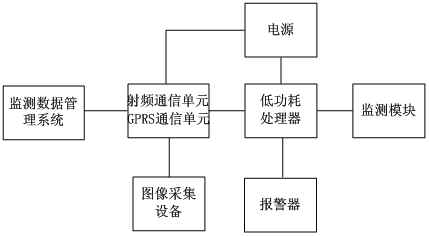
[0041] figure 1 It is a schematic structural diagram of a wireless sensor-based geological disaster Internet of Things monitoring system, as shown in the figure: the wireless sensor-based geological disaster Internet of Things monitoring system provided by the present invention includes a monitoring system and a monitoring data management system; the monitoring system is set in Landslide area monitoring node, the monitoring system is used to collect the disaster body crack state at the location of the monitoring node in real time, and when the disaster body crack state is abnormal, the monitored abnormal disaster body crack state data is uploaded to the monitoring data m...


PUM


Abstract

The invention discloses a wireless-sensor-based Internet of things monitoring system and a wireless-sensor-based Internet of things monitoring method for a geological disaster. The system comprises a plurality of ordinary monitoring nodes, image acquisition equipment, a monitoring sink node and a monitoring data management system, wherein the ordinary monitoring nodes acquire the geological disaster crack state data of places with the monitoring nodes in a multi-hop mode according to preset route, and upload the acquired data to the monitoring sink node; and the monitoring sink node processes and analyzes the data, and uploads the processed data to the monitoring data management system. An Internet of things technology is adopted, and the information of disaster points is acquired through crack sensors, and is transmitted through a wireless general packet radio service (GPRS) network according to a preset transmission route, so that information management over the data of the disaster points is realized; hierarchical alarming is realized in an early warming short message form according to an analysis processing result, so that passive geological disaster prevention work becomes active, the condition of the disaster can be early discovered, and the disaster can be early treated; geological disaster monitoring management working efficiency is greatly improved, prevention and management capability and level are greatly improved; and the whole device is low in energy consumption and cost.

Description

technical field [0001] The invention relates to a geological disaster monitoring system and method, in particular to a wireless sensor-based geological disaster Internet of Things monitoring system. Background technique [0002] Geological hazards refer to geological events that are formed under the action of natural factors or human factors and cause damage to human life, property and living environment, such as collapses, landslides, debris flows, ground fissures, etc. In recent years, with the ravages of extreme weather and the continuous expansion of the scale of human production and living, geological disasters in various regions of the world have become more frequent. [0003] The geohazard monitoring system provided by the prior art utilizes a global positioning system (global positioning system, GPS) to monitor geohazard-prone areas by satellite remote sensing. Specifically, it uses synthetic aperture radar interferometry technology to obtain high-resolution ground ...

Claims


Application Information

Patent Timeline
IPC IPC(8): H04L29/08G08B21/10
Inventor 唐树名罗斌黄河李文峰刘涌江廖强文志兵饶枭宇杨静
Owner CHINA MERCHANTS CHONGQING COMM RES & DESIGN INST
Learn More